Met1985
-
Posts
15,300 -
Joined
-
Last visited
Content Type
Profiles
Blogs
Forums
American Weather
Media Demo
Store
Gallery
Everything posted by Met1985
-
Looks like a wide area of 8 to 12 inches.
-
You're going to end up with a foot.
-
18z NAM..... Sent from my SM-G998U using Tapatalk
-
Multiple rounds of heavy rainfall are expected due to the interaction of tropical moisture along a stationary front, followed by the passage of Tropical Storm Helene. Storm-total rainfall of 8-12 inches is expected along the entire length of the Blue Ridge Escarpment with widespread 5-8 inches expected across the remainder of the mountains as well as the Piedmont. This has the potential to be an extremely rare event with significant and damaging flash-flooding along numerous streams.
-
Rabun-Avery-Madison-Yancey-Mitchell-Swain-Haywood-Buncombe-Graham- Northern Jackson-Macon-Southern Jackson-Transylvania-Henderson- Caldwell Mountains-Burke Mountains-McDowell Mountains-Rutherford Mountains-Polk Mountains-Oconee Mountains-Pickens Mountains- Greenville Mountains- Including the cities of Hot Springs, Mountain Rest, Cullowhee, Kyle, Franklin, Sylva, Brevard, Ramseytown, Spruce Pine, Asheville, Alarka, Stecoah, Old Fort, Busick, Mountain City, Cruso, Canton, Jonas Ridge, Cedar Mountain, Saluda, Burnsville, Swiss, East Flat Rock, Waterville, Black Mountain, Cashiers, Newland, Ingalls, Almond, Luada, Banner Elk, Bryson City, Cove Creek, Wesser, Faust, Micaville, Marshall, Walnut, Poplar, Robbinsville, Rainbow Springs, Patterson, Tuckasegee, Little River, Woodlawn, Chimney Rock State Park, Mars Hill, Glassy Mountain, Waynesville, Highlands, Ashford, Pine Mountain, Luck, Hendersonville, Etowah, Sugar Hill, Fletcher, Celo, Allenstand, Rocky Bottom, Clayton, Tuxedo, Wolf Mountain, Dana, and Candler 322 PM EDT Tue Sep 24 2024 ...FLOOD WATCH IN EFFECT FROM WEDNESDAY MORNING THROUGH FRIDAY AFTERNOON... * WHAT...Flash flooding caused by excessive rainfall is possible. * WHERE...Portions of northeast Georgia, including the following area, Rabun, western North Carolina, including the following areas, Avery, Buncombe, Burke Mountains, Caldwell Mountains, Graham, Haywood, Henderson, Macon, Madison, McDowell Mountains, Mitchell, Northern Jackson, Polk Mountains, Rutherford Mountains, Southern Jackson, Swain, Transylvania and Yancey, and upstate South Carolina, including the following areas, Greenville Mountains, Oconee Mountains and Pickens Mountains. * WHEN...From Wednesday morning through Friday afternoon. * IMPACTS...Excessive runoff may result in significant and damaging flooding of rivers, creeks, streams, and other low-lying and flood-prone locations. Areas that are not typically impacted by floodwaters may flood.
-
Thank you! I forgot about the 3 dots!
-
No you can change it. It should allow you to modify the thread name.
-
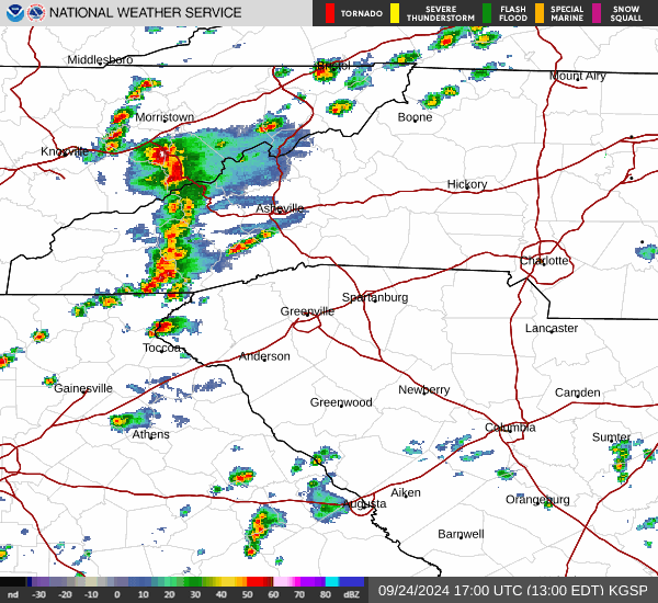
Yeah that line is freaking blowing up now.
-
12z euro. Not good. Sent from my SM-G998U using Tapatalk

-
Big storms rolling through. Sent from my SM-G998U using Tapatalk
-
STRONG THUNDERSTORMS WILL IMPACT EASTERN MACON...JACKSON...EAST CENTRAL SWAIN AND CENTRAL HAYWOOD COUNTIES THROUGH 130 PM EDT... At 1249 PM EDT, Doppler radar was tracking strong thunderstorms along a line extending from 10 miles northwest of Waynesville to 10 miles south of Sylva to 7 miles north of Clayton. Movement was northeast at 25 mph. HAZARD...Wind gusts up to 50 mph. SOURCE...Radar indicated. IMPACT...Gusty winds could knock down tree limbs and blow around unsecured objects. Locations impacted include... Sylva, Waynesville, Franklin, Cherokee, Cullowhee, Lake Junaluska, Highlands, Maggie Valley, Balsam, and Webster. PRECAUTIONARY/PREPAREDNESS ACTIONS...
-
Yeah it does. I really don't think it will move much more than it has because of the Apps and the steering current.
-
Yeah that's not good at all.
-
12z gfs Helene run Sent from my SM-G998U using Tapatalk

-
Looks like the upper low pushes is a bit further east this run.
-
12z gfs honing in on the predecessor rainfall. Sent from my SM-G998U using Tapatalk
.thumb.jpg.f23bb6fdd3efb9a0ac83c940cb850bb3.jpg)
-
12z gfs. Predecessor rainfall. Sent from my SM-G998U using Tapatalk
.thumb.jpg.d3de59adb12f152be1191820edc69a45.jpg)
-
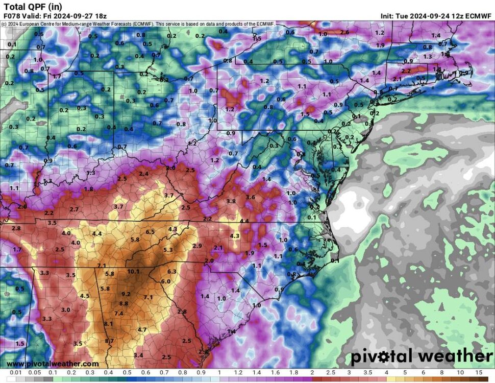
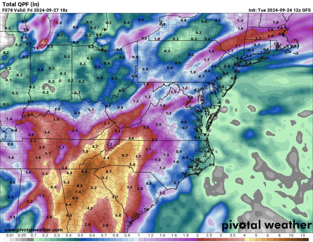
Yeah and if Helene comes through like the models are showing this is underestimating totals. I know I said that yesterday but this is a big issue if true. That's basically 5 to 10 inches plus for several in the viewing area.
-
I remember this back then because we had those really cold winters back to back. I remember this circulating into more violent storms across the world and the USA. Very interesting indeed.
-
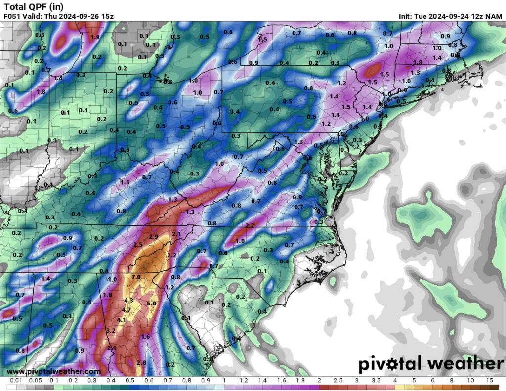
Don't look now but we have flooding concerns even before Helene gets here. 12z NAM. Sent from my SM-G998U using Tapatalk

-
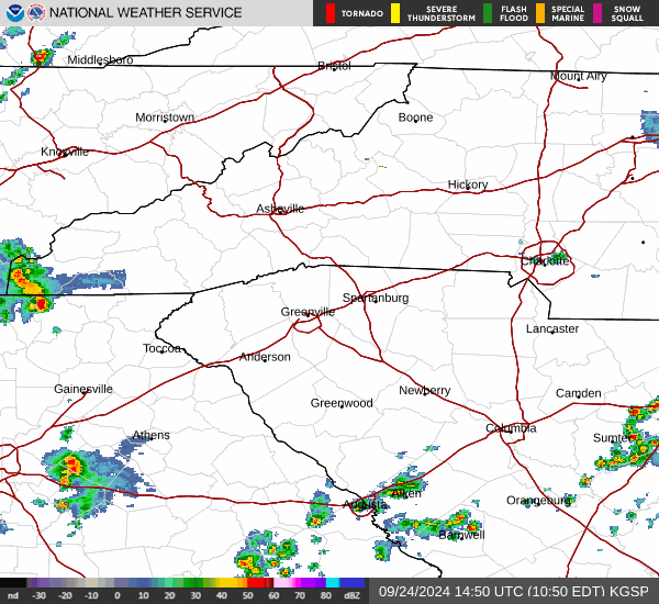
Storms already firing this morning. Sent from my SM-G998U using Tapatalk
-
Thank you Don. Much appreciated and love to continue to learn about this. As many have mentioned we are in new territory with all this is seems.
-
This predecessor rainfall event may be a death blow to us. This keeps inching more and more into our area for heavy rainfall from this first upper low. 12z NAM... Sent from my SM-G998U using Tapatalk

-
As I say the above just to help keep things grounded but the way things look currently we are in fact in the bullseye with this thing and as mentioned from previous post in the tropical thread this thing might be moving at 25mph. Good for cutting down on rainfall rates a but but bad because the wind field will be mostly intact and that could be very damaging to the area.
-
So if I'm reading this correct Don, this would not bode well for NAO blocking during the winter months? I can't really remember when we had just decent blocking in September at all.


.jpg.8be6e16764b0395b70d33b1759570c25.jpg)
.jpg.ec4f1032f3bc27bb31abead77afc0972.jpg)