

Met1985
-
Posts
15,301 -
Joined
-
Last visited
Content Type
Profiles
Blogs
Forums
American Weather
Media Demo
Store
Gallery
Everything posted by Met1985
-
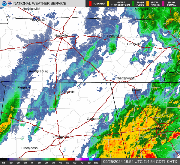
Tropical storm warning now... Sent from my SM-G998U using Tapatalk
.jpg.7d711805e1026d6904898c01018c75d7.jpg)
-
TROPICAL STORM WARNING IN EFFECT... A Tropical Storm Warning means tropical storm-force winds are expected somewhere within this area within the next 36 hours * LOCATIONS AFFECTED - Waynesville * WIND - LATEST LOCAL FORECAST: Tropical storm force winds remain possible - Peak Wind Forecast: 15-25 mph with gusts to 45 mph - THREAT TO LIFE AND PROPERTY THAT INCLUDES TYPICAL FORECAST UNCERTAINTY IN TRACK, SIZE AND INTENSITY: Potential for wind 39 to 57 mph - The wind threat has remained nearly steady from the previous assessment. - PLAN: Plan for hazardous wind of equivalent tropical storm force. - PREPARE: Efforts to protect property should now be underway. Prepare for limited wind damage. - ACT: Act now to complete preparations before the wind becomes hazardous. - POTENTIAL IMPACTS: Limited - Damage to porches, awnings, carports, sheds, and unanchored mobile homes. Unsecured lightweight objects blown about. - Many large tree limbs broken off. A few trees snapped or uprooted, but with greater numbers in places where trees are shallow rooted. Some fences and roadway signs blown over. - A few roads impassable from debris, particularly within urban or heavily wooded places. Hazardous driving conditions on bridges and other elevated roadways. - Scattered power and communications outages. * FLOODING RAIN - LATEST LOCAL FORECAST: Flood Watch is in effect - Peak Rainfall Amounts: Additional 8-12 inches, with locally higher amounts
-
Just roll with it. Just stay up to date and make sure your prepared.
-
Sheet!
-
What are up to already? 5 plus?
-
Yep flash flooding warning for the Pigeon River from Tomorrow through Friday.
-
Yeah I swore we had some brief hail in Canton about 10 minutes ago.
-
Will be one hell of a flight! Stay safe!
-
This stuff coming from Atlanta means business. Sent from my SM-G998U using Tapatalk
-
Yall want to do an obs thread or just keep everything here? Also torrential rainfall with lots of lightning.
-
I believe it because it's basically what all the other models show.
-
Seems like I'm fighting dry air. Temps have dropped to 66 but not much rain which is freaking great.
-
Just light rain here but I hear the thunder coming.
-
This is pretty amazing. Look at the fetch of moisture all the way down in the Gulf. Sent from my SM-G998U using Tapatalk
-
Our county just pulled the trigger about an hour ago. Closed school the rest of the week. A great decision indeed and couldn't agree more.
-
It won't matter here. Shits going to be unhinged if the forecasts are correct.
-
Yeah all of WNC could have a lot of damage when all is said and done in this area.
-
No doubt! Amazing.
-
Never have I seen this either. Great action from the NWS here. Sent from my SM-G998U using Tapatalk
-
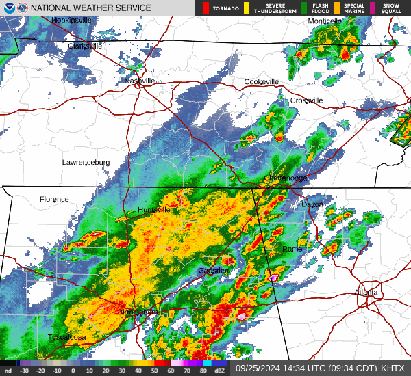
TROPICAL STORM WATCH IN EFFECT... A Tropical Storm Watch means tropical storm-force winds are possible somewhere within this area within the next 48 hours * LOCATIONS AFFECTED - Waynesville * WIND - LATEST LOCAL FORECAST: Below tropical storm force wind - Peak Wind Forecast: 20-30 mph with gusts to 55 mph - THREAT TO LIFE AND PROPERTY THAT INCLUDES TYPICAL FORECAST UNCERTAINTY IN TRACK, SIZE AND INTENSITY: Potential for wind 39 to 57 mph - PLAN: Plan for hazardous wind of equivalent tropical storm force. - PREPARE: Efforts to protect property should now be underway. Prepare for limited wind damage. - ACT: Act now to complete preparations before the wind becomes hazardous. - POTENTIAL IMPACTS: Limited - Damage to porches, awnings, carports, sheds, and unanchored mobile homes. Unsecured lightweight objects blown about. - Many large tree limbs broken off. A few trees snapped or uprooted, but with greater numbers in places where trees are shallow rooted. Some fences and roadway signs blown over. - A few roads impassable from debris, particularly within urban or heavily wooded places. Hazardous driving conditions on bridges and other elevated roadways. - Scattered power and communications outages. * FLOODING RAIN - LATEST LOCAL FORECAST: Flood Watch is in effect - Peak Rainfall Amounts: Additional 6-10 inches, with locally higher amounts
-
I'd think that would be enough time especially with the heat down there but just in case I wouldn't lift the door up at all until after all this is settled if you can help it.
-
We got us a Hurricane! Hurricane Helene. 80mph 979mb
-
I'm watching this really close. I think this is the start of everything this afternoon. Sent from my SM-G998U using Tapatalk
-
Huge increase on the NAM from 6z.
-
Yeah looks like it's going to miss the Yucatan which will only help this thing become a monster. It's already a very large storm.


