Met1985
-
Posts
15,301 -
Joined
-
Last visited
Content Type
Profiles
Blogs
Forums
American Weather
Media Demo
Store
Gallery
Everything posted by Met1985
-
Looks like the French broad river is forecast to crest at 31 feet tomorrow at around 2pm. To put that in perspective that's 10 FEET above the record from 2004. This coming from the NWS...
-
Yeah winds at 125mph but pressure is steadily dropping. This is the best Helene has looked and right before landfall.
-
Another 1.25 inches in the rain guage. 5.07 total.
-
This is significant. Once it's wrapped it will strengthen pretty rapidly until landfall.
-
Head for cover!
-
I don't doubt it. That's going to be ground zero right there.
-
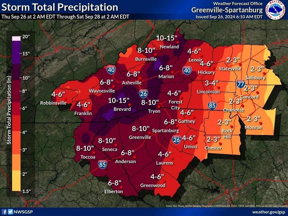
This came out of the NWS GSP office. It's on there Facebook page.
-
Just getting word from emergency management in Haywood that they are evacuating everyone in and around the Lake Logan area.
-
Thank you. We will be keeping everyone up to date in our SE thread but the NWS is saying this will be historical. Some very strong working out of NWS GSP today.
-
Thank you. We will definitely be on edge tonight through tomorrow. We have already seen a lot of flooding in various communities.
-
No it's definitely not hype at all here in WNC. We have families moving away from the rivers tonight and we are really worried about the saturated grounds and 60mph wind gusts.
-
Yeah we've been in moderate rainfall for over an hour now.
-
This looks really bad for us. Sent from my SM-G998U using Tapatalk
-
In my opinion this thing is so big that it's not a tight clustered system that goes off like a bomb all at once. This thing had been building into an absolute monster of a system so it takes time for things to come together and mix out the dry air. But the thing is the bigger this thing gets the harder it will be to slow her down... Just my opinion on the evolution of Helene currently.
-
This thing is getting it together.
-
I think that is a smart decision. Better safe than sorry man. Especially with you having a family.
-
That's what really worries me. The ground is saturated and we don't get winds like that here. That could cause some major problems.
-
Ah ok! Well good to know then.
-
Thank you! I believe the region is ready for whatever happens.
-
Yeah we have local online news papers sharing it also online.
-
Be safe down there Don.
-
It's fake but with the additional rainfall that the NWS has worded there are communities that will see 20 to 30 inches of rainfall total. That is no joke. Several places already have seen 8 plus here. And additional 9 to possibly 20 inches would certainly be historical in nature. The strong wording from the NWS lends credence to that.
-
This just came across there Facebook page about 10 minutes ago...
-
The urgent message from the NWS is about as dire as I've ever heard from them with a situation like this...
-
[As of 800 AM Thur 9/26] Additional rainfall of 9-14" with local amounts up to 20" is expected along and near the Blue Ridge Escarpment through Friday morning, with 5-9" expected elsewhere. Numerous flash flood warnings have been issued for portions of the area, with a lot of additional rain on the way. Dangerous catastrophic flash-flooding is expected along numerous streams, especially in the North Carolina/South Carolina mountains and northeast Georgia. Flooding of mainstem rivers is expected, with major to possibly historic flooding likely near the Blue Ridge Escarpment. Confidence is high in landslides and debris flows occurring during the heaviest rainfall tonight through at least 12 pm Friday. Wind gusts of 45 to 60 mph are expected tonight into Friday, with brief 60 to 70 mph gusts possible across the western part of the area. Widespread downed trees and numerous power outages likely. Isolated tornadoes are possible through Friday morning. Safety Message: Never drive around barricades, get higher ground, do not drive into water, and stay informed throughout the entirety of the event. #scwx #ncwx #gawx Sent from my SM-G998U using Tapatalk