

Met1985
-
Posts
16,974 -
Joined
-
Last visited
Content Type
Profiles
Blogs
Forums
American Weather
Media Demo
Store
Gallery
Everything posted by Met1985
-
This would be good for the drought. Sent from my SM-G998U using Tapatalk

-
No snow per the Euro. All ice or rain. Sent from my SM-G998U using Tapatalk

-
Rainer for the SW mountains and the other side of TN. Sent from my SM-G998U using Tapatalk
.thumb.jpg.6941d98947615eb6fd44737be7db2ea9.jpg)
-
That would be catastrophic to the grid.
-
Border counties turn to rain by Sunday morning. This run is a dumpster fire. Sent from my SM-G998U using Tapatalk
.thumb.jpg.4cc7b1c8ed83216809dd6068202a6bfa.jpg)
-
Euro looks like crap right off the bat. Sent from my SM-G998U using Tapatalk
.thumb.jpg.9126427d6c34980ebb3fef4e619fd647.jpg)
-
Apparently the Euro is broken.
-
No freaking kidding! Talk about a rocket ship!
-
Yep I agree also Tyler. That stuff would stick around forever.
-
Can someone post the sleet map. I can't get it currently..thank you.
-
Fun times. Sent from my SM-G998U using Tapatalk

-
Can someone get a sleet map?
-
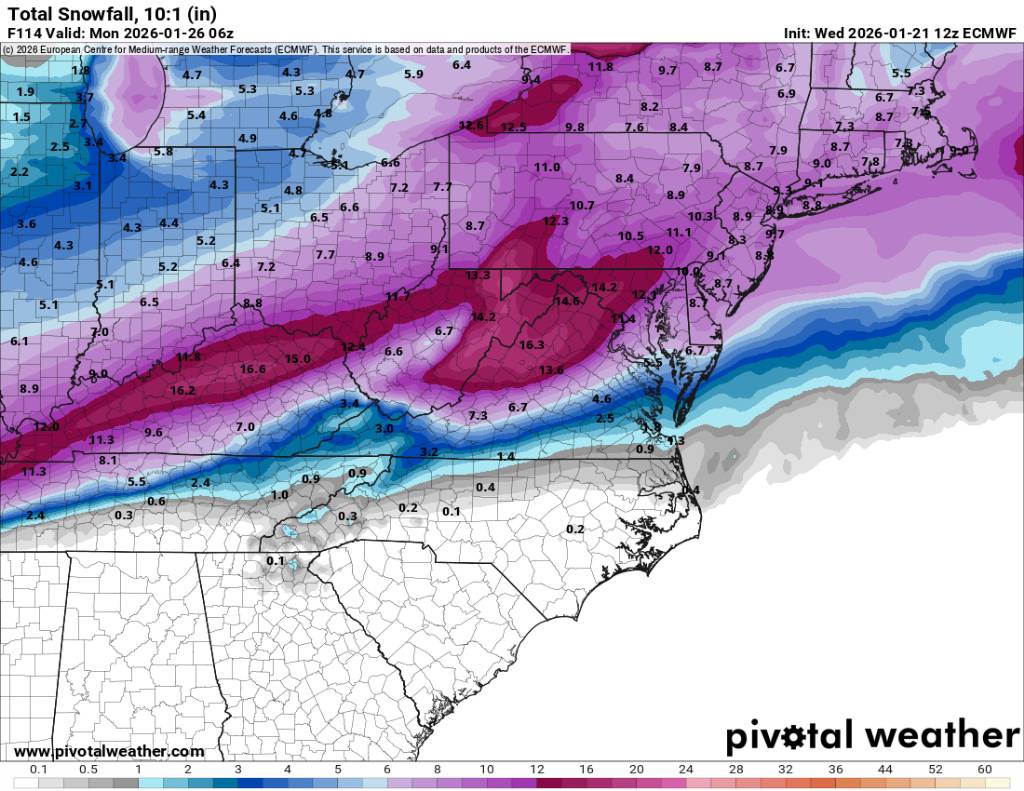
Yeah and that would stick around for a good week especially with what the Euro is showing. That crap would be super thick.
-
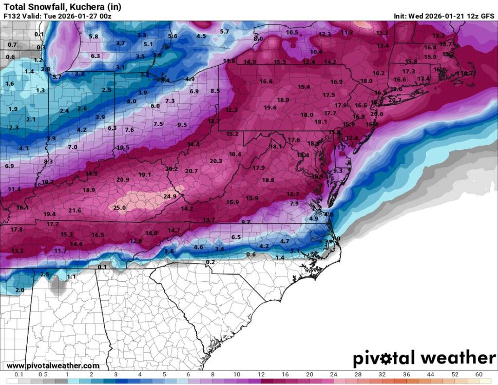
12z gfs totals. I don't have the sleet totals. Sent from my SM-G998U using Tapatalk
-
Flow snow would be a big factor on the back end in my opinion. Sent from my SM-G998U using Tapatalk
.thumb.jpg.4fbdd192f964752ca741b0e3d0ae499e.jpg)
-
Temps crashing on the backside. I bet a lot see this end in heavy snow. Sent from my SM-G998U using Tapatalk
.thumb.jpg.06662bac1525b021204d21c0e800efae.jpg)
-
This is an interesting look. Sent from my SM-G998U using Tapatalk
.thumb.jpg.364e7f0d9ed1610b5c014eb37d089b3f.jpg)
-
Yes that would be something else for sure.
-
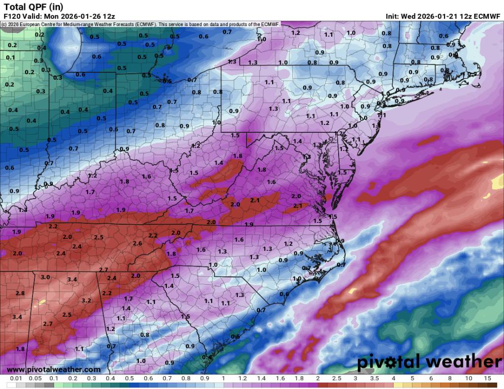
Snow, mix, and freezing rain for the southern mountains. And this is some heavy precipitation. Sent from my SM-G998U using Tapatalk
.thumb.jpg.ea9b093257ca932a2dc01d794025d4b6.jpg)
-
The transition is pretty quick on this run. This would be a freaking mess. Sent from my SM-G998U using Tapatalk
.thumb.jpg.6b2cbe92ba5f8c30295b4312eb86da6f.jpg)
-
Start of storm on gfs. Sent from my SM-G998U using Tapatalk
.thumb.jpg.2ae90c928ae9984b6ff268a4332508c8.jpg)
-
Bingo Hunter! Yes sir.
-
The 12z gfs will start out as snow for us.
-
That would be a crippling ice storm for all.
-
12z gfs is running. Let's see what we got.

.jpg.6ef6d0beba1a715f67ed735c92157a30.jpg)

.jpg.8441307d5661a689330838cbc9beff60.jpg)
.jpg.5bd355a69d941b53646ce6742d587e9f.jpg)


.jpg.dea03b3ea78d5e0fd9751927ac3d18e8.jpg)

.jpg.fe5e5385425f450bcf8fa11517474956.jpg)
.jpg.4103b30d3105a691b483d31d9735a568.jpg)
.jpg.210fa723649e80761959e5a7931572ab.jpg)
.jpg.18883079b6de6423abfd69b57a005486.jpg)
.jpg.69102350cc287afde6475d6d91c23796.jpg)