Met1985
-
Posts
16,969 -
Joined
-
Last visited
Content Type
Profiles
Blogs
Forums
American Weather
Media Demo
Store
Gallery
Everything posted by Met1985
-

2022-2023 Fall/Winter Mountains Thread
Met1985 replied to BlueRidgeFolklore's topic in Southeastern States
Yeah I read where several areas are running 1 to 2 degrees below what February was running. Pretty rare and remarkable up to this point. -
Yeah I saw this also. You can see on the euro how it has a big high coming down as well. The cold is not over yet.
-
2022-2023 Fall/Winter Mountains Thread
Met1985 replied to BlueRidgeFolklore's topic in Southeastern States
Wow what an impressive cold morning for March 20th... Our low this morning of 10 degrees! That's got to be close to a record. Heck I think that's the coldest we've been since January. -
2022-2023 Fall/Winter Mountains Thread
Met1985 replied to BlueRidgeFolklore's topic in Southeastern States
Temps are absolutely nosediving this evening. Already down to 23 degrees at 8pm. Very impressive for this time of year. -
2022-2023 Fall/Winter Mountains Thread
Met1985 replied to BlueRidgeFolklore's topic in Southeastern States
Ended up.with a low of 16 this morning. Current temp is 30 already. -
2022-2023 Fall/Winter Mountains Thread
Met1985 replied to BlueRidgeFolklore's topic in Southeastern States
Yeah with the cloud cover the temp didn't drop really quickly until right when I was leaving and that was when it was beginning to clear out. No two ways about it. This is very cold for this time of the year. -
March 2023 Mid-Long Range Discussion thread
Met1985 replied to Holston_River_Rambler's topic in Tennessee Valley
Yes very cold on this side of the mountains with lows in the teens and the single digits... -
2022-2023 Fall/Winter Mountains Thread
Met1985 replied to BlueRidgeFolklore's topic in Southeastern States
When I left the house it was 21 degrees this morning at 4 am. We had on and off snow showers through the night with a light dusting. -
2022-2023 Fall/Winter Mountains Thread
Met1985 replied to BlueRidgeFolklore's topic in Southeastern States
No snow but had a low of 25 this morning. -
2022-2023 Fall/Winter Mountains Thread
Met1985 replied to BlueRidgeFolklore's topic in Southeastern States
Well we might not be getting snow but dang if it's not going to be cold. -
2022-2023 Fall/Winter Mountains Thread
Met1985 replied to BlueRidgeFolklore's topic in Southeastern States
Yeah this is the doing of the ssw and mjo. A direct correlation. -
2022-2023 Fall/Winter Mountains Thread
Met1985 replied to BlueRidgeFolklore's topic in Southeastern States
Yeah and it's going to be even colder the end of the weekend. -
2022-2023 Fall/Winter Mountains Thread
Met1985 replied to BlueRidgeFolklore's topic in Southeastern States
Decent signal 10 days out but even the ensembles have been horrible this season. Sent from my SM-G998U using Tapatalk.thumb.jpg.d542c0c96649adfe34af2eee6fc6b1ed.jpg)
-
2022-2023 Fall/Winter Mountains Thread
Met1985 replied to BlueRidgeFolklore's topic in Southeastern States
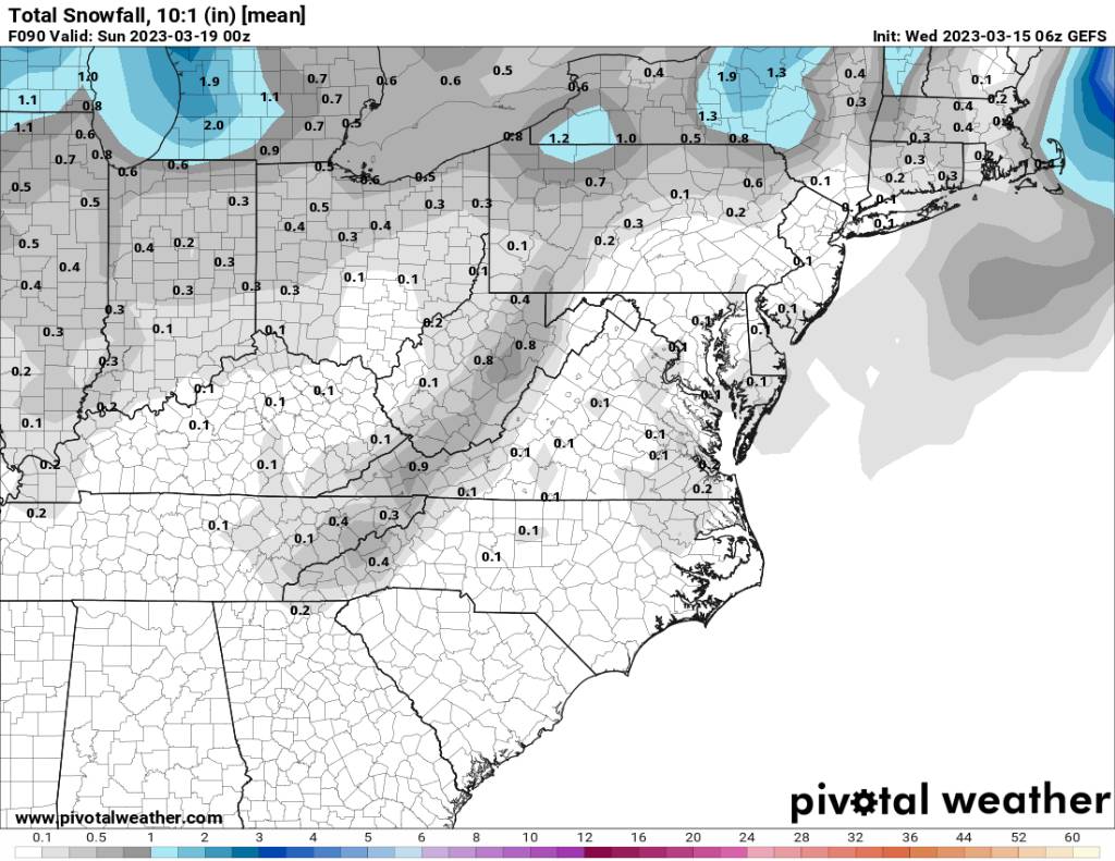
A decent signal for some backside flakes this Sunday on the mean. Sent from my SM-G998U using Tapatalk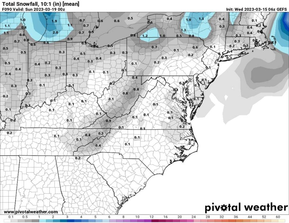
-
2022-2023 Fall/Winter Mountains Thread
Met1985 replied to BlueRidgeFolklore's topic in Southeastern States
A freaking cold morning. Low of 18 degrees. -
Not going to happen.
-
2022-2023 Fall/Winter Mountains Thread
Met1985 replied to BlueRidgeFolklore's topic in Southeastern States
Had some light snow this morning when I left for work. Temp at 4 was 22 degrees -
2022-2023 Fall/Winter Mountains Thread
Met1985 replied to BlueRidgeFolklore's topic in Southeastern States
Getting some light snow this evening. -
2022-2023 Fall/Winter Mountains Thread
Met1985 replied to BlueRidgeFolklore's topic in Southeastern States
Looks like winter will hang on a bit longer. Looks like there are several chances for some flakes around the border county in the next few days. Going to be pretty cold also with lows in the teens and 20s. -
Congratulations guys to those seeing some snow and sleet!
-
2022-2023 Fall/Winter Mountains Thread
Met1985 replied to BlueRidgeFolklore's topic in Southeastern States
Lol probably. Only one time this season that the models didn't deviate out and that was the upslope storm we had. -
2022-2023 Fall/Winter Mountains Thread
Met1985 replied to BlueRidgeFolklore's topic in Southeastern States
Eh it's hard to tell. The pattern will change hopefully. There are a ton of variables but I do think that we will be stuck with a bad Pacific for a few years. Something about everything balancing out in the west. They had severe drought for several years and now I think they are going to have some really big surpluses the next several winters which really they need. -
2022-2023 Fall/Winter Mountains Thread
Met1985 replied to BlueRidgeFolklore's topic in Southeastern States
Well the models have trended like crap this weekend. This has been a horrendous pattern really since December. I might need to move out west if this is going to be the norm. Especially with a negative pdo which last decades. The SER has been an immovable force this winter as well. A lot of just bad upper atmosphere drivers this winter. -
2022-2023 Fall/Winter Mountains Thread
Met1985 replied to BlueRidgeFolklore's topic in Southeastern States
Yeah heavy frost with a temp of 27 this morning. -
As GA has explained it's a lot more complex than that. Especially when you have blocking over the top, a decaying Nina, a 50/50 low, different wavelengths.... It's a lot.

.jpg.5e6e030ae95e4c70a158dad5132294fa.jpg)