Met1985
-
Posts
15,295 -
Joined
-
Last visited
Content Type
Profiles
Blogs
Forums
American Weather
Media Demo
Store
Gallery
Everything posted by Met1985
-

2022-2023 Fall/Winter Mountains Thread
Met1985 replied to BlueRidgeFolklore's topic in Southeastern States
That's crazy even with your snowpack... Current temp this morning is 15 degrees. Done chilling cold with no snowpack. -
2022-2023 Fall/Winter Mountains Thread
Met1985 replied to BlueRidgeFolklore's topic in Southeastern States
Yeah it's flipping freezing out especially with a bit of a breeze out. -
2022-2023 Fall/Winter Mountains Thread
Met1985 replied to BlueRidgeFolklore's topic in Southeastern States
18z gfs says lets do super cold all over again at the first of February... -
2022-2023 Fall/Winter Mountains Thread
Met1985 replied to BlueRidgeFolklore's topic in Southeastern States
18z gfs looks awesome for the northern mountains with this next system... Everyone else is sucking dust lol. Sent from my SM-G998U using Tapatalk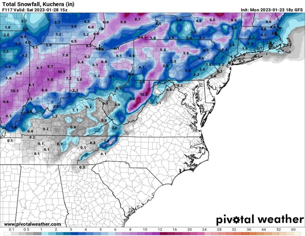
-
2022-2023 Fall/Winter Mountains Thread
Met1985 replied to BlueRidgeFolklore's topic in Southeastern States
The euro looks pathetic with this next system. Im leaning towards the euro because it was anemic looking for today's snowfall and it was right. It beat the gfs and the NAM. The mid to long range looks really good from about February 2nd until about the 9th or 10th. On all the ensembles this range looks really good. The only problem is that it's 11 days away. We will see if this is the same song and dance bullcrap from the models. -
2022-2023 Fall/Winter Mountains Thread
Met1985 replied to BlueRidgeFolklore's topic in Southeastern States
Current temp of 29 degrees with on and off snow with a dusting. This is more of a westerly flow. Not that great for myself but better for places like Maggie Valley. -
2022-2023 Fall/Winter Mountains Thread
Met1985 replied to BlueRidgeFolklore's topic in Southeastern States
31 degrees with moderate snow falling. -
2022-2023 Fall/Winter Mountains Thread
Met1985 replied to BlueRidgeFolklore's topic in Southeastern States
The 12z euro is not as enthusiastic as the American models Sent from my SM-G998U using Tapatalk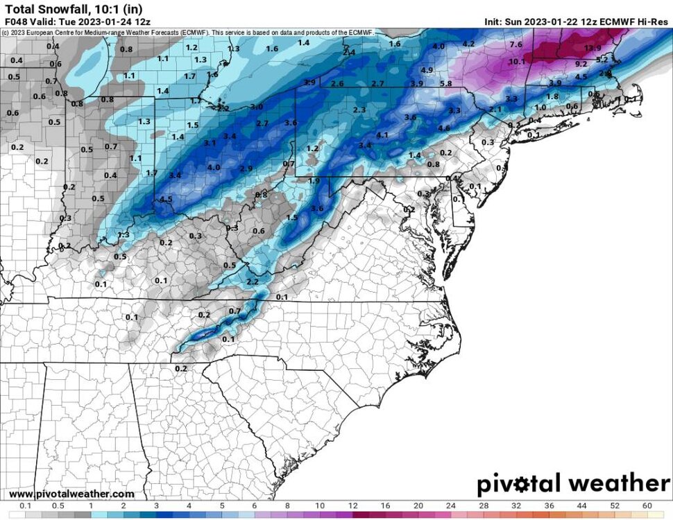
-
2022-2023 Fall/Winter Mountains Thread
Met1985 replied to BlueRidgeFolklore's topic in Southeastern States
18z gfs looks great for the northern mountains. Sent from my SM-G998U using Tapatalk.thumb.jpg.4798883376bf3387708bfe876b1ede6c.jpg)
-
2022-2023 Fall/Winter Mountains Thread
Met1985 replied to BlueRidgeFolklore's topic in Southeastern States
The 18z NAM looks great for the northern mountains. Sent from my SM-G998U using Tapatalk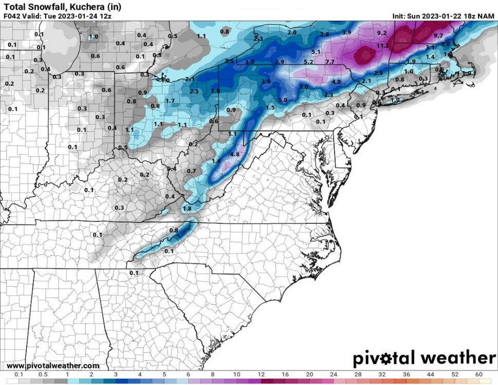
-
2022-2023 Fall/Winter Mountains Thread
Met1985 replied to BlueRidgeFolklore's topic in Southeastern States
Lets do some analysis today. This is todays snapshot of the 12z eps run today. For my variable point of the 30th of this month then 10 days out. The eps has cooled a lot since yesterday. Could be because of the current SSW that will start tomorrow in the Arctic. There is a lot of volatility on the ensembles which makes me think that the whole northern hemisphere is going to experience a big shift soon. Sent from my SM-G998U using Tapatalk -
January 2023 Medium/Long Range Pattern Discussion Thread
Met1985 replied to Carvers Gap's topic in Tennessee Valley
Lol at least yall will make up for such a dry Fall this way. At least one positive.- 923 replies
-
- 1
-

-
- warm start
- cold
- (and 4 more)
-
2022-2023 Fall/Winter Mountains Thread
Met1985 replied to BlueRidgeFolklore's topic in Southeastern States
It is a crying shame that in the extended range in January we get a low that tracks south of us and we still cannot pull a snowstorm out of that scenario. I don't care what you say. That is a sign of a crap pattern if there ever was one. -
2022-2023 Fall/Winter Mountains Thread
Met1985 replied to BlueRidgeFolklore's topic in Southeastern States
Again on the 12z gfs suite the se ridge is getting besten back by the tpv which could allow for a sneaky system late in the game. My target date of 01-30 has been cooling down since yesterday on the operationals and the ensembles. -
2022-2023 Fall/Winter Mountains Thread
Met1985 replied to BlueRidgeFolklore's topic in Southeastern States
On the 12z gfs the clipper coming in looks best for the northern mountains. It looks pathetic really. Seems like it's going the way of the euro. Sent from my SM-G998U using Tapatalk
-
2022-2023 Fall/Winter Mountains Thread
Met1985 replied to BlueRidgeFolklore's topic in Southeastern States
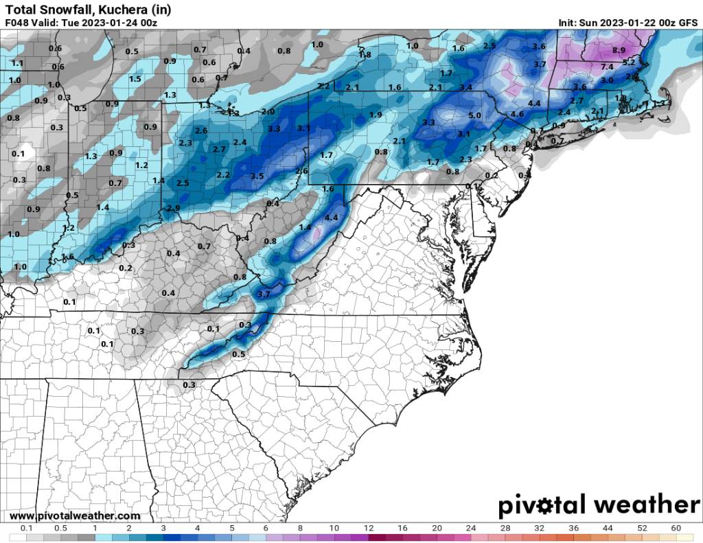
12z gfs goes with more of a uniform look across the mountains Sent from my SM-G998U using Tapatalk
-
2022-2023 Fall/Winter Mountains Thread
Met1985 replied to BlueRidgeFolklore's topic in Southeastern States
12z NAM going with the north mountains currently. Sent from my SM-G998U using Tapatalk.thumb.jpg.d399cf1dfd3366782bc92d1a2961dd42.jpg)
-
2022-2023 Fall/Winter Mountains Thread
Met1985 replied to BlueRidgeFolklore's topic in Southeastern States
I've noticed that the ensembles have backed off the se ridge today even the eps but the eps is the warmer Ensemble out of all of them which is concerning. -
2022-2023 Fall/Winter Mountains Thread
Met1985 replied to BlueRidgeFolklore's topic in Southeastern States
Temp just backed down to 31 with some snow mixing in now. Back to bed for me. -
2022-2023 Fall/Winter Mountains Thread
Met1985 replied to BlueRidgeFolklore's topic in Southeastern States
Good morning everyone. Surprisingly we are sitting right at 32 degrees getting a mixture of rain and sleet this morning. -
2022-2023 Fall/Winter Mountains Thread
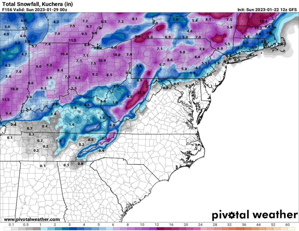
Met1985 replied to BlueRidgeFolklore's topic in Southeastern States
The 00z gfs for tomorrow night into Monday Sent from my SM-G998U using Tapatalk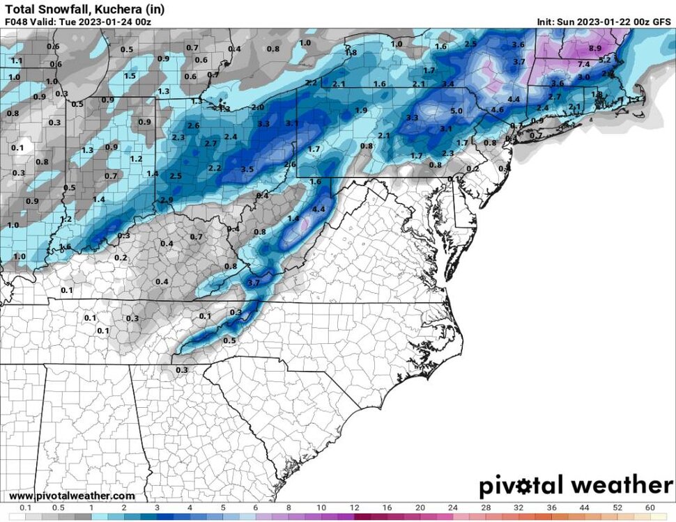
-
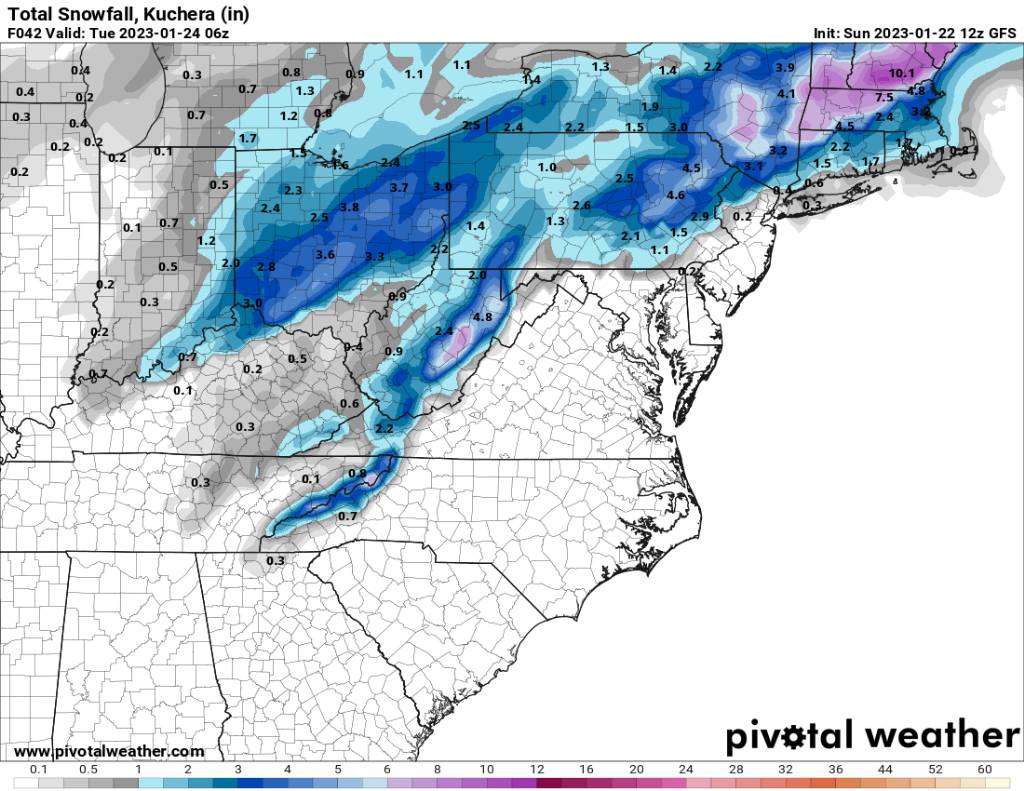
2022-2023 Fall/Winter Mountains Thread
Met1985 replied to BlueRidgeFolklore's topic in Southeastern States
Im not trying to be a downer but this is concerning to me. The second image was from the eps 12z suite for 01-30, the first image is from today's eps 12z suite for the same time frame. You go from a decent look to the SE RIDGE flexing. Sent from my SM-G998U using Tapatalk -
2022-2023 Fall/Winter Mountains Thread
Met1985 replied to BlueRidgeFolklore's topic in Southeastern States
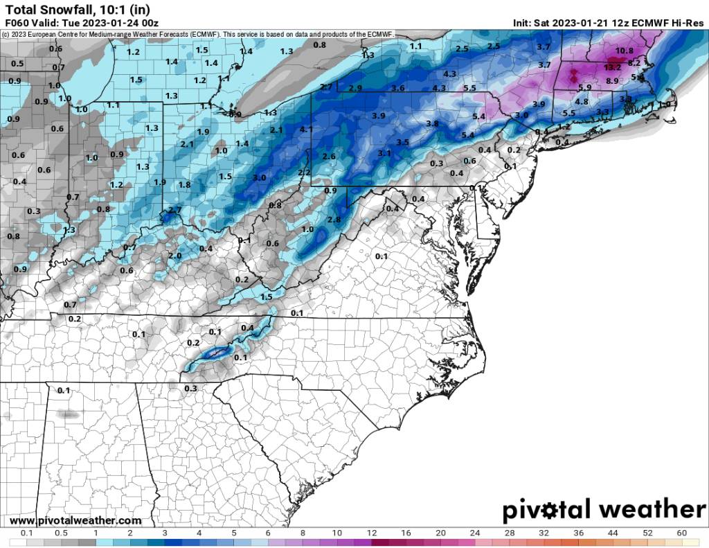
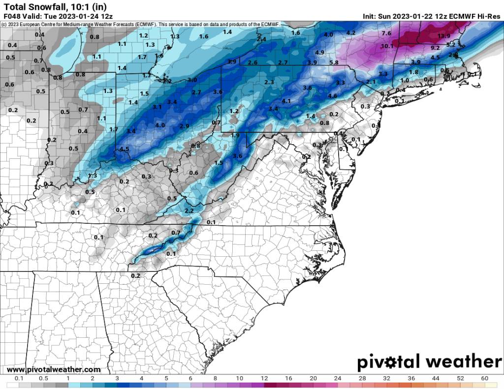
The is the 12z euro at hour 60. Sent from my SM-G998U using Tapatalk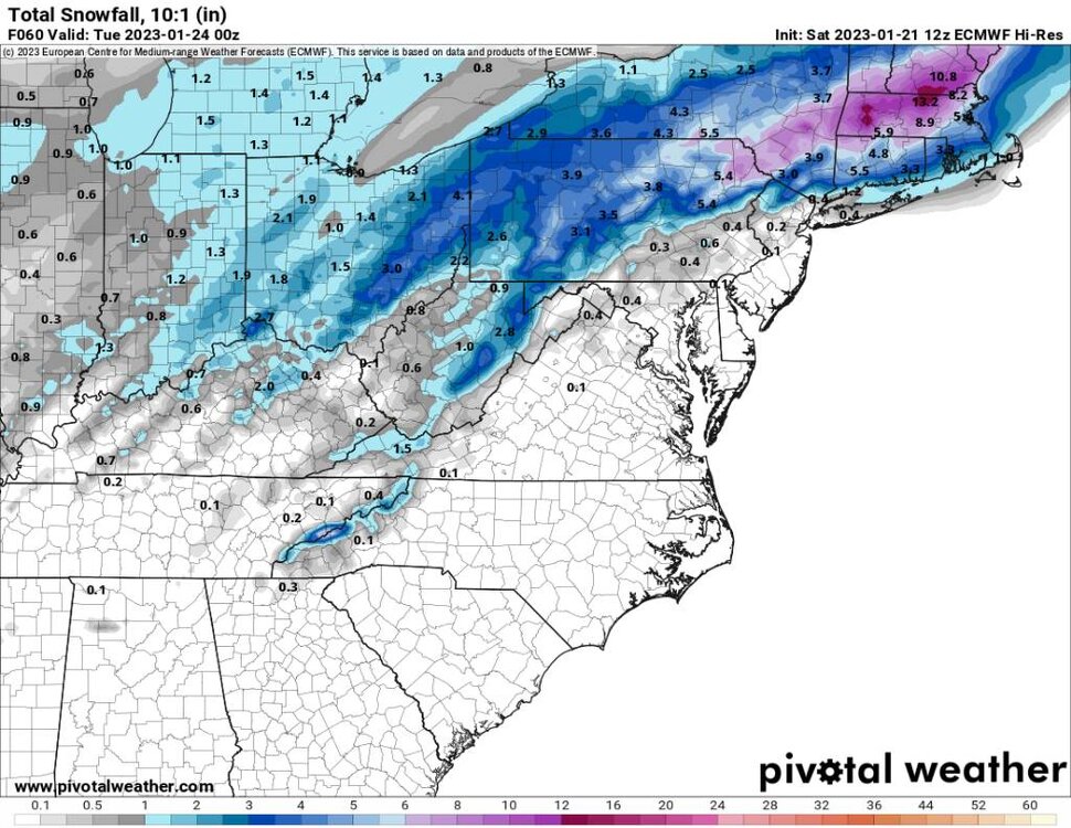
-
2022-2023 Fall/Winter Mountains Thread
Met1985 replied to BlueRidgeFolklore's topic in Southeastern States
00z NAM is a nice hit for the mountains. Sent from my SM-G998U using Tapatalk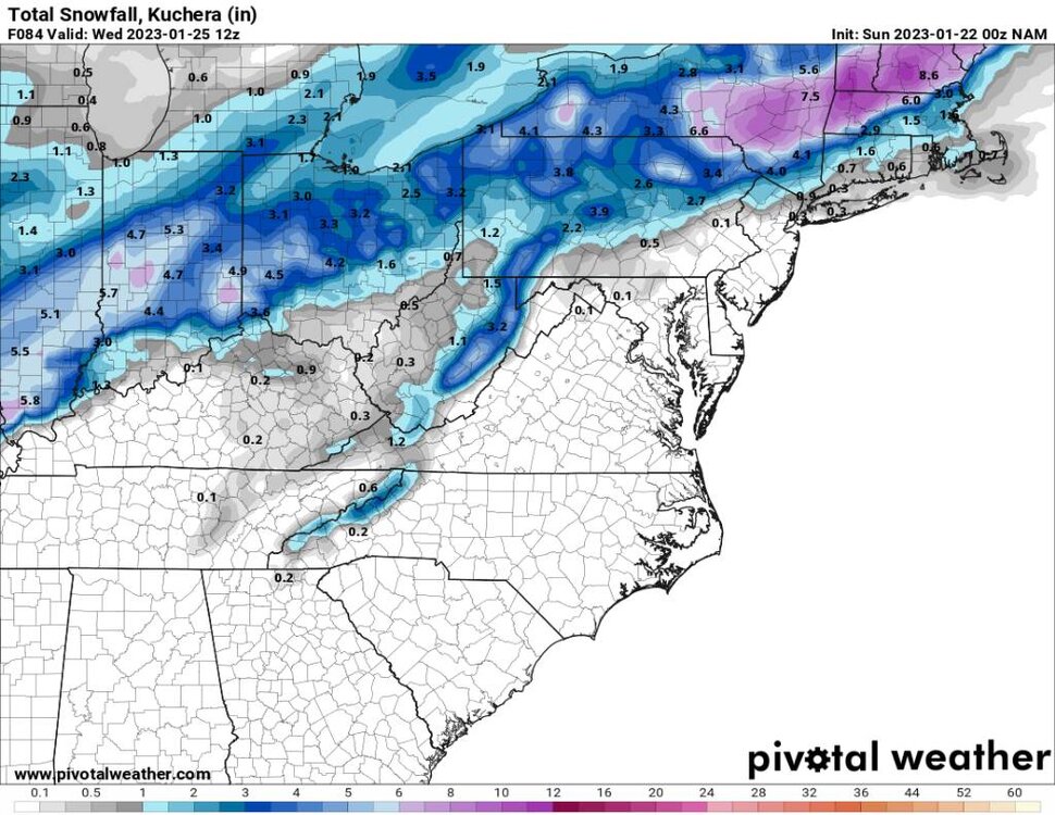
-
2022-2023 Fall/Winter Mountains Thread
Met1985 replied to BlueRidgeFolklore's topic in Southeastern States
The SE ridge is relentless on todays maps. That and diving systems down to the four corners doesn't do us any good.

.jpg.8f0a3f8f31858b272957c1e2cae222da.jpg)

.jpg.75cc81ff0cc34ba444c8674c6875044d.jpg)