Met1985
-
Posts
15,295 -
Joined
-
Last visited
Content Type
Profiles
Blogs
Forums
American Weather
Media Demo
Store
Gallery
Everything posted by Met1985
-

2022-2023 Fall/Winter Mountains Thread
Met1985 replied to BlueRidgeFolklore's topic in Southeastern States
We will take it! -
2022-2023 Fall/Winter Mountains Thread
Met1985 replied to BlueRidgeFolklore's topic in Southeastern States
Snowfall map and still snowing at range on the 00z NAM. Sent from my SM-G998U using Tapatalk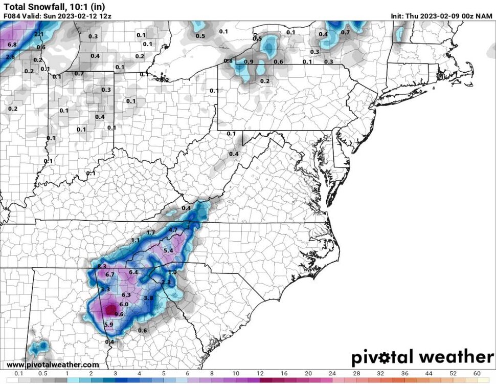
-
2022-2023 Fall/Winter Mountains Thread
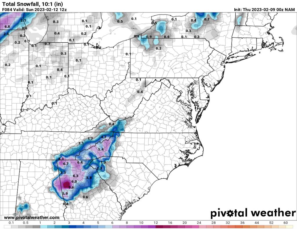
Met1985 replied to BlueRidgeFolklore's topic in Southeastern States
Nam at hour 84. Sent from my SM-G998U using Tapatalk.thumb.jpg.03159aeb9bf330ddf6a7391e83cb89a6.jpg)
-
2022-2023 Fall/Winter Mountains Thread
Met1985 replied to BlueRidgeFolklore's topic in Southeastern States
Nam at hour 81. Sent from my SM-G998U using Tapatalk.thumb.jpg.46aa17a85fbf87624a39f08467b3bb7b.jpg)
-
2022-2023 Fall/Winter Mountains Thread
Met1985 replied to BlueRidgeFolklore's topic in Southeastern States
Nam at hour 78. Sent from my SM-G998U using Tapatalk.thumb.jpg.f7b9b9f5dbc492f3ee021a6e533ac0ca.jpg)
-
2022-2023 Fall/Winter Mountains Thread
Met1985 replied to BlueRidgeFolklore's topic in Southeastern States
O0z NAM at hour 75. Sent from my SM-G998U using Tapatalk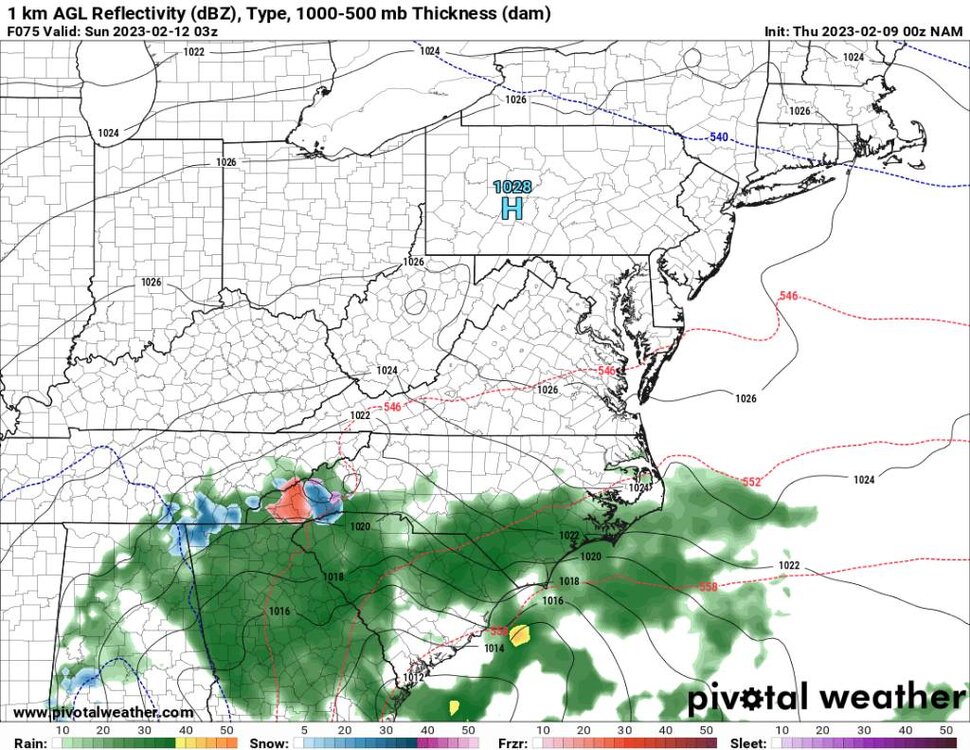
-
2022-2023 Fall/Winter Mountains Thread
Met1985 replied to BlueRidgeFolklore's topic in Southeastern States
Once we get into tomorrow evening and Friday morning we really want all models honed in on this but dealing with a bowling ball ull is going to be tricky especially cut off from the flow. -
Good stuff. Keep us updated about it. It's been very interesting following your posts about this major SSW.
-
How do things look currently with the SSW?
-
2022-2023 Fall/Winter Mountains Thread
Met1985 replied to BlueRidgeFolklore's topic in Southeastern States
The ens doesn't even support the op with where the heaviest snowfall was shown. Im highly suspect of any measurable snowfall outside the mountains. -
2022-2023 Fall/Winter Mountains Thread
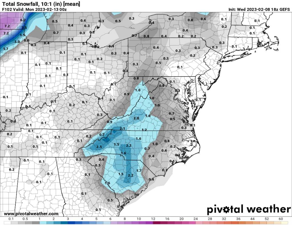
Met1985 replied to BlueRidgeFolklore's topic in Southeastern States
18z gfs ens snow mean. Still not bad with such a shit run. Sent from my SM-G998U using Tapatalk
-
2022-2023 Fall/Winter Mountains Thread
Met1985 replied to BlueRidgeFolklore's topic in Southeastern States
This is funny considering it is the gfs. It finds the storm then goes off the rails lol. -
2022-2023 Fall/Winter Mountains Thread
Met1985 replied to BlueRidgeFolklore's topic in Southeastern States
18z gfs snowmap Sent from my SM-G998U using Tapatalk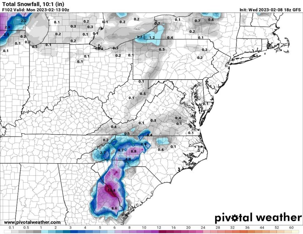
-
2022-2023 Fall/Winter Mountains Thread
Met1985 replied to BlueRidgeFolklore's topic in Southeastern States
Lol congrats middle Georgia and South Carolina. -
2022-2023 Fall/Winter Mountains Thread
Met1985 replied to BlueRidgeFolklore's topic in Southeastern States
Dang it is isn't it. Nice catch. -
2022-2023 Fall/Winter Mountains Thread
Met1985 replied to BlueRidgeFolklore's topic in Southeastern States
Yeah no kidding! This is a classic synoptic look for us. We can get big snows from this type setup but it's been years since we've had one roll through that looks like this. -
2022-2023 Fall/Winter Mountains Thread
Met1985 replied to BlueRidgeFolklore's topic in Southeastern States
Hunters video. https://youtube.com/watch?v=9NJU7_fFGUE&si=EnSIkaIECMiOmarE -
2022-2023 Fall/Winter Mountains Thread
Met1985 replied to BlueRidgeFolklore's topic in Southeastern States
Yeah Hunter it's great to see the euro and eps jump on board big time. -
2022-2023 Fall/Winter Mountains Thread
Met1985 replied to BlueRidgeFolklore's topic in Southeastern States
Another damn great trends on the model runs today. We have the cmc, icon, the gfs, GEFS, the euro, and the eps all putting us in a favorable situation this weekend. And this is all under 4 days now. -
2022-2023 Fall/Winter Mountains Thread
Met1985 replied to BlueRidgeFolklore's topic in Southeastern States
Yeah by this for sure but im very suspect of any great snowfall outside the mountains. -
2022-2023 Fall/Winter Mountains Thread
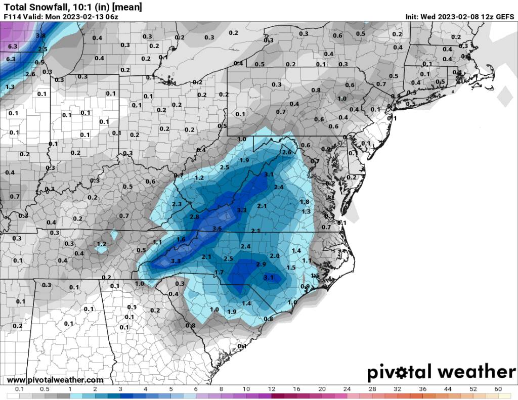
Met1985 replied to BlueRidgeFolklore's topic in Southeastern States
The 12z gefs snowfall means looks good for the mountains. Sent from my SM-G998U using Tapatalk
-
2022-2023 Fall/Winter Mountains Thread
Met1985 replied to BlueRidgeFolklore's topic in Southeastern States
Oh yeah for sure. I think a general 4 to 8 inches across the region and people would be happy with that. -
2022-2023 Fall/Winter Mountains Thread
Met1985 replied to BlueRidgeFolklore's topic in Southeastern States
Yeah we sit in a better spot for sure. You'll probably be on the line on big snow or slop but in the valley or flat lands I don't see it. -
Yeah I just posted the cmc snow map and it gets yall involved and to me a more realistic look at this point. I think it does slow especially when turning negative tilt.
-
2022-2023 Fall/Winter Mountains Thread
Met1985 replied to BlueRidgeFolklore's topic in Southeastern States
Realistically I see the cmc working out much more than I do the gfs. I really don't see down East getting that much snow with marginal temps outside the foothills.

.jpg.2ffb30d8c2f00361d4e4a998c622170f.jpg)
.jpg.e7b4bc81a212209751e27ad0d9be5462.jpg)
.jpg.5cd7c59e6a3347685f087bfb467405a4.jpg)