Met1985
-
Posts
15,295 -
Joined
-
Last visited
Content Type
Profiles
Blogs
Forums
American Weather
Media Demo
Store
Gallery
Everything posted by Met1985
-

2022-2023 Fall/Winter Mountains Thread
Met1985 replied to BlueRidgeFolklore's topic in Southeastern States
Yeah getting our first frozen precipitation with a moderate sleet and snow mixture. -
2022-2023 Fall/Winter Mountains Thread
Met1985 replied to BlueRidgeFolklore's topic in Southeastern States
Humidity is going down and dp is going down. Really at this point it's nowcast time and whatever happens, happens. -
2022-2023 Fall/Winter Mountains Thread
Met1985 replied to BlueRidgeFolklore's topic in Southeastern States
We are getting a lot of virga currently and it's still pretty dry. This is going to be razor thin but I think we can pull it out. -
2022-2023 Fall/Winter Mountains Thread
Met1985 replied to BlueRidgeFolklore's topic in Southeastern States
18z nam with an uptick in snowfall a bit. Sent from my SM-G998U using Tapatalk.thumb.jpg.7ac828272fe3dce63b2353b4c7ff3b1b.jpg)
-
2022-2023 Fall/Winter Mountains Thread
Met1985 replied to BlueRidgeFolklore's topic in Southeastern States
This is a big improvement from the 00z suite. -
2022-2023 Fall/Winter Mountains Thread
Met1985 replied to BlueRidgeFolklore's topic in Southeastern States
One positive thing I saw last night and this morning was we went from 66 to 31 this morning all under cloudy skies. So it can be done with the right thermals. We will see. -
It's decaying fast. I've read where we may have a nino like spring. Which would delay a true spring.
-
2022-2023 Fall/Winter Mountains Thread
Met1985 replied to BlueRidgeFolklore's topic in Southeastern States
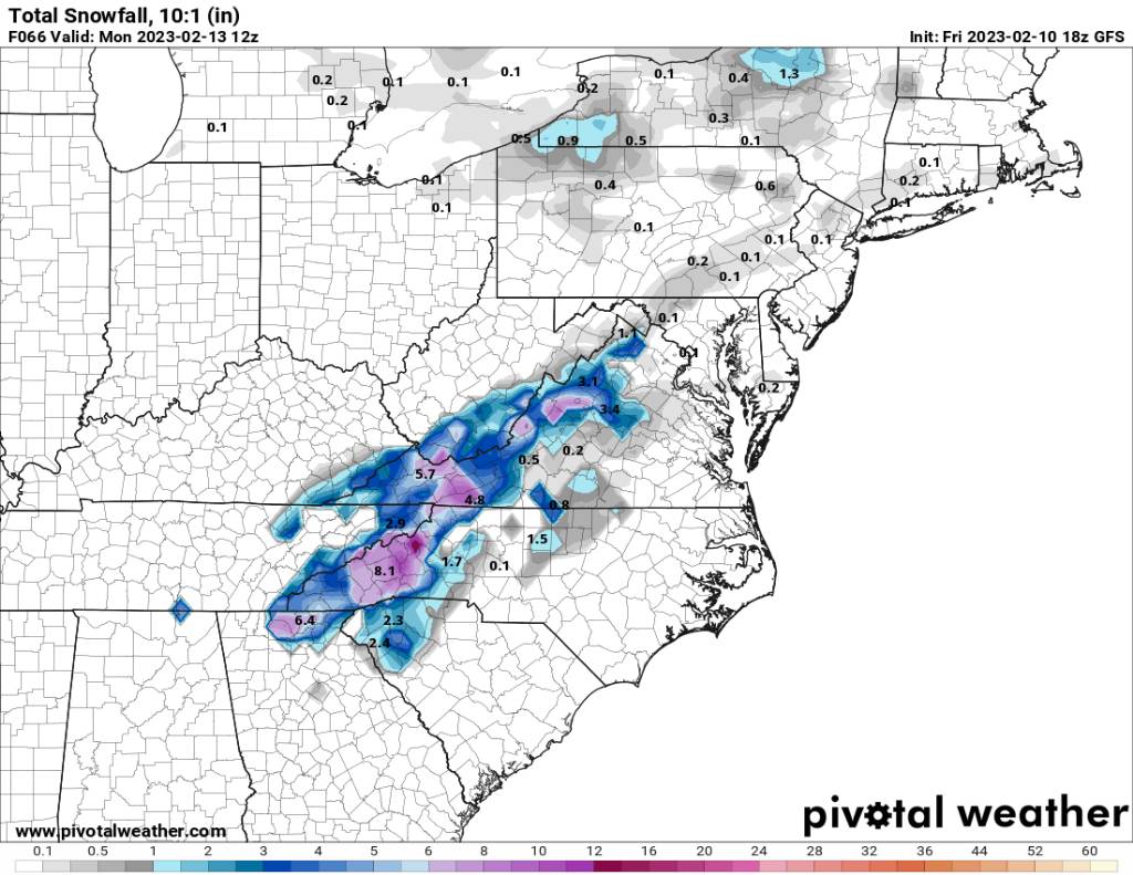
12z gfs snowfall map. This run was a bit of improvement. Sent from my SM-G998U using Tapatalk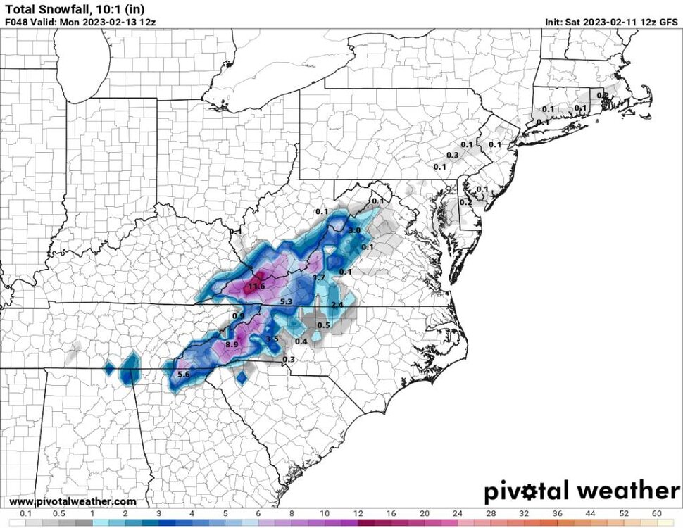
-
2022-2023 Fall/Winter Mountains Thread
Met1985 replied to BlueRidgeFolklore's topic in Southeastern States
06z nam likes ice. Sent from my SM-G998U using Tapatalk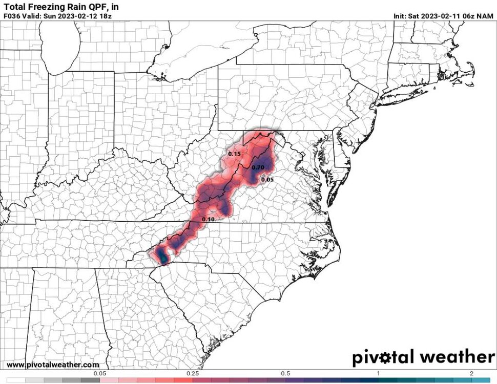
-
2022-2023 Fall/Winter Mountains Thread
Met1985 replied to BlueRidgeFolklore's topic in Southeastern States
Might be. I think we still see corrections into tomorrow. -
2022-2023 Fall/Winter Mountains Thread
Met1985 replied to BlueRidgeFolklore's topic in Southeastern States
00z gfs snowfall map. Sent from my SM-G998U using Tapatalk.thumb.jpg.b4e9b336f18975dad6c1f98b9f5873e0.jpg)
-
2022-2023 Fall/Winter Mountains Thread
Met1985 replied to BlueRidgeFolklore's topic in Southeastern States
The poor ol 00z NAM snowfall Sent from my SM-G998U using Tapatalk.thumb.jpg.eb78a7c3d7dfa1d3b60437468419677e.jpg)
-
2022-2023 Fall/Winter Mountains Thread
Met1985 replied to BlueRidgeFolklore's topic in Southeastern States
Hunters video. -
2022-2023 Fall/Winter Mountains Thread
Met1985 replied to BlueRidgeFolklore's topic in Southeastern States
Hunter is a great forecaster and even better person. Having spent some time with Hunter and lots of Communication he is a true professional. -
2022-2023 Fall/Winter Mountains Thread
Met1985 replied to BlueRidgeFolklore's topic in Southeastern States
Yeah might as well give everyone a heart attack while we are at it.... -
Fascinating Larry! And you can definitely see the big shift in the last two from very warm to absolutely frigid. I really think that is where we are headed especially with the favorable mjo coming along towards the end of this month. Great stuff again! Im definitely looking forward to seeing how all this plays out.
-
2022-2023 Fall/Winter Mountains Thread
Met1985 replied to BlueRidgeFolklore's topic in Southeastern States
We may actually see a correction with tonight's models and tomorrow morning for a more favorable look. -
2022-2023 Fall/Winter Mountains Thread
Met1985 replied to BlueRidgeFolklore's topic in Southeastern States
18z gfs snowfall map. A much better improvement over the 12z. Sent from my SM-G998U using Tapatalk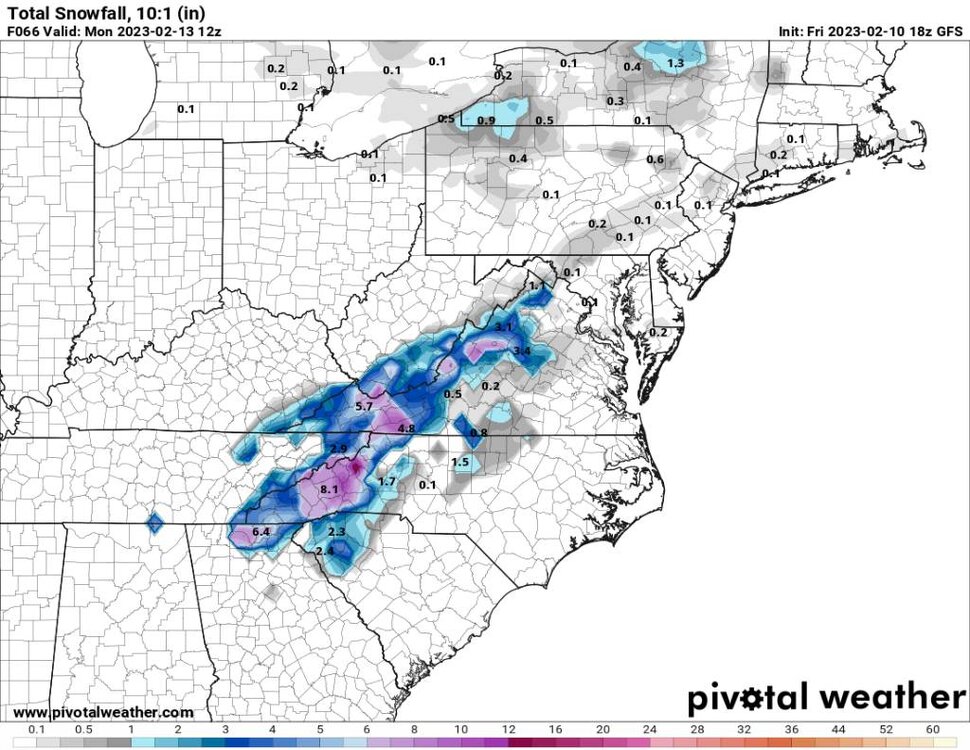
-
2022-2023 Fall/Winter Mountains Thread
Met1985 replied to BlueRidgeFolklore's topic in Southeastern States
Yall can bail anytime yall want to but im still optimistic about everything especially for us mountain folk. The foothills is a different story and may I remind you the NAM has had issues recently with snowfall and with accumulations. -
2022-2023 Fall/Winter Mountains Thread
Met1985 replied to BlueRidgeFolklore's topic in Southeastern States
Avery-Madison-Yancey-Mitchell-Swain-Haywood-Buncombe-Graham- Northern Jackson-Macon-Southern Jackson-Transylvania-Henderson- Caldwell Mountains-Burke Mountains-McDowell Mountains- Including the cities of Ingalls, Banner Elk, Newland, Faust, Mars Hill, Marshall, Walnut, Allenstand, Hot Springs, Luck, Swiss, Burnsville, Celo, Micaville, Ramseytown, Busick, Spruce Pine, Poplar, Alarka, Almond, Bryson City, Luada, Wesser, Waynesville, Waterville, Canton, Cruso, Cove Creek, Asheville, Black Mountain, Candler, Robbinsville, Stecoah, Cullowhee, Tuckasegee, Sylva, Franklin, Rainbow Springs, Kyle, Highlands, Wolf Mountain, Cashiers, Brevard, Cedar Mountain, Little River, Hendersonville, Fletcher, Dana, East Flat Rock, Tuxedo, Etowah, Jonas Ridge, Ashford, Woodlawn, and Old Fort 234 PM EST Fri Feb 10 2023 ...WINTER STORM WATCH IN EFFECT FROM SATURDAY EVENING THROUGH SUNDAY EVENING... * WHAT...Heavy mixed precipitation possible. Total snow and sleet accumulations of 4 to 10 inches and ice accumulations of a light glaze possible. Winds could gust as high as 40 mph. * WHERE...The North Carolina mountains. * WHEN...From Saturday evening through Sunday evening. -
Great stuff Larry! I love your updates on this. Keep them coming brother. Thank you.
-
2022-2023 Fall/Winter Mountains Thread
Met1985 replied to BlueRidgeFolklore's topic in Southeastern States
12z eps mean is not bad still. Sent from my SM-G998U using Tapatalk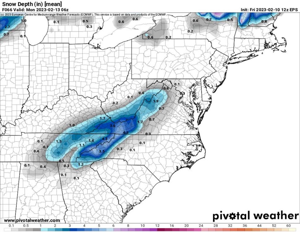
-
2022-2023 Fall/Winter Mountains Thread
Met1985 replied to BlueRidgeFolklore's topic in Southeastern States
Could be but I mean even 2 to 4 inches is a win for most this winter. I still think the foothills are very very borderline. -
2022-2023 Fall/Winter Mountains Thread
Met1985 replied to BlueRidgeFolklore's topic in Southeastern States
This thing can obviously change course and just a few miles difference will mean a lot to the snow totals and who sees snow. This is far from over in my opinion. Like I said the euro isn't that bad.

.jpg.92afe8ed37f3288492bcbe3a8c5e008b.jpg)


.jpg.3958a27610334c53d7339dd6f33fa77a.jpg)
.jpg.19e33c776b9bf08bd27e17c27a33feb9.jpg)