NC_hailstorm
-
Posts
2,593 -
Joined
-
Last visited
Content Type
Profiles
Blogs
Forums
American Weather
Media Demo
Store
Gallery
Everything posted by NC_hailstorm
-
Mid to Long Term Discussion 2019
NC_hailstorm replied to Upstate Tiger's topic in Southeastern States
Looks like the 12z Ukie is bringing that cutoff energy in the SW through here around day 6. Low right through the upstate of SC with good rain totals,0z Euro cuts the low through Ohio with rain as well. -
Looking Ahead to Fall and Winter
NC_hailstorm replied to Iceagewhereartthou's topic in Southeastern States
MJO re emerging in the W.Pacific right on time(Nov.11-16th)with a big Arctic front entering the eastern US.Still think it keeps moving till around Nov.28th-Dec.4th into phase7,8,1,2 but as low as the solar wind has been this cycle I'd lean closer to early December but we'll see. MJO should stall,weaken.or move to Maritime around Nov.28th-Dec.4th.There may be a relaxing of the pattern around and a bit after then then but the MJO should re emerge around Dec.6th-Dec.12th.December can be tricky if we get unexpected solar wind flareups like last year which in my opinion locked up the MJO in a warm phase longer than expected. Also I'm watching the QBO closely,if that flips let's just say watch out. Just my opinion. -
Temps thru Nov.10th.Cold month so far and what's more shocking is CLT NOT in the lead for the first time in 6 months. GSP -6.0 HKY -6.2 AVL -4.6 RDU -5.3 GSO -5.2 CAE -4.5 CLT -4.7
-
Good job Grit,I enjoy reading your analysis and opinions.
-
Mid to Long Term Discussion 2019
NC_hailstorm replied to Upstate Tiger's topic in Southeastern States
Looks like the Ukie is going for a coastal Friday/Saturday.Cutoff looks around I-85 south but that looks cold and wet if it's right. GFS has nothing,. -
Looking Ahead to Fall and Winter
NC_hailstorm replied to Iceagewhereartthou's topic in Southeastern States
MJO moving into Maritime right on time(Nov.2nd-Nov 7th)with a slight stall forecasted.Still think it emerges sometime Nov.11th-Nov.16th I'm leaning closer to Nov.11th into the Western Pacific/West.Hem.Warm spell looks brief though this week. When it does come out it should keep moving till around Nov.28-Dec.4th when the next sun/solar wind rotation occurs.Could be a cold month id it's in phase 7,8,1,and 2. Just my opinion. -
Final October temps and no surprise CLT wins again. GSP +4.9 HKY +4.7 AVL +5.1 RDU +4.6 GSO +4.7 CAE +6.0 AND CLT +6.8
-
79.3 with a dp of 70 today,crashing down to 54.8 with a dp of 50 now.Pretty big flip in airmasses in an hour or so.2.43'' storm total from yesterday. Windshields and windows on my truck and car instantly fogged up,I don't think I've seen that except maybe a few times before.
-
Sometimes you just gotta shake your head.Lows this morning for example. GSP 57.2 HKY 57.0 AVL 50.0 RDU 55.0 GSO 59.0 CAE 55.4 AND CLT 64.0
-
Temps thru Oct.20th. GSP +5.2 HKY +4.9 AVL +5.8 RDU +3.7 GSO +4.3 CAE +5.9 AND CLT +6.2
-
Looking Ahead to Fall and Winter
NC_hailstorm replied to Iceagewhereartthou's topic in Southeastern States
My opinion is the MJO will keep moving till sometime around Nov.2nd-Nov.7th and then weaken or move to the Maritime.It should re emerge sometime around Nov.11th-Nov.16th meaning the first half of November might be warmer so we'll see. -
1.85'' here and no water standing anywhere
-
Just looking at the early 0z HRRR,someone is going to get clocked in the Upstate/W.Piedmont/or in Central NC if it's right.Wherever that heavy rain band sets up I see a couple 3''-4'' lollipops in there.
-
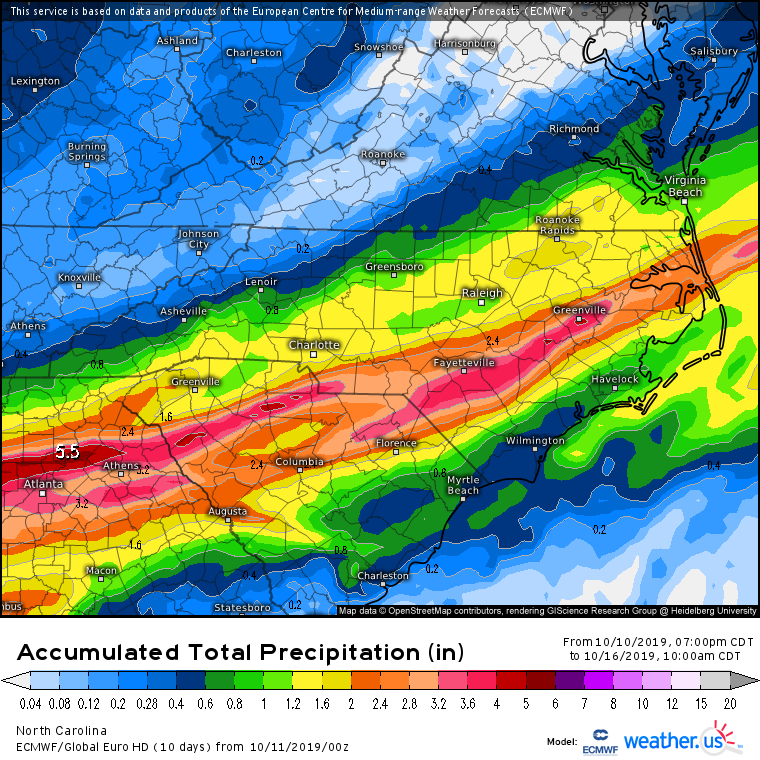
12z Euro looks like the 3km NAM with better rain further NW.GFS and Ukie have that sharp cuttoff around I-85.
-
Mid to Long Term Discussion 2019
NC_hailstorm replied to Upstate Tiger's topic in Southeastern States
12z Ukie is bringing the hammer Sunday for eastern parts of NC/SC.Gulf low right up the coast.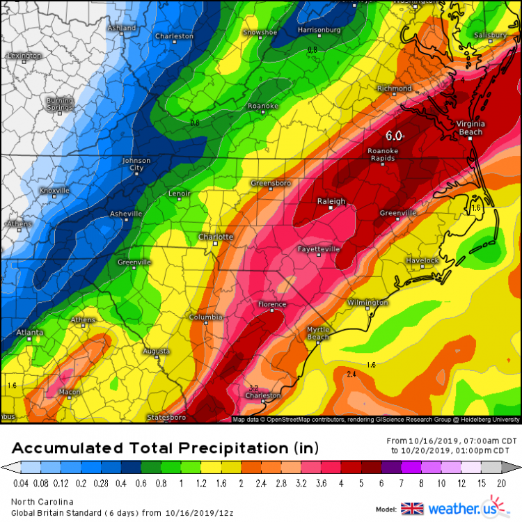
-
Mid to Long Term Discussion 2019
NC_hailstorm replied to Upstate Tiger's topic in Southeastern States
Last couple HRRR runs looking better for the GSP -CLT-GSO-RDU corrider putting down .75'' -1.00'' in 8 to 18 hours.Sharp cutoff on both sides with only a few tenths so we'll see how it goes. -
October temps thru the first 10 days,and look at that CLT in the lead as usual. GSP +9.4 HKY +9.3 AVL +9.7 RDU +7.8 GSO +8.5 CAE +10.0 AND CLT +11.0
-
Mid to Long Term Discussion 2019
NC_hailstorm replied to Upstate Tiger's topic in Southeastern States
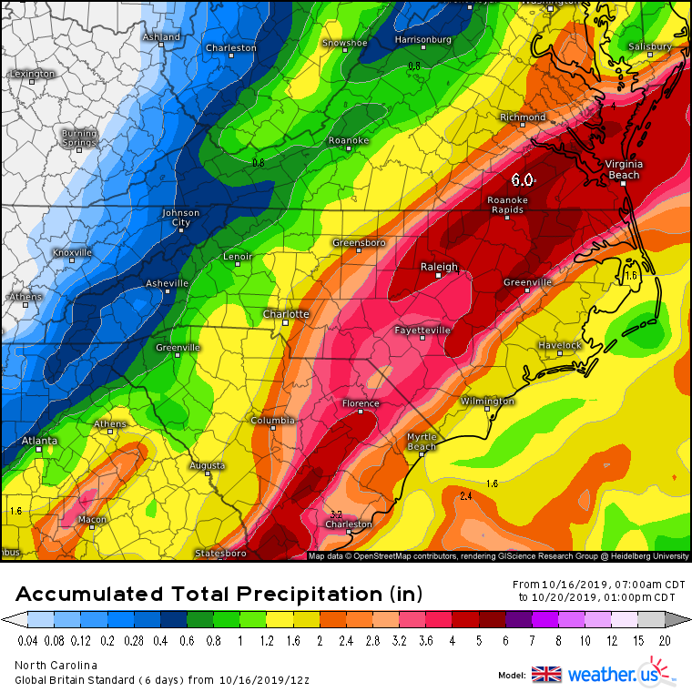
12z Euro delivers,ticking totals further NW.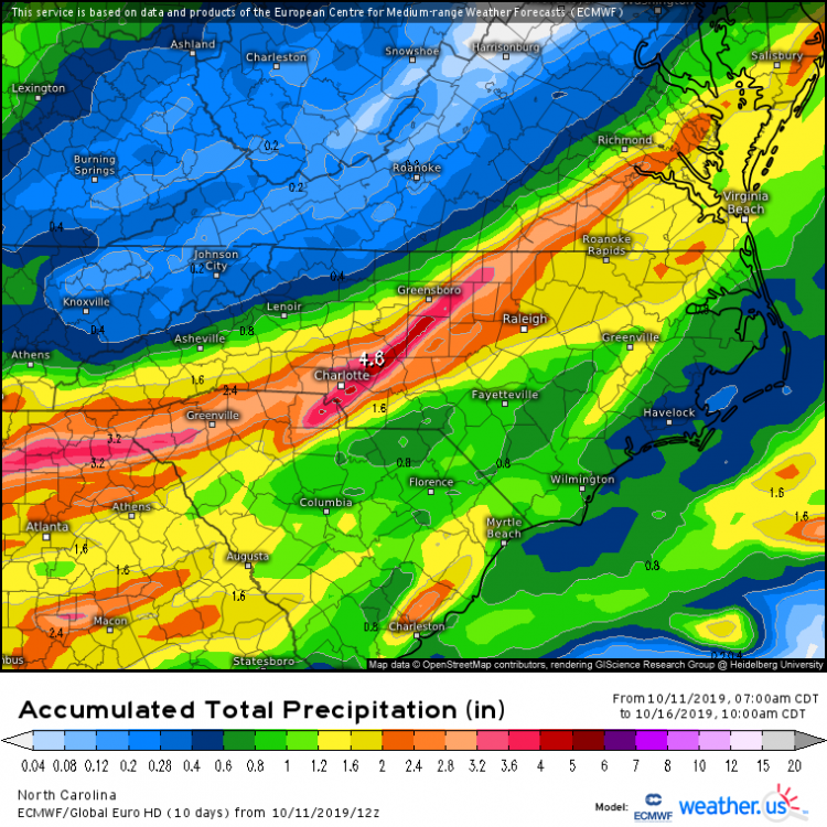
-
Mid to Long Term Discussion 2019
NC_hailstorm replied to Upstate Tiger's topic in Southeastern States
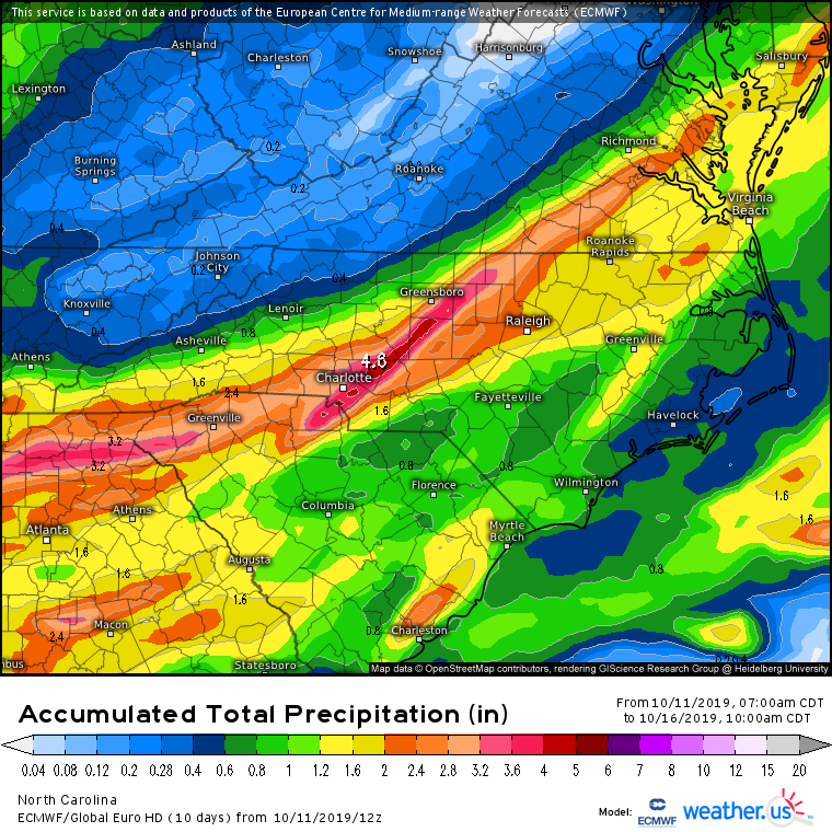
Euro at day 5/6 looks better today but we need a couple more ticks NW to get the mountains/foothills a little more.Let's hope this chance works out this time.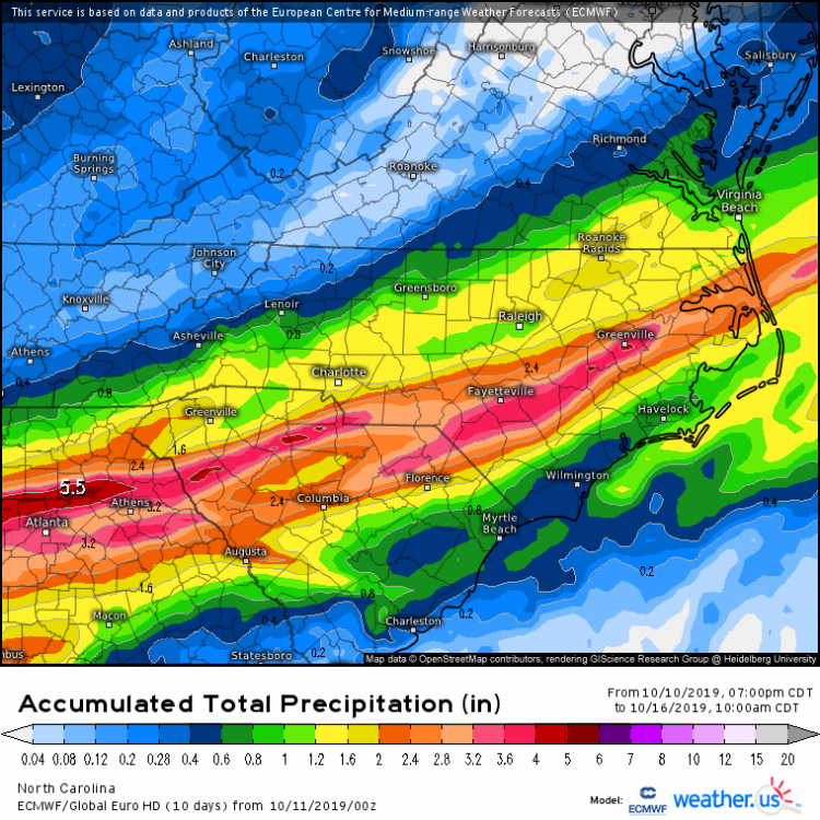
-
A warm 30 days in September is gonna skew the numbers for the summer..GSP for example for JJA. GSP June -0.8 July +0.3 August -0.1
-
Hot month but CLT wins the hottest spot on the planet again. GSP +7.1 HKY +6.7 AVL +7.2 RDU +4.9 GSO +6.2 CAE +6.2 AND CLT +7.9
-
Renegade t-shower somehow came over this evening. 0.36''
-
Mid to Long Term Discussion 2019
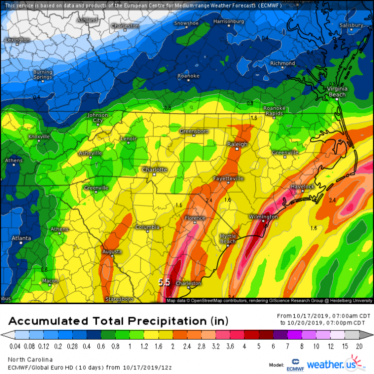
NC_hailstorm replied to Upstate Tiger's topic in Southeastern States
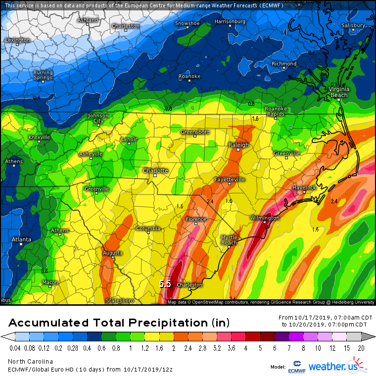
Best looking precip map I've seen in about 6 or 7 weeks,Euro gets wetter after day 7 dropping in a strong shortwave and lowering the heights.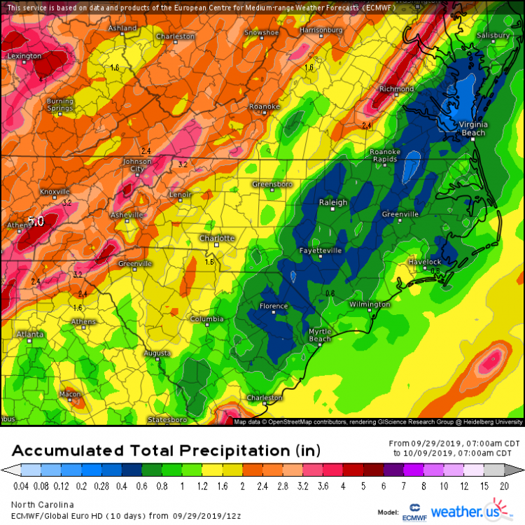
-
Hot month,CLT still in the lead as usual. GSP +5.6 HKY +5.5 AVL +6.0 RDU +3.2 GSO +4.8 CAE +4.6 AND CLT +6.6
-
Looking Ahead to Fall and Winter
NC_hailstorm replied to Iceagewhereartthou's topic in Southeastern States
I would also watch the the gulf stream very closely and the AMOC(Atlantic Meridional Overturning Circulation)This has been a hotspot to watch from about Cape Hatteras to Cape Cod maybe a bit further into Canada. Solar minimum weakens the circulation,moving it further south in my opinion.2009-10 is a prime example to what to look for and QBO flipped to negative halfway through that year.Cut off the gulf stream and you most likely get colder. http://www.ccpo.odu.edu/~tezer/PAPERS/2015_GPC_AMOC_SL.pdf