

NC_hailstorm
-
Posts
2,593 -
Joined
-
Last visited
Content Type
Profiles
Blogs
Forums
American Weather
Media Demo
Store
Gallery
Everything posted by NC_hailstorm
-
20.5 here this morning Some monthly temps for the region,guess who's still above average. GSP -1.3 HKY -0.7 AVL -0.8 RDU -0.2 GSO -0.8 FAY -0.2 CAE -1.3 CLT +0.7
-
Little chilly this morning,14.4 for a low.
-
Front just arrived here,howling winds all of a sudden from the WNW.Good 8 degree drop in about 15 or 20 minutes.
-
Canadian looks similar at that range so Euro is not alone.. Watch that shortwave diving in the 4 corners area around day 7/8.
-
GFS still going for that SSW in the long range,the attack begins today or tomorrow with higher solar input. When and if it occurs you have to watch where that PV sets up .You don't want that getting stuck in central,SW Canada that happened a few years ago and hurt more than helped and I'm talking about down at 100hpa levels. Just my opinion.
-
Ice Time? Dec. 16ish Possible CAD Event
NC_hailstorm replied to Tar Heel Snow's topic in Southeastern States
Lights out for me. -
November’s AMO index saw a sharp decline to 0.125. Good sign for AO/NAO but hasn't been negative since December 2018 and we know what happened then.Also some warmer water showing up around Greenland. Get another attack on the Polar Vortex starting Dec.20th in my opinion.
-
Well the most important thing is....Who's gonna start the thread?
-
Looks right it is forecasted to push to 100mb.Everything I read is you want easterly at 30mb maybe he wants it at 100mb too.
-
Anyways,my two cents on winter.Good and Bad. Good: There's always a 3 to 4 year lag on low solar/sunspots so just coming into that,blocking Ascending phase of the solar cycle,blocking QBO-Bad now could be good soon very deceiving only a small patch of westerlies is at the equator with EQBO forecasted to push down to 30mb.Weakens PV.blocking. BAD ENSO- La Lina Usually southeast ridging .west trough. Gulf Stream-Tick better than last year but still not good.Looking for colder waters from Newfoundland/Nova Scotia/down to NC,Warm around Greenland..NAO is what you look at here. About it .
-
Sure come on up get away from all the terrible Mooresville traffic.
-
Looking Ahead to Fall and Winter
NC_hailstorm replied to Iceagewhereartthou's topic in Southeastern States
No need to be a smartass dude with your snarky remarks. Why don't you move along son and let some of us observe and research things while you stare out your window and pray for snow. -
Looking Ahead to Fall and Winter
NC_hailstorm replied to Iceagewhereartthou's topic in Southeastern States
Basically here's what going on(in my opinion) -Notice the lack of any MJO through the Maritime over the last 90-100 days.Low solar/EEPusually equal less Maritime forcing in general.Now you add extremely low solar wind/EEP over 100 days and you get an undisturbed/boiling Maritime.Nobody including me was paying any attention to that too much and this was all solar forced/induced with low solar wind over 3 months. -The best example i can give is throwing a match at the end of a gas leak with a vehicle at the other end about 100 feet,that vehicle will explode in a couple seconds.Same thing going on here the MJO gets close to the warming gets pulled rapidly,way ahead of schedule to the Maritime and explodes.Just file that away for later,use what you learned and be prepared next time. _MJO should still come out Jan 22nd-26th after the rotation around Jan 14th.Whether or not we get strong one to p8 p1 and p2 remains to be seen that feature in the Maritime looks potent and might get another repeat of this last MJO cycle so we'll see. Just my opinion. -
Looking Ahead to Fall and Winter
NC_hailstorm replied to Iceagewhereartthou's topic in Southeastern States
MJO re emerging today right on time (Dec.26th-Jan 1) MJO forecasts are slowly correcting,moving this into p7,p8 and possibly p1,this latest kp3 solar wind shouldn't be enough to get a full transfer to the Maritime in my opinion.Only cracking 400km/s so far,low solar/EEP +GLAMM don't equal Maritime forcing. MJO will stall weaken/stall or get pulled to Maritime around Jan14-Jan 18th though when the next rotation begins,get another relaxing/warming period then or a bit afterwards. Just my opinion. -
Looking Ahead to Fall and Winter
NC_hailstorm replied to Iceagewhereartthou's topic in Southeastern States
Pretty sure I see the culprit on why these MJO forecasts are trying to stall/loop/Maritime. There's now a forecast of kp3(elevated solar wind/EEP) for 12/25 12/26 and 12/27 that was NOT there three days ago.Any extra solar wind/EEP will try to stall and loop the MJO into Maritime,and given the 4-8 day lag that's why its trying to loop it around Jan 1st-5th. Depending how strong this is will determine whether or not we get a cold first half of January in my opinion,anything over 500km/s for 3 days won't be good either.Seeing as a relaxing period is coming Jan14th- Jan.18th anyway because of the regular rotation it will be Jan.22nd -Jan.26th before the MJO reemerges. Just my opinion. -
Looking Ahead to Fall and Winter
NC_hailstorm replied to Iceagewhereartthou's topic in Southeastern States
MJO weakening and entering the COD right on time (Dec.18th-Dec.22nd)and entering the relaxing/warming period .Everything looks on schedule to me. Still think the MJO reemerges around Dec.26th-Jan.1st ,getting a short/weak rotation so far only a 4 day event with kp4 levels and solar wind/EEP only cracking 550km/s nothing to stall it or loop it in my opinion.GLAMM and torque should respond as the forcing moves back equatorially. It might sneak into p6 but this should enter p7 rapidly and keep moving(p8 p1) till around Jan.14th when the next rotation begins.Then we get another relaxing/warmer period(5-7 days) around and after then. Just my opinion. -
Temps through 12/13.Couple really warm days (12/1 and 12/10) keeping temps closer to average. GSP -0.6 HKY 0.0 AVL +1.1 RDU -0.2 GSO -1.2 CAE +1.3 CLT +1.2
-
Looking Ahead to Fall and Winter
NC_hailstorm replied to Iceagewhereartthou's topic in Southeastern States
Euro seasonal looks better today,this updates every 13th day of the month.Much better blocking showing up south of Alaska now,.Heights across the lower 48 much lower this was all in the 40%-50%-50%-60% above average(light/moderate yellow) in November.Better heights in Greenland this was all mostly 40%-50% below average(light blue) in November as well.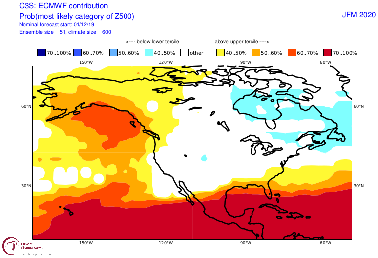
-
Looking Ahead to Fall and Winter
NC_hailstorm replied to Iceagewhereartthou's topic in Southeastern States
Just looking at the Euro/Berlin strat site,I see the QBO forecast to switch to easterly in 5-7 days at 30hpa at the equator.That's pretty significant. Sooner the better because it's going to take a while to bust up that strong PV that's running pretty strong at the moment,least a month or so to feel any effects. -
Looking Ahead to Fall and Winter
NC_hailstorm replied to Iceagewhereartthou's topic in Southeastern States
MJO re emerging In phase 2 today and right on time(Dec.6th-Dec.12th).Should continue there till around Dec.18th-Dec.22nd if we get a short lag time.Weakens or a pull to Maritime and we get a brief relaxing of the pattern afterwards. MJO should reemerge around Dec.26th-Jan.1st if we get the short lag time,pattern reloads but these lag times are getting shorter because in my opinion of very,very,low solar wind?EEP and shorter/weaker CME rotations.I counted 5 days this week where it went below 300km/s. Just my opinion. -
Mid to Long Term Discussion 2019
NC_hailstorm replied to Upstate Tiger's topic in Southeastern States
Euro has a strong shortwave moving into N.California/S.Oregon at day 4. Into S.Arizona/N. Mexico at day 6 then into W.Texas at day 7 which produces the gulf low. Ukie has this piece at day 3/4 but looks more sheared out as it moves south.Whether or not it runs right into a 1043 high remains to be seen but something to track. -
Looking Ahead to Fall and Winter
NC_hailstorm replied to Iceagewhereartthou's topic in Southeastern States
Looks like the MJO is struggling to push into phase 3 by Dec.15th just looking at the latest forecasts which make sense in my opinion.This latest solar wind/CME/ sun rotation exited on 11/28 meaning low solar wind,+GLAMM are returning now.This should continue till December 18th when the next high solar wind/CME rotation comes in and weakens the MJO or pushes it to Maritime after the 18th. Phase 1 and 2 are colder for Eastern US in December,low solar/EEP +GLAMM don't equal Maritime forcing or Indian forcing so I'd be very cautious throwing out big December warmups at least through Dec.18th. +GLAMM/low solar/EEP into an El Nino promotes blocking as well,you could easily get 7-10 days of some sort blocking in between solar rotations in my opinion.The QBO is a whole different matter, stratospheric anomalies tend to be transmitted down to the troposphere during an easterly QBO rather more than a westerly one. Strong research that -QBO with low solar promote blocking as well. Just my opinion. -
Looking Ahead to Fall and Winter
NC_hailstorm replied to Iceagewhereartthou's topic in Southeastern States
Lot of these experts or so called experts like using and looking at Global Angular Momentum( GLAMM),Mountain torque(MT),and Global Wind Oscilation(GWO).These are all fine to use but in my opinion the solar wind/EEP/CME/sun rotation drive all these ultimately.Most people don't even know what these are so Ill try. -GLAMM is a measure of the turning force of the winds and it oscialltes up and down.When its high its called +GLAMM when low its called -GLAMM. - Torques make up significant parts of the momentum as well. They are large drivers in tendency in angular momentum helping to remove or add winds to the atmosphere. - Rising GLAAM is better for promoting a disrupted flow pattern which is supportive of higher latitude blocking in winter..Blocking is more likely during El Nino (+GLAAM) .Seasonlly dependent though -GLAMM in summer promtes blocking. - Tropical forcing is very significant as this is a major driver in global momentum. (MJO) Low solar wind/EEP pushes the Hadley cells Equatorially(+GLAMM into the MJO) High solar wind/EEP pushes the Hadley cells to the Polar regions(-GLAMM weakens the MJO) Anyone notice the GWO and GLAMM completely dropped out at the beginning of September and the MJO completely locked up?Isn't a coincidence the solar wind/EEP roared to life then hitting 872km/s .The next rotation hit in late September and kept it knocked down. Anyone notice it shoot straight upwards around Oct,10th and still high now?Isn't it another coincidence the solar wind/EEP dropped out below 300-350lm/s for weeks. It don't take a rocket scientist to figure out when you hear terms like Angular momentum,Torque,and Global Wind what's really going on here. Carry on. -
Looking Ahead to Fall and Winter
NC_hailstorm replied to Iceagewhereartthou's topic in Southeastern States
MJO weakening and crawling in the COD(Nov.28th-Dec.4th),right on time to me.No full pull to the Maritime because in my opinion the solar wind /CME rotation running real low. this cycle.Pattern relaxing as expected as i see a 594dm death ridge parked over S.Florida and most of the Gulf of Mexico this morning.Lag times have been real short with this cycle,almost cut in half so it might try to sneak out earlier than expected(Dec.6th-Dec-12th)so we'll see. It should come out and move till around Dec.26th,-Jan.1st but if the lag times continue to shorten everything gets moved up(Dec.22nd-Dec.28th).My opinion is the whole solar wind field has been extremely low since about Oct.10th and the CME rotations have been much weaker. Dec.8th could be pivotal as a CME is forecasted to arrive.this could lock up the MJO if its strong and lasts a few days. Just my opinion. -
Temps thru Nov.20th,cold month so far. GSP -6.2 HKY -6.2 AVL -4.1 RDU -6.6 GSO -6.4 CAE -6.4 CLT -5.1

