NC_hailstorm
-
Posts
2,593 -
Joined
-
Last visited
Content Type
Profiles
Blogs
Forums
American Weather
Media Demo
Store
Gallery
Everything posted by NC_hailstorm
-
December 8-10, 2018 Winter Storm
NC_hailstorm replied to Orangeburgwx's topic in Southeastern States
I might save this one.Day 8 Euro.
-
Think I was looking at 12km but yeah you're right.
-
The 18z NAM continues to cut these rainfall totals in NW NC,3''-5'' across there on this run with a big cutoff just SE of CLT where 9'' plus are.Might be a bit light but we'll see. Carry on.
-
GFS has your area right on 6'',higher totals to the southwest
-
GFS cut back on the totals for people in the W.Piedmont/foothills on this last run.The NAM looks similar and is a bit less. It brings heavy rain in around hour 38 and lasts to about hour 56,with lighter rain on either end for a bit so it pours for at least 18 hours. Solid 4''-8'' looks ok right now with isolated 10'' lollipops possible.
-
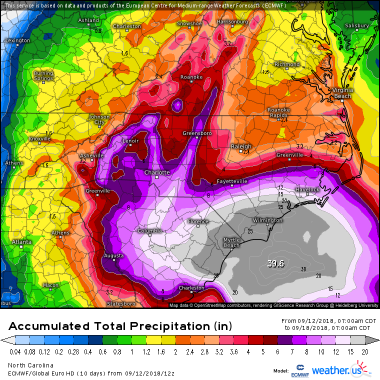
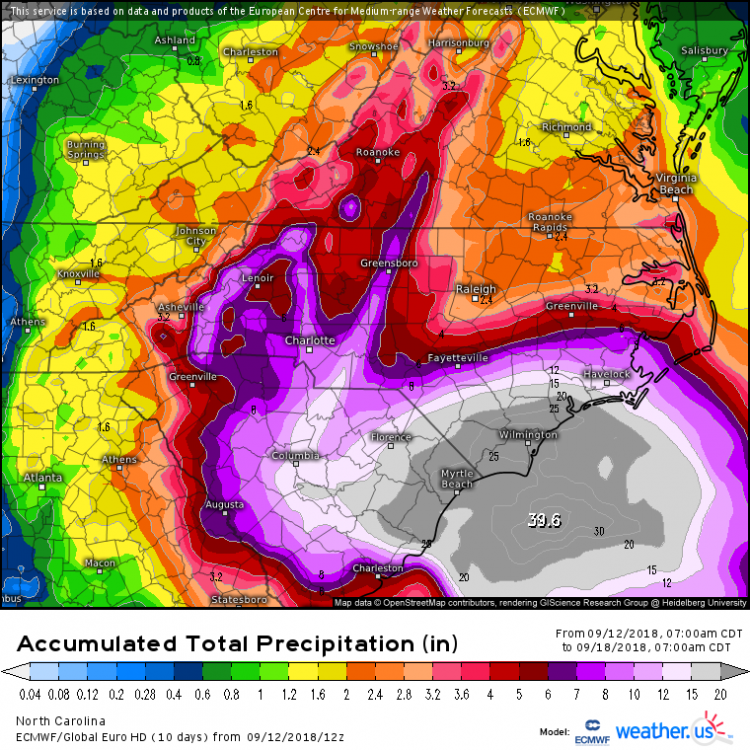
Ukie has been putting down some big totals the last few runs.That's 50'' south of Wilmington. Ukie day 4
-
Euro has a wicked squall line coming through the W.Piedmont/central NC around 129-138.Looks to be what's left of the eyewall and might be the worst of it for those areas.
-
Euro at day 6
-
Euro,Ukie and FV3(3 highest performing models)look pretty close now,think we're close to our track now. Euro with a big shift east getting in line with the other two,its stiil a tick too far west while the Ukie is still a tick too far east in my opinion. Have to say the FV3 has been really good on this storm so far.
-
Ukie is a hit a little north of Wilmington around Jacksonville at day 5,in between the Euro and GFS runs.
-
GFS is basically not worth looking at past day 5,day 4 and in it does get better and carry some weight. The difference is around hour 72-96,the GFS pulls the 594dm death ridge out sooner along the VA,MD coast giving it room to stay east.The Euro holds the 594dm death ridge in longer and lets it steer more west.I would look for a middle of the road compromise here in my opinion,a stall out is possible too because of no steering currents once it gets to the coast either. Carry on.
-
Less ridging on today's runs,the 594dm death ridge gone after day 5/6.off the coast. Still enough to get an landfall but should go east if this is correct.Have to watch for trends,nothing settled yet.
-
Yep the latest Ukie has it south of Charleston now at 144,close to the GA border.It's also pushing the 594dm death ridge further west covering all of VA and northern N Carolina then too It's not making a hard right if that's there in my opinion.
-
Euro has the 594dm death ridge closer to the VA/NC coast this run,Ukie has it even stronger and further south.Ukie looks like it would be a further south hit if it went out another day.
-
Euro 156,its south of 0z.trend is still south and it might continue.
-
Southeast Sanitarium - A Place to Vent
NC_hailstorm replied to Jonathan's topic in Southeastern States
Well Irma was supposed to hit eastern FLA,GA,and the Carolinas too 5 days out.It hit Cuba and ended up in Paducah kY. Speaking in absolutes is foolish,just watch for trends.And ya know what?no one can predict the future no matter how convincing they sound. Carry on. -
Ukie has a 1001 low right on Myrtle Beach at 72.Just from experience,that's a classic track for the I-85 corrider in western NC usually. We'll see.
-
Ukie definitely is backing up the precip on this run for NC. .5'' to the foothills with close to .75''- 1'' in the piedmont.
-
Southeast Sanitarium - A Place to Vent
NC_hailstorm replied to Jonathan's topic in Southeastern States
Euro missed the cold air press last week,finally caught on.Then it missed the shortwave separation for days till getting a clue.Now it could be missing the partial phase here at the end.It's srill the best model and will be right most of the time but not every time. Carry on.