NC_hailstorm
-
Posts
2,593 -
Joined
-
Last visited
Content Type
Profiles
Blogs
Forums
American Weather
Media Demo
Store
Gallery
Everything posted by NC_hailstorm
-
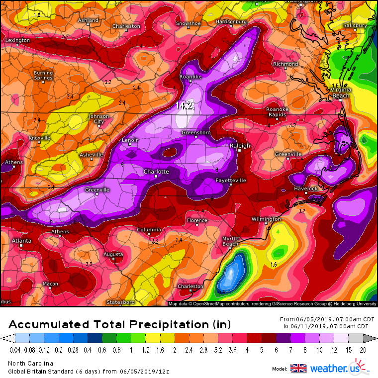
The Euro and Ukie both have something day 5 in the eastern gulf.The track is still in question but there could be some heavy rain especially on the eastern side of this crawling slowly north somewhere. Today's total on the Euro day 10
-
Looks like we'll get some fairly potent MCS action over the next 24 hours.The HRRR has the first arriving overnight with two more crossing Saturday afternoon. Damaging winds the big issue most likely,they are really flying moving SE.
-
Mid to Long Term Discussion 2019
NC_hailstorm replied to Upstate Tiger's topic in Southeastern States
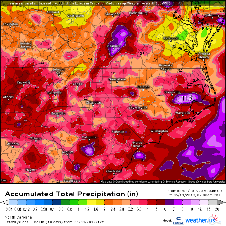
5 day totals on the Euro today.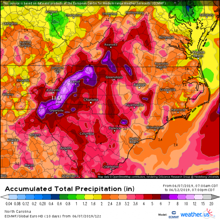
-
Mid to Long Term Discussion 2019
NC_hailstorm replied to Upstate Tiger's topic in Southeastern States
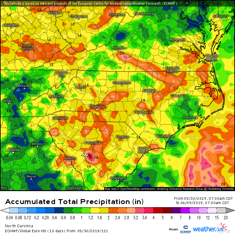
Ukie bringing it on today's run,6 day totals.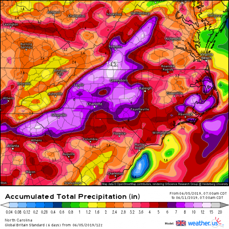
-
Mid to Long Term Discussion 2019
NC_hailstorm replied to Upstate Tiger's topic in Southeastern States
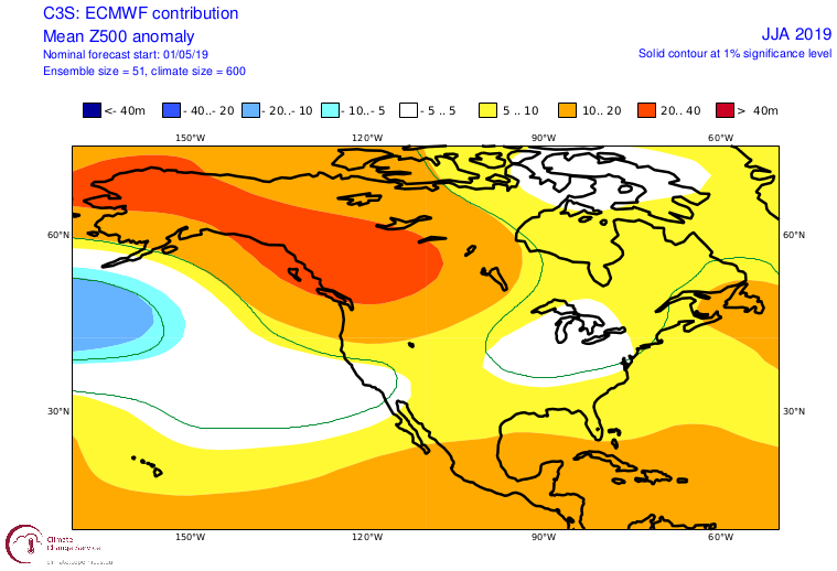
Seasonal forecasts on the Euro for the summer,2m temps and Heights for the next 3 months.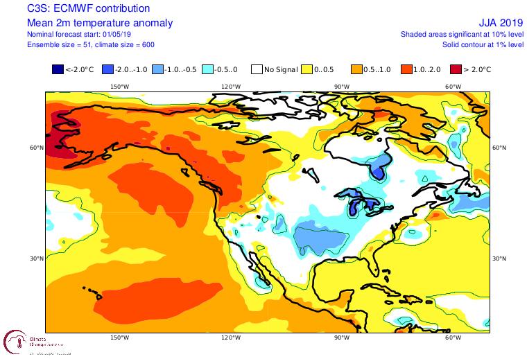
-
Mid to Long Term Discussion 2019
NC_hailstorm replied to Upstate Tiger's topic in Southeastern States
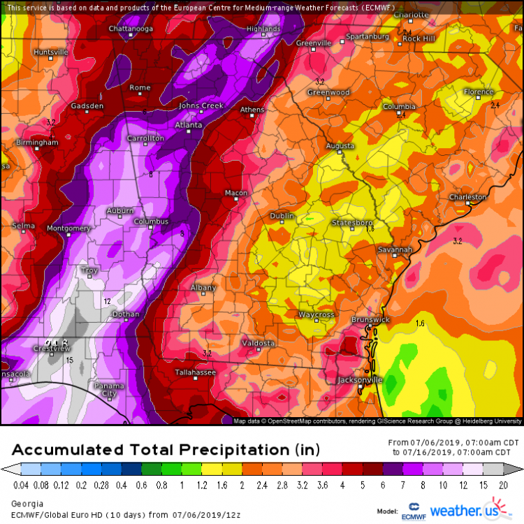
Euro continues to ramp up the precip,GFS similar.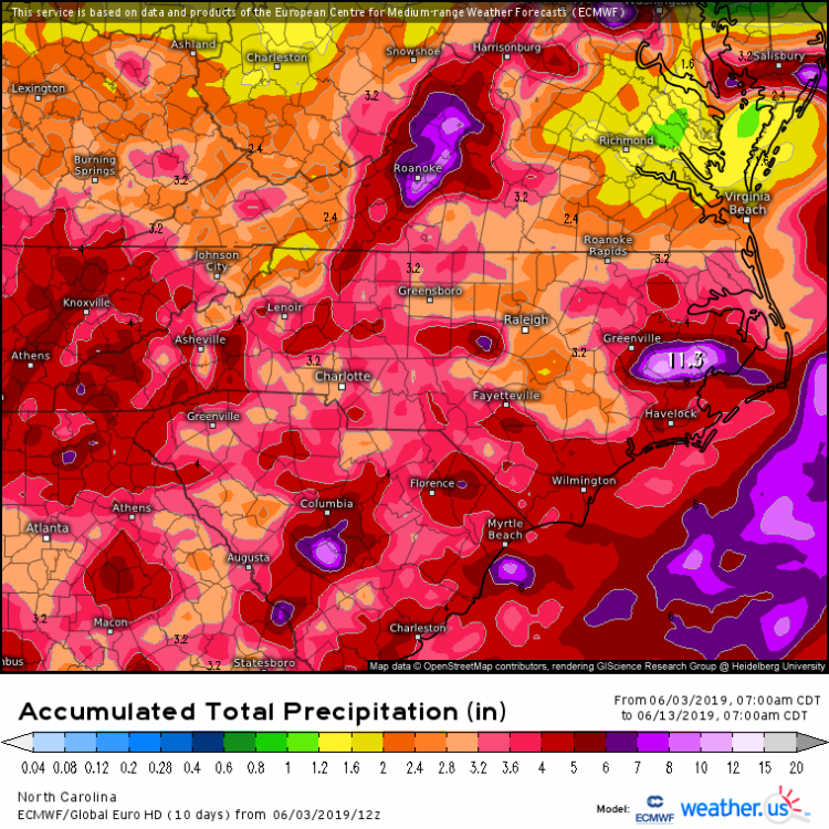
-
Mid to Long Term Discussion 2019
NC_hailstorm replied to Upstate Tiger's topic in Southeastern States
Lower heights/trof return tomorrow,death ridge being weakened and pushed back out.Better rain chances begin around day 6 on the Euro,GFS is similar.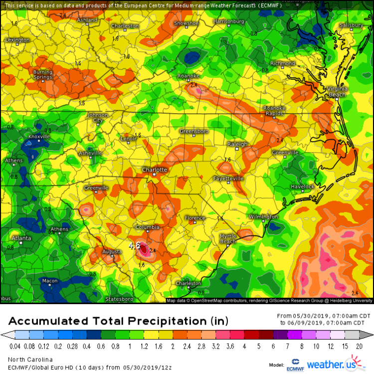
-
Mid to Long Term Discussion 2019
NC_hailstorm replied to Upstate Tiger's topic in Southeastern States
Pretty map today. -
Mid to Long Term Discussion 2019
NC_hailstorm replied to Upstate Tiger's topic in Southeastern States
Looks like this big cutter coming through this weekend will flip the pattern finally and put the low heights,PV on our side of the hemisphere. MJO has a good chance running out to 3/8 or 3/9 considering this sun rotation is coming much,much weaker than the previous one,first 10 days or so in March are in play IMO. -
Mid to Long Term Discussion 2019
NC_hailstorm replied to Upstate Tiger's topic in Southeastern States
All you want to do is hit the target somewhere more than half the time with all these models,model runs,ensembles,etc.You won't hit a bullseye with every run that's gonna come through here but enough hits keeps you in the hunt. Inside 48 hours is when you wanna start aiming for bullseyes. Just my opinion. -
Mid to Long Term Discussion 2019
NC_hailstorm replied to Upstate Tiger's topic in Southeastern States
Agree I'll take that look at day 6 on the Ukie.These heights usually bump north with time and the trajectory of them are more southwest-northeast at day 6 then day 5. -
Mid to Long Term Discussion 2019
NC_hailstorm replied to Upstate Tiger's topic in Southeastern States
Ukie has a 1011 low in far south Texas at day 6,pretty low heights across the southeast. -
Mid to Long Term Discussion 2019
NC_hailstorm replied to Upstate Tiger's topic in Southeastern States
Ukie has that piece of energy(1009 low)in Alberta at day 6,same thing the GFS and CMC show diving south/southeast to the gulf later on. Bout the only thing to watch at the moment. -
Mid to Long Term Discussion 2019
NC_hailstorm replied to Upstate Tiger's topic in Southeastern States
Ukie moved north from 0z and is more amped at 999 in S.central Alabama.Heights behind it and northeast of it are a bit lower though. That looks like a good hit for E.Tennessee and Ky if I had to guess,0z Euro had a 996 coming right through CLT at day 7. -
Mid to Long Term Discussion 2019
NC_hailstorm replied to Upstate Tiger's topic in Southeastern States
Should start to see some stronger high pressures coming down if the SSW was strong and persistent. They'll filter down from the strat to the troposphere,Ukie has a 1039 coming into SE Canada at day 6. -
Mid to Long Term Discussion 2019
NC_hailstorm replied to Upstate Tiger's topic in Southeastern States
Check out the heights crash on the Ukie. Has the 582dm line on the NC/SC border at day 2,then south of Cuba and approaching Jamaica at day 6.That line usually hangs around south/central Florida in a typical winter. -
Mid to Long Term Discussion 2019
NC_hailstorm replied to Upstate Tiger's topic in Southeastern States
The Euro and Ukie look close at day 6 with a decent trough/lower heights,that looks like phase 7-8 mjo signal starting to arrive. Euro has a follow up trough at day 8/9 with lower heights. Carry on with the moaning and complaining. -
Mid to Long Term Discussion 2019
NC_hailstorm replied to Upstate Tiger's topic in Southeastern States
Anyways at first glance on the Euro it looks like the strongest/coldest piece of the PV goes into Scandinavia at day 6.North America gets a smaller piece in Eastern Canada somewhere with decent blocking up over the top. First guess and subject to change on the SSW talk. -
Mid to Long Term Discussion 2019
NC_hailstorm replied to Upstate Tiger's topic in Southeastern States
Very poor scoring the last 5 or 6 days. -
Mid to Long Term Discussion 2019
NC_hailstorm replied to Upstate Tiger's topic in Southeastern States
All the models are scoring very poorly the last 5 days,anything 5 days and beyond should not be trusted at all until things shake out. -
Mid to Long Term Discussion 2019
NC_hailstorm replied to Upstate Tiger's topic in Southeastern States
Hit on the Euro today day 9/10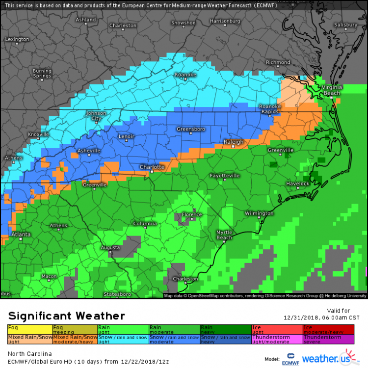
-
December 8-10, 2018 Winter Storm
NC_hailstorm replied to Orangeburgwx's topic in Southeastern States
Might wanna save this,850mb at 10 AM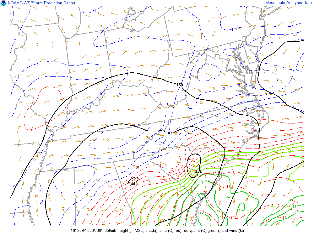
-
December 8-10, 2018 Winter Storm
NC_hailstorm replied to Orangeburgwx's topic in Southeastern States
Right now I'd say the Euro and the FV3 look pretty close with the cutoff line somewhere along highway 73 in the southern piedmont of NC. Sleet will probably mix in everywhere time to time with warm pockets coming through but more south of there. Carry on. -
December 8-10, 2018 Winter Storm
NC_hailstorm replied to Orangeburgwx's topic in Southeastern States
The FV3 has been running pretty well lately by the verification scores so we'll see. -
December 8-10, 2018 Winter Storm
NC_hailstorm replied to Orangeburgwx's topic in Southeastern States
Heights are a little lower on the Ukie with the 570dm deeper into the upstate and south of CLT this run compared to 42. It's only 20-25 miles maybe but every mile counts now.