ct_yankee
-
Posts
400 -
Joined
-
Last visited
Content Type
Profiles
Blogs
Forums
American Weather
Media Demo
Store
Gallery
Everything posted by ct_yankee
-
It's making my brain hurt trying to figure out which way that should be rotating.
-
Friday, May 15, 2020 Severe Weather Potential
ct_yankee replied to weatherwiz's topic in New England
Did they extend the watch and then trim it back again? I could have sworn I saw it covering almost all of CT a few minutes ago but now it only covers the northwestern corner. -
Friday, May 15, 2020 Severe Weather Potential
ct_yankee replied to weatherwiz's topic in New England
This is very underwhelming. I don't get the extended watch either. Good old New England, never disappoints, which is to say it almost always does. I always have zero expectation for these events, and once in a great while I'm pleasantly surprised. Not today, tho. So it goes. Edit: and we might have a spin up in VT as I post this. Yep, that figures. -
Friday, May 15, 2020 Severe Weather Potential
ct_yankee replied to weatherwiz's topic in New England
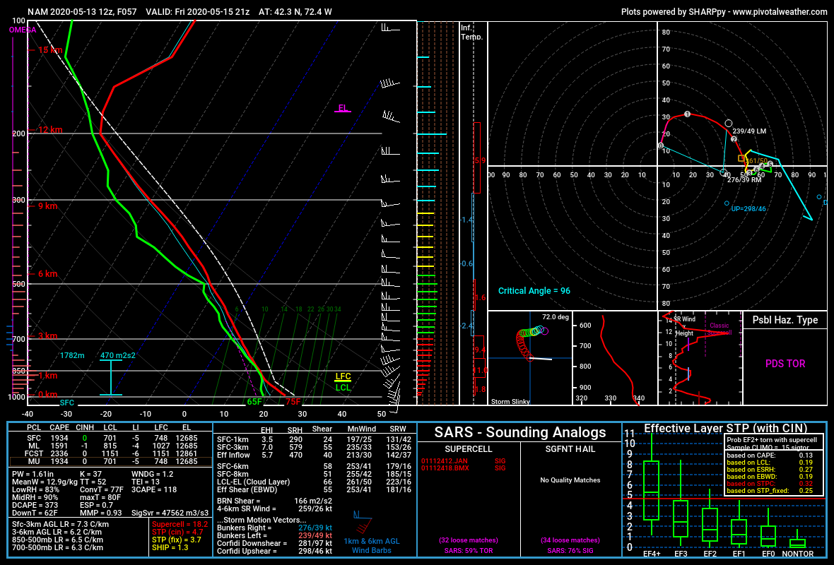
Nam sounding for central MA friday 21z:
-
I also wondered if there wasn't something screwy with radarscope so I looked elsewhere, specifically at SPC mesoanalysis, but there was no warning box there either. If there was a glitch I think it goes further than just radarscope.
-
Yeah, I was just driving home from Stony Creek about an hour ago and it seemed like we had at least a couple of inches already... The intensity of the snow has tapered since then, but it's still snowing and I agree the total's gonna be well over 2 inches... But does it really matter? Whether it's 2, or 4, or even 6, its all gonna get washed away by the rain, at least it will here in New Haven.
-
Near as I can tell by googling, it still requires a sign-in, it's marketed as "free with your TV provider". I don't see anything about free episodes without a sign-in, do you have a link that says different? Note: I do not want to sign up for any free trials that require giving up a credit card number in advance. Been burned before doing that.
-
Won't work for those of us who have either cut the cord or, like me, never had any cable or any other "TV provider". Would love to see Josh's show, but I get turned down with a message saying "your xfinity service does not include this program". I only use them for internet and mobile, which apparently isn't enough.
-
Oh FFS, President Sharpie didn't just say that there was a chance of Alabama getting hit, he specifically said they were going to be hit "harder than expected", something no weather map or model was indicating at the time, in fact the trend was exactly the opposite. After a presidential statement like that, BMX was absolutely correct in setting the record straight. And you know it.
-
So, does anybody still believe that the NWS/NOAA would never ever let politics dictate a weather statement, as was being professed on this board a few days ago? To be clear, I didn't think so then... But now? It's just f'n pathetic.
-
Fookin' A!!!
-
Wednesday, September 4, 2019 Convective Thread
ct_yankee replied to weatherwiz's topic in New England
You have all the tilts, but it's not immediately apparent from the labeling the app uses. It says Tilt 1 or whatever, but you only see the options to change to the other tilts when you try to change the radar product, you tap tilt one and then all four tilts will come up offering a choice. Not the best UI, it's true, but it suffices for 10 bucks. -
Wednesday, September 4, 2019 Convective Thread
ct_yankee replied to weatherwiz's topic in New England
Settings - > Radars and Locations -> locations -> add location Looks like, anyway, never tried it -
Wednesday, September 4, 2019 Convective Thread
ct_yankee replied to weatherwiz's topic in New England
Meh. Nice SLC type shelf, with very low hanging scud bombs, a few heavy drops of rain, some rumbles of thunder... Not the most memorable t-storm, for sure. -
Wednesday, September 4, 2019 Convective Thread
ct_yankee replied to weatherwiz's topic in New England
Very strong couplet for these parts. It could definitely produce. -
Wednesday, September 4, 2019 Convective Thread
ct_yankee replied to weatherwiz's topic in New England
Reverse psychology. Works even on mother nature. -
Wednesday, September 4, 2019 Convective Thread
ct_yankee replied to weatherwiz's topic in New England
The right split looks nice, but I think the hook stays offshore -
Wednesday, September 4, 2019 Convective Thread
ct_yankee replied to weatherwiz's topic in New England
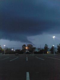
Looks like some decent mid-level rotation on the cell SW of Springfield. Hey, it's something. Yeah, I know... There, did it for you. -
Wednesday, September 4, 2019 Convective Thread
ct_yankee replied to weatherwiz's topic in New England
New MD out: SUMMARY...Threat for damaging wind gusts continues across much of Severe Thunderstorm Watch 634. DISCUSSION...Cold front continues to progress eastward across the Northeast and recent surface analysis places the boundary from north-central VT southwestward to just east of ALB to CXY (in southeast PA). Northern portion of the line of thunderstorms initially along the front has accelerated slightly ahead of it while also losing intensity. This loss of intensity is likely tied reduced lift away from the front and less buoyancy from lower surface temperatures. Warm layer noted around 500-600 mb on the 18Z ALB sounding could also be contributing to reduced updraft strength. Southern portion of this line of has maintained its intensity and is moving into a slightly more favorable thermodynamic environment. Expectation is for this portion of the line to continue eastward, posing a risk for damaging wind gusts. Additional development is also possible farther south along the front across far northeast PA and northern NJ. These storms will also pose a risk for damaging wind gusts. A low tornado threat remains, but surface winds have been veering westerly well ahead of the front, further reducing any tornado potential. ..Mosier.. 09/04/2019 That "pfffft" noise that you hear is the sound of our tornado chances evaporating... -
Wednesday, September 4, 2019 Convective Thread
ct_yankee replied to weatherwiz's topic in New England
SPC seems to believe there's a serious tornado threat, and it's hard to argue there isn't, especially wherever there's plenty of sunshine, like for instance here - always a good sign on a potential severe day... Think we'll finally see an actual tornado watch today? -
Some people appeared to be arguing it's real... But it's so hard to tell on here who's trolling and who's being serious...
-
Regarding that "satellite image", it is indeed sort of a fake. If you look closely you can see that the water is just basically photoshopped (figuratively speaking) into the image, the waves are not breaking where they should be, etc, etc. What they did is use a sat to figure out where the new water (new coastline?) currently is and then made an image that looks like a photo but actually isn't. It's an "artist's conception" kind of deal except the artist was probably a computer algorithm and the position of the water is probably spot on. It is NOT a satellite photograph! Ya gotta be careful these days about what's real and what isn't.
-
I've been thinking about the fact that there's been no sign of an ERC with Dorian. Everybody's been looking for that all day, but there's been nothing. Very weird. I'm thinking somewhere there's a painting of the hurricane, a picture, as it were... And if you look very closely and carefully at the picture of Dorian, there you will see the Eyewall Replacement Cycles. Only on the picture, while Dorian the storm sails on blissfully and forever unchanging. Well, it's a theory. I do like the name.
-
This was not 6/1/11, or anything like it. Still, we take what we can get.
-
That's like the 3rd time today in that same spot.