
ct_yankee
-
Posts
400 -
Joined
-
Last visited
Content Type
Profiles
Blogs
Forums
American Weather
Media Demo
Store
Gallery
Everything posted by ct_yankee
-
I actually wondered about that at the time, but was convinced by the fact that reflectivity started to show a cyclonic curving hook-ish look to the cell right after the couplet showed up. Admittedly that coulda just been coincidence, I suppose...
-
Spin up of some kind in Windsor looks like
-
Interesting you say that about tomorrow being the better day, last night I almost posted to that effect... But I'm just not confident enough in my forecasting abilities, especially on this board with so many truly knowledgeable people, so I never hit the submit button. But yeah as of late last night I thought Wed could be the better day, although storms probably won't be as widespread as today - but that can be a good thing from a chasing perspective. I'll see how today plays out, then take another look at tomorrow.
-
10 Year Anniversary. June 1 2011-2021. Monson Springfield MA
ct_yankee replied to HoarfrostHubb's topic in New England
Yeah this was one of the few times a NE event was well forecasted, IIRC SPC had a 10% tor in that region, and everything played out perfectly for once. Personally nailed the forecast too, I figured storms would initiate upstate NY moving from the hudson river/albany area towards Springfield, I remember trying hard to convince my friend who really isn't into this stuff to go up there, with an initial target just west of Springfield, definitely would have seen it. But his wife said something like "you're really going to drive all the way to MA just to look at some rain?" and he begged off. Should have gone alone, still bothers me that I didn't, but that's chasing in New England: you probably won't see anything, but you definitely won't if you don't go. Can't believe its been 10 years already. -
Beautiful supercell on radar ENE of Denver but must be nothing out that way, at least not in the way of cell service, since I can't find a single livestream that's active... Edit: Matt Grantham's stream is back on for that cell (heh, for a second)
-
Severe Weather April 23rd 2021
ct_yankee replied to weatherextreme's topic in Central/Western States
What a beautiful storm! Has produced at least 3 photogenic cones so far and some dusty spinups, streaming has been intermittent so total could be higher than that. Impressive stuff! -
Southern CT def gettin smoked. Seems like most of our major snowstorms these last few years have tended to deliver the majority of the snow in quick bursts of extreme accumulation, like that Dec. storm where we picked up the better part of a foot mostly in just a couple hours... But this one, this has just been solid very heavy snow/near blizzard from the moment I woke up today (which admittedly was close to noon) and it's still going strong as ever right now, with no letup. That is indeed impressive, and its definitely been a minute since we've seen one like this.
-
Active mid December with multiple event potential
ct_yankee replied to Typhoon Tip's topic in New England
As they do... -
Getting the goods now in downtown New Haven for sure. Too windy to say how many inches might be on the ground, but there's a certified crap-ton in the air...
-
Seems to be regenerating its CDO at a healthy pace, it certainly looks like its strengthening. I suspect if this same exact storm were in this same exact place but being born for the first time there would be quite a bit of interest, at the very least some wild wishcasting posts. Instead, the board seems to be burnt out on ETA. I suspect a lot of people just wish it would go away at this point. I admit that right now it doesn't seem to have a very bright future, but still...
-
Wednesday, October 7, 2020 Convective Potential
ct_yankee replied to weatherwiz's topic in New England
According to this paper: https://www.spc.noaa.gov/publications/corfidi/ldd_2006.pdf it's below 50 and/or pwat<.5: "More rarely, high-wind-producing MCSs occur in en-vironments of very limited moisture, with surface dew-points at or below 50°F (10°C) and/or precipitable wa-ter less than 0.5 in. (1.25 cm). Systems forming in suchenvironments, herein referred to as low-dewpoint dere-chos (LDDs), have been observed throughout much ofthe year and over much of the United States from theGreat Basin to the East Coast. " Personally I would guess that this event might be classified as a hybrid serial/low-dewpoint derecho. If that is a thing. -
Wednesday, October 7, 2020 Convective Potential
ct_yankee replied to weatherwiz's topic in New England
Apparently not. Two MDs were issued with watch probabilities at 20% and 40% respectively, but even after the event was well underway they apparently didn't pull the trigger on a watch. Pretty unbelievable in retrospect, looking at the storm reports. -
Wednesday, October 7, 2020 Convective Potential
ct_yankee replied to weatherwiz's topic in New England
Holy F**K that was some insane gusts from this, whole building was shaking... Edit: was not expecting that at all, not from that weak looking part of the line, miles from where it looked to be severe. Impressive event. -
Significant Severe Weather Event Possible Thursday, August 27, 2020
ct_yankee replied to weatherwiz's topic in New England
I do not agree that the EH high school video shows the tornado, looks like straight line stuff to me. At no time does the wind direction change. Extremely powerful, nonetheless. The high end downbursts were clearly just as damaging if not more so than the tornado. -
Significant Severe Weather Event Possible Thursday, August 27, 2020
ct_yankee replied to weatherwiz's topic in New England
So in the end this turned out to have been modeled rather well, at least by the CAMs. Warm front placement pretty much as advertised, supercells along front as advertised, and all the damage seems to have occurred along that line (at least in CT), mostly from that one storm. I feel for those who lost power and property tho, never want to see that... -
Significant Severe Weather Event Possible Thursday, August 27, 2020
ct_yankee replied to weatherwiz's topic in New England
Just spoke to a friend in Stony Creek area of branford. He couldn't get to his home on rt146, had to park way up by the highway and walk... Naturally no power when he finally got there. Sounds like a real mess, and yeah they only just recovered from the TC, probably looking at another week without power... -
Significant Severe Weather Event Possible Thursday, August 27, 2020
ct_yankee replied to weatherwiz's topic in New England
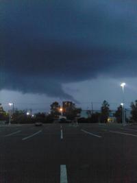
Crazy storm, when it went over New Haven it was moving so fast I literally didn't have time to hold the phone up for a shot of the meso. Between when the tor warning went out and when it hit was literally a few minutes. I got one good look at the meso/wall cloud and then wham, crazy sideways rain and visibility = 0. Would not be surprised if there was a tor in there near North Haven, it really ramped up then. Was all over in like 10 minutes, with sunshine on the other side. Crazy. Really wish I had got a pic tho, was very cool looking, if only for a few secs... -
Significant Severe Weather Event Possible Thursday, August 27, 2020
ct_yankee replied to weatherwiz's topic in New England
The areal coverage may be too small for a mod risk. Finally had a chance to look at the models after spending way too much time in the tropical forums. As has been mentioned this looks to be very tightly focused on the warm front in the afternoon, which most of the CAMs are placing approx. on a line running NW/SE from just S of Albany to near New London, give or take 30 miles depending on the model. There will likely be a supercell somewhere in this area, beyond that its not so clear cut. A small mod risk is remotely possible if the models come further into agreement on placement of the front I suppose. I agree the numbers are very nice looking right now, but that's really only over a relatively small area. -
Significant Severe Weather Event Possible Thursday, August 27, 2020
ct_yankee replied to weatherwiz's topic in New England
About East Rock, they used to close the park whenever severe weather was incoming, I got kicked off the top by park rangers a couple times. The fact that it's closed may actually be an advantage in that regard. But it's a helluva walk from the base parking lot, unless you're in much better shape than me (likely, now that I think about it). Its the best vantage point in the area for sure, only disadvantage is that if at the last moment you decide to go for a target elsewhere you're stuck in the middle of urban traffic, usually right at rush hour. -
The tornado threat tomorrow in SNE is legit. Usually with TCs we're starved for instability but most of these systems come through in the fall, I can't really remember the last time we had one right at the peak of high summer when the atmosphere is already juiced. Could definitely get interesting.
-
Sunday, August 2, 2020 Convective/Severe Potential
ct_yankee replied to weatherwiz's topic in New England
Man, I thought the day was ruined after that first wave of crapvection but the atmosphere recovered enough for the one small storm to get it done - at least twice, and maybe more than that. Now imagine what it would have been like with a little more forcing and/or an EML. Excellent pics and video, very cool stuff. -
Wednesday, July 22, 2020 and/or Thursday, July 23, 2020 Severe Threat
ct_yankee replied to weatherwiz's topic in New England
Nice! Some pretty decent structure there... -
Wednesday, July 22, 2020 and/or Thursday, July 23, 2020 Severe Threat
ct_yankee replied to weatherwiz's topic in New England
That stuff that blew up to my southwest is headed this way... Haven't actually managed to get in a severe storm all summer, maybe this will do it... Nah, it's coastal CT. -
Wednesday, July 22, 2020 and/or Thursday, July 23, 2020 Severe Threat
ct_yankee replied to weatherwiz's topic in New England
Sweet little supercell in MA, at least for a few scans. The MA cells are interacting with warm front/boundary, and also each other... Many splits but some definite spin in places. Too bad it looks like it will all congeal. Still, I don't think you could call this a bust. -
Saturday, June 27 - Sunday, June 28, 2020 Convective Thread
ct_yankee replied to weatherwiz's topic in New England
Slight risk extended into parts of CT... I think they did it just for you, Wiz.

