

RogueWaves
-
Posts
2,559 -
Joined
-
Last visited
Content Type
Profiles
Blogs
Forums
American Weather
Media Demo
Store
Gallery
Everything posted by RogueWaves
-
Big dump on NMI 11/5/90 also melted off just in time for a brown opener.
-

Winter 2023-24 Longrange Discussion
RogueWaves replied to michsnowfreak's topic in Lakes/Ohio Valley
Let's just do this!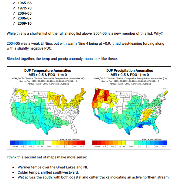
-
Winter 2023-24 Longrange Discussion
RogueWaves replied to michsnowfreak's topic in Lakes/Ohio Valley
As @michsnowfreak posted, it wasn't a complete whiff for Detroit. Even the city reported 5" depth, and Pontiac was 10". But it was one of those shoulder season systems just cold enough to snow, and a week later only piles remained. Jackson and the Tri-Cities regions were both epicenters and no doubt memorable similar to my own April '75 Big Dog experience.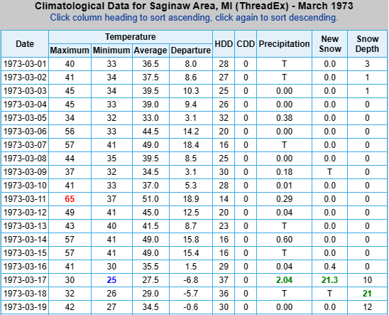
-
Fall 2023 Medium/Long Range Discussion
RogueWaves replied to Chicago Storm's topic in Lakes/Ohio Valley
None too soon for the h300 fantasy snow maps. Thanksgivings in the early 00's featured several cold and or snowy ones iirc. Vividly recall 2005 when my fam met in Frankenmuth for a holiday dinner and it was like 5F WC's. -
Fall 2023 Medium/Long Range Discussion
RogueWaves replied to Chicago Storm's topic in Lakes/Ohio Valley
Some day, peeps will be posting about "the ghost of JB". Like him or not, that's a legacy hard to deny. -
I'm there. My recent string of bad winters has been brutal in this regard. Ofc, my preference is not just a few inches OTG, but substantial amounts. The quick to come, quick to go EC scenario might be fun when it happens but getting basically nada in between (over multiple seasons even) would be downright awful.
-
And gun deer opener in NMI was a sunny and balmy affair. Felt more like October's bow season (which hadn't been born yet). 75-76 went on to be the first in a string of historic winters for both cold and snow in the Lower Lakes region. Especially known as a banner LES winter. But even places like my home region (KFNT) had their (then) snowiest January for instance. Only beat since by 2014. To note, that warm November of '75 did feature a cold bout around Thanksgiving and featured some snow systems that ended up making it a very snowy month in the end. A month of extreme contrasts, at least in my home region.
-
Winter 2023-24 Longrange Discussion
RogueWaves replied to michsnowfreak's topic in Lakes/Ohio Valley
Not sure which season you are speaking of there? As for the wild swings, see my other post and I agree. 1991-92 may fall into that camp as well. Iirc, it was a Nino that delivered an impressive "Detroit Special" in mid-January (some say it was a triple-phaser). 10-15" across the region in very dynamic fashion had much of the city at a virtual standstill. I was living in Traverse at the time and we'd had a blah season to that point so I wasn't too happy, lol. -
Winter 2023-24 Longrange Discussion
RogueWaves replied to michsnowfreak's topic in Lakes/Ohio Valley
09-10 was actually an AN snowfall season further west. Then we slid downwards as 2010-11 favored SEMI better than SWMI. You'd see that if it weren't for all the "M's". I really like how there's an "M" for the season in 19-20 even tho none in the months for that year: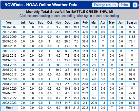
-
Winter 2023-24 Longrange Discussion
RogueWaves replied to michsnowfreak's topic in Lakes/Ohio Valley
That's why I said we'd need a colder version like the Mod Nino of 02-03. Despite this early warmth (which I'm fine with tbh), I think we have a shot at the colder scenario working out. We may get there via some crazy swings though. Torch months like Dec '14 mixed with record cold months like Feb '15 could be in play. I doubt it gets cold and stays that way like 02-03. Palm peeps say that's in the mirror now for our region anyways. -
Top notch shed
-
Winter 2023-24 Longrange Discussion
RogueWaves replied to michsnowfreak's topic in Lakes/Ohio Valley
It was known for the St. Patty's Day storm that buried cities like Jackson and Bay City with 20+. A colder version is what SEMI needs. Something between 72-73 & 02-03 -
Yes. An article cited a storm that had a 120 mph wind increase in 24 hrs.
-
Move off the beach
-
31F this morning, monkey off back, rolling on the ground kicking and screaming
-
@michsnowfreak Great photos as always! I have a few nice color shots that look great on my phone (yeah cell phone cam - I know), but look like dull crap when I post them. Wish I knew why?
-
Winter 2023-24 Longrange Discussion
RogueWaves replied to michsnowfreak's topic in Lakes/Ohio Valley
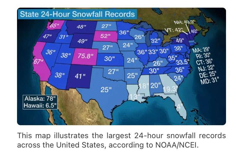
Cuz bored waiting for more active wx I guess. Doesn't impact yby, KTOL unchanged anyway. Couldn't help but notice IN and it's mismatch across state line with OH. As for MI changing, now IWX will be issuing warnings that will dead-end at the MI state line (at least in theory & knowing GRR). And how do the LES counties of NWIN not get the same treatment as in MI? For that matter, could be said of IL & WI as well. Guessing the only way IL & IN beat MI on its state record 24 hr snowfall was due to some obscure LES events lost to time (SMH).
-
Summer flowers including Petunias were going strong here on the edge of the UHI in NW Wayne Cnty. I'm sure once you get N or W of here that changes quickly as you have seen up in Fenton area. DTW hit 38F and I'm hoping clouds can cooperate for a solid 32F Monday morning to get that monkey off our back.
-
I've seen the ground totally white under sugar maples in full red (Oct 2013). This year it's full colors blazing while summer flowers are still untouched by any true cold. Colors today across SMI are stunning despite no really frosty mornings yet. Vibrant colors were expected since we had a moist summer here.
-
Winter 2023-24 Longrange Discussion
RogueWaves replied to michsnowfreak's topic in Lakes/Ohio Valley
Conversely, he could be forecasted 12+ and not even reach 6.9". If only the headlines meant a guaranteed total, lol -
Winter 2023-24 Longrange Discussion
RogueWaves replied to michsnowfreak's topic in Lakes/Ohio Valley
Yes, strangely it had slightly AN plowable events and managed to reach within 3% of a normal seasonal total. But snow cover was a negative number, and Christmas at 57F and the entire holiday week 50s-60F blew chunks. I'd call it the mildest winter of my life that still managed avg snow, lol. If I did what many here do (try to grade a winter) I would have to admit that snow cover/retention is heavily weighted in my scoring and extended deep snow pack even more my thing would bump a grade. -
Winter 2023-24 Longrange Discussion
RogueWaves replied to michsnowfreak's topic in Lakes/Ohio Valley
Translation - it sucked. -
Winter 2023-24 Longrange Discussion
RogueWaves replied to michsnowfreak's topic in Lakes/Ohio Valley
Good outbreaks of CAW seem to last only about 6 wks max. It is the rare events like the Jan '85 flip that may exceed that. Less than 6 wks ofc happens way more often. -
2023 Short/Medium Range Severe Weather Discussion
RogueWaves replied to Chicago Storm's topic in Lakes/Ohio Valley
Best vid I've seen on The Mitt's darkest day of severe wx: -
Does anyone know how much ash that large eruption in the Pacific generated?

