

Hitman
-
Posts
2,856 -
Joined
-
Last visited
Content Type
Profiles
Blogs
Forums
American Weather
Media Demo
Store
Gallery
Everything posted by Hitman
-
Nothing here as of yet. 24f. Winds ese. Gonna take the train into the city shortly.
-
Totally unscientific but it seems to me, these pattern changes always take longer to come about than projected. I’m not getting my hopes up just yet.
-
color me skeptical, but that's my nature. what a freaking boring weather period.
-
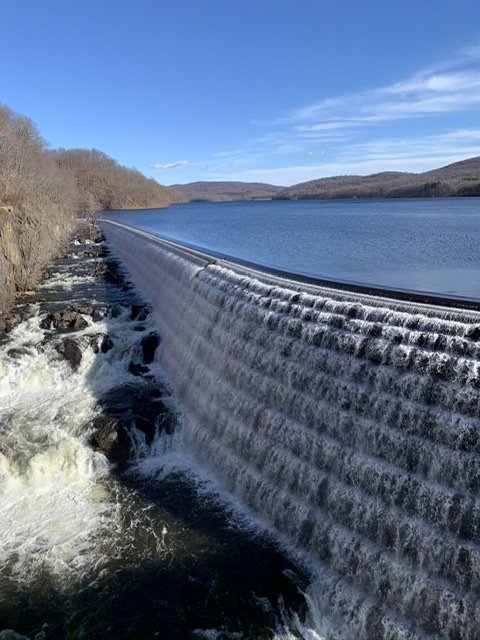
Turned out beautiful. Croton reservoir is full again.
-
January 2020 General Discussions & Observations Thread
Hitman replied to Rtd208's topic in New York City Metro
May have been here. I got .25”. -
.25” in the bucket and 60f, 60dp. Lovely day for ....I don’t know what.
-
It was weird out. Felt good to get a ride in though.
-
Biking in shorts.
-
Pia to get to but if you’re into snow, prefer it dry and don’t need to stay on the mountain, it’s great. If u need any info, pm me. This will be my 6th trip to Nelson.
-
I’m going to whitewater in a month. They have a settled snowpack of 95”.
-
Sb reporting 4”. Nice squall.
-
I got back last night from 10 days up in the MRV. Good reminder of what winter is supposed to be like.
-
Snowed all morning on the hill. Pretty windy early on. Everything was blown off the trails. Woods were good.
-
Yeah, I don’t know. They reported 4” at 4pm and the cams both have 4”. I’m eyeballing 3” down in the valley. We’ll see tomorrow morning.
-
Wow, these are the biggest snowflakes I’ve ever seen. Monster parachutes.
-
First flakes just started. 32f in the valley.
-
Was pretty close to epic yesterday. Fresh snow everywhere. Woods were totally in play.
-
Interesting day. At Lincoln peak there was a nasty ice crust the top 250’ from the summit. Nothing below that. All sand otherwise which was dense.
-
Back to light snow.
-
29f and icing. Looks like about an inch down.
-
All snow here now. Medium size flakes.
-
Started here around 9. All frozen so far. Basically ice. Solid coating on everything. 32f. Down in the valley in Warren.
-
Yeah, I don’t want to get ahead of myself or anything, but I could use a little luck to shine upon us this week. I just got my first 2 days on the boards yesterday and today. Needless to say, conditions were suboptimal. But I put in my time so I figure come Tuesday Wednesday things should turn.
-
Happy holidays! finally back in the north country. This sounds promising. .LONG TERM /TUESDAY THROUGH FRIDAY/... As of 404 AM EST Saturday...As the aforementioned upper low traverses the region during the Tuesday/Wednesday timeframe, active weather will persist across the North Country, but confidence is much higher by this point in the storm that the ptype will be all snow in the higher terrain, and a mix of rain and snow in the valleys. Fairly widespread precipitation will continue through the day Tuesday with some light accumulations possible before the flow turns to the west- northwest and precipitation becomes more terrain focused. Some good indications that conditions become favorable for a period of upslope snow Tuesday night through Wednesday with a closed 700mb circulation northeast of the forecast area, which could result in some nice higher elevations snows.
-
Wall to wall winter just ain’t happening so may as well deal with it. Still some random ice around and on the lakes. happy holidays.


