usedtobe
-
Posts
8,812 -
Joined
-
Last visited
Content Type
Profiles
Blogs
Forums
American Weather
Media Demo
Store
Gallery
Everything posted by usedtobe
-
Personally, in these really marginal temp event, I use the snow depth product. It's more conservative with amounts which is a good think. If it's really cold other snow maps are probably preferable. The GFS snowdepth product from the 18Z run.
-

Jan Medium/Long Range Disco: Winter is coming
usedtobe replied to stormtracker's topic in Mid Atlantic
Interesting that 1964-1969 was a snowy period. -
I think your last two sentences are correct. We need the heavier precipitation and associated vertical motion to keep temps cold enough for snow. Of course not for me.
-
3.13" 2 miles north of Dunkirk in Calvert County.
- 240 replies
-
- 12
-

-
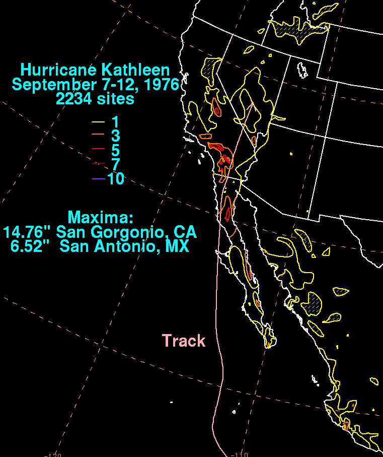
Kathleen in 1976 had almost an identical track. It cause lots of flooding and pretty much wiped out one town.

- 427 replies
-
- 11
-
-

-
I think that pretty much what the 06Z GFS was forecasting. The GFS definitely has problems. It's been running hot or at least that has been my perception. Still 96 or 97 with dewpoints in the 70s is nasty.
-
March Medium/Long Range Thread: The Empire Strikes Back
usedtobe replied to stormtracker's topic in Mid Atlantic
-
Late February will be rocking. February Long range Discussion thread
usedtobe replied to Ji's topic in Mid Atlantic
Looks bad. -
Getting my minutes of snow.
-
It's what you'd expect with most fronts east of the mountains.
-
Another 1.84" for the event. Managed to walk 4 miles in the morning before the rains came.
-
No thunder, ended up with 0.23"
-
I power washed my boat yesterday. The warm temps really motivated me to do something I hadn't done for a couple of year. The other motivation was the boat had lots of bird poop on it from being parked in its slip in Florida and really needed a wash. Anyway, boat carpet looks the best it's looked in years. I still need to fill the various boating compartment that I emptied prior to the wash. I'm looking forward to fishing this spring if gas prices don't limit me too much. I rarely post here anymore because I do the Capital Weather Gang bit but still stop by and read thoughts on storms and remember how much I enjoyed interacting with everyone. I am hoping to see a few snowflakes though it's doubtful I'll see accumulations.
- 364 replies
-
- 12
-
-
The 12Z 3km Nam is warmer than the 06Z. Has a deep isothermal layer with temps above freezing by a degree or two for about 6000 or 7000 feet. I just want 050" of rain as my plants need it.
-
Feb 24-25, 2022 Ice/Sleet/Rain/Snow (yeah sure) Storm Thread
usedtobe replied to WinterWxLuvr's topic in Mid Atlantic
39 degrees at 9:00AM in northern Calvert County. I'll happily keep my light non frozen wimpy rain. -
Feb 24-25, 2022 Ice/Sleet/Rain/Snow (yeah sure) Storm Thread
usedtobe replied to WinterWxLuvr's topic in Mid Atlantic
The temp and dewpoint at 830 mb looks a tad warm for refreezing so it will be interesting to see if you get sleet or not. -
Feb 12/13 Event Quest for Blues to Envelop More Rather Than Less
usedtobe replied to North Balti Zen's topic in Mid Atlantic
Beware, of the 10-1 ratio snow plots, The GFS has DCA with over 4" but the GFS never gets the 2m temp below freezing. In this case the pivotwx snow depth product is likely to be better. Of course, the models haven't yet converged on where the heaviest precip band will be located. -
Yep and the UKMET and GFS are in one camp and the Euro and Gem are in the other.
-
1) PD1 1979, thee highest hourly snowfall rates I"ve ever seen. Also, a colleague at work told me the storm was over after the 1st 4" and that we might see another inch with the vort. 2) Feb 5-6 2010, my second biggest snowstorm in terms of accumulations. 3) March 1958. Much like this storm this year, I had 16" of heavy wet snow that knocked out our power for a week. We cooked over the fire in the fireplace like cowboys. I thought that was neat. My dad and mom weren't as thrilled since they had to keep bailing the basement to keep water from reaching the freezer. 4) the blizzard or 1966. Snow drifts reached the second story of my high school. Wind driven snow in with temps below freezing and the only true ground blizzard for a couple of hours after the snow ended. 5) December 2009 storm. The most snow in December i can ever remember from a storm. 6) honorable mention: the 1993 storm of the century because I got to do a live interview on the Today show. My snow turned to rain but then we had a flash freeze and my remaining snow became on huge ice block.
- 293 replies
-
- 12
-
-
January 28-29 2022 Miller abcdefu Storm Obs/Discussion
usedtobe replied to mappy's topic in Mid Atlantic
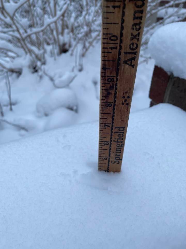
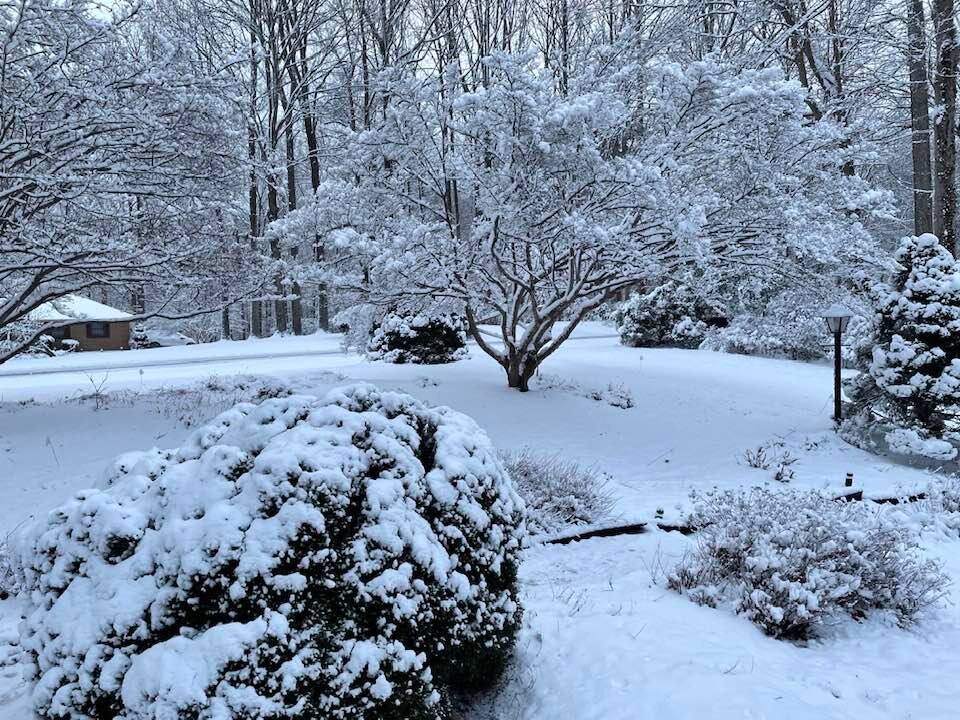
My snow today, 4 inches on my brick wall at the back of our driveway. Very pretty!
-
This system always has had a tough road to travel. The upper trough is too round and the low is too strung out to so it was always hard to believe the 18Z NAM and the earlier GFS models. Still there was enough uncertainty to not completely gainsay it. I'll be satisfied with mood flakes like the 00Z model has.
- 359 replies
-
- 14
-
-
0.52 yesterday. I was in a severe thunderstorm warning but didn't have much wind.
-
0.19" here in northern Calvert. That will teach me not to give the hurricane model radar forecasts much credence at our latitude.
-
The HRRR gives me nada as the Virginia convection lifts north and the convection closer to the storm stays east. The high res models are certainly different. the 12z HIRES nam misses me to the south and east. I guess radar will let us know which model grouping is correct. I don't have much of a feel for the system as I don't trust the HRRR. I do find the hires NAM discouraging however.
-
It will be interesting to see what the euro does. On average, I think it has generally been west of the GFS with the storm. Not sure whether that's a bias or it being better as I can't remember what it did last summer with tropical systems.