
Kay
-
Posts
1,900 -
Joined
Content Type
Profiles
Blogs
Forums
American Weather
Media Demo
Store
Gallery
Everything posted by Kay
-
17
-
Yeah that 1/6 report is
-
Low of 19. Got up to 26, temp ticking down now, 25
-
I've noticed that, too. I know there are ridges up around that area but still.
-
Mm marshmallows... always enjoy the pics from your place. Finished with 1.25" here. Nice to have some snow cover for the cold.
-
Snowing nicely here in the SE Harford lowlands. Just measured 1"
-
15 minutes later light snow, coating, even street caved 33
-
Finally some precip to speak of. Light snow...wet snow, maybe some sleet. 34
-
The obs thread: a Land of Contrasts
-
didn't see this posted so what the heck... Special Weather Statement National Weather Service Baltimore MD/Washington DC 112 PM EST Sun Jan 19 2025 DCZ001-MDZ008-011-013-014-504-506-508-VAZ025-026-029-038>040-051- 053-054-501-502-504-506-508-526-527-192300- District of Columbia-Cecil-Southern Baltimore-Prince Georges- Anne Arundel-Central and Southeast Montgomery- Central and Southeast Howard-Southeast Harford-Augusta-Rockingham- Page-Greene-Madison-Rappahannock-Culpeper-Fairfax- Arlington/Falls Church/Alexandria-Northern Fauquier- Southern Fauquier-Eastern Highland-Eastern Loudoun- Central Virginia Blue Ridge-Northwest Prince William- Central and Southeast Prince William/Manassas/Manassas Park- Including the cities of Washington, Elkton, Baltimore, Bowie, Suitland-Silver Hill, Clinton, College Park, Greenbelt, Laurel, Camp Springs, Glen Burnie, Annapolis, Severn, South Gate, Severna Park, Arnold, Odenton, Bethesda, Rockville, Gaithersburg, Silver Spring, Columbia, Ellicott City, Aberdeen, Staunton, Waynesboro, Stuarts Draft, Harrisonburg, Luray, Shenandoah, Stanley, Stanardsville, Madison, Culpeper, Reston, Herndon, Annandale, Centreville, Chantilly, McLean, Franconia, Arlington, Alexandria, Falls Church, Warrenton, Turnbull, Monterey, Leesburg, Ashburn, Sterling, Wintergreen, Haymarket, Dale City, Manassas, Woodbridge, Lake Ridge, and Montclair 112 PM EST Sun Jan 19 2025 ...PERIOD OF MODERATE TO HEAVY SNOW THIS AFTERNOON... A mix of light rain, sleet, and snow will transition to a period of moderate to heavy snow this afternoon from west to east through 3 PM. Snowfall rates of around or a little over one inch per hour are possible during the mid afternoon hours, along with reductions in visibility to one-half mile or less and temperatures falling below freezing. Snow will wind down from west to east between 5 and 8 PM, but temperatures will continue to fall through the 20s. A quick accumulation of snow is expected this afternoon, which will impact travel. After the snow, any lingering moisture will freeze given the falling temperatures.
-
Down to 35. Still pretty dry.
-
"Colder temps/bands of heavier precip are expected to press E/SE through the day, eventually reaching the metros by 2-3PM."
-
39/33 here, almost no precip so far
-
Great shot! Looks like the eagles may have just enjoyed some lunch. Always amazed how tough waterfowl are in the winter. I know they're built for it but still. Just casually swimming around in ice water.
-
URGENT - WINTER WEATHER MESSAGE National Weather Service Baltimore MD/Washington DC 1246 PM EST Sat Jan 18 2025 MDZ008-011-504-506-508-VAZ025-038-039-504-508-190200- /O.NEW.KLWX.WW.Y.0005.250119T1200Z-250120T0000Z/ Cecil-Southern Baltimore-Central and Southeast Montgomery-Central and Southeast Howard-Southeast Harford-Augusta-Greene-Madison- Eastern Highland-Central Virginia Blue Ridge- 1246 PM EST Sat Jan 18 2025 ...WINTER WEATHER ADVISORY IN EFFECT FROM 7 AM TO 7 PM EST SUNDAY... * WHAT...Snow expected. Total snow accumulations between 2 and 4 inches. * WHERE...Portions of central, northeast, and northern Maryland and central, northwest, and western Virginia. * WHEN...From 7 AM to 7 PM EST Sunday. * IMPACTS...Travel could be very difficult. The hazardous conditions will impact travel. * ADDITIONAL DETAILS...Snow will overspread the area Sunday morning and continue through the afternoon before tapering off during the evening. Snowfall rates could approach 1 inch an hour at times. Temperatures will fall into the teens Sunday night so any lingering moisture on area roadways will freeze.
-
Annual tradition of imagining @stormtracker play by play delivered in Dr. King's voice eta - well posts, bc I guess annual is a stretch for pbp being needed don't come at me stats weenies
-
1/16 - 0.25" which is an estimate. I had too much going on to measure but had a coating in the afternoon then another more substantial coating in the eve, had to clear the car
-
Only amounted to a dusting here...but nice to see snow falling for several hours.
-
This. Hours of light snow/intermittent flizzards.
-
Flurries
-
Low of 15.
-
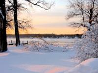
sunset alert
-
12/24 - T 1/3 - T 1/6 - 4.75" 1/11 - 1.25" Total - 6"
-
Relatable. 18z GFS - take and run.
-
My post above (in response to a...what are north crew thoughts/stages of grief lol) worked out pretty well in the end. Finished with 4.75", slightly higher than other sparse reports, but not inflated, one decent evening band was a help. Going to enjoy the snowcover and hope for a refresher


