
.jpeg.88e30b1573920286ceacf89f239564d2.jpeg)
wolfie09
-
Posts
17,315 -
Joined
-
Last visited
Content Type
Profiles
Blogs
Forums
American Weather
Media Demo
Store
Gallery
Everything posted by wolfie09
-
.thumb.jpeg.b9e232a6b43e01b7eeee3144246db864.jpeg)
Upstate/Eastern New York
wolfie09 replied to BuffaloWeather's topic in Upstate New York/Pennsylvania
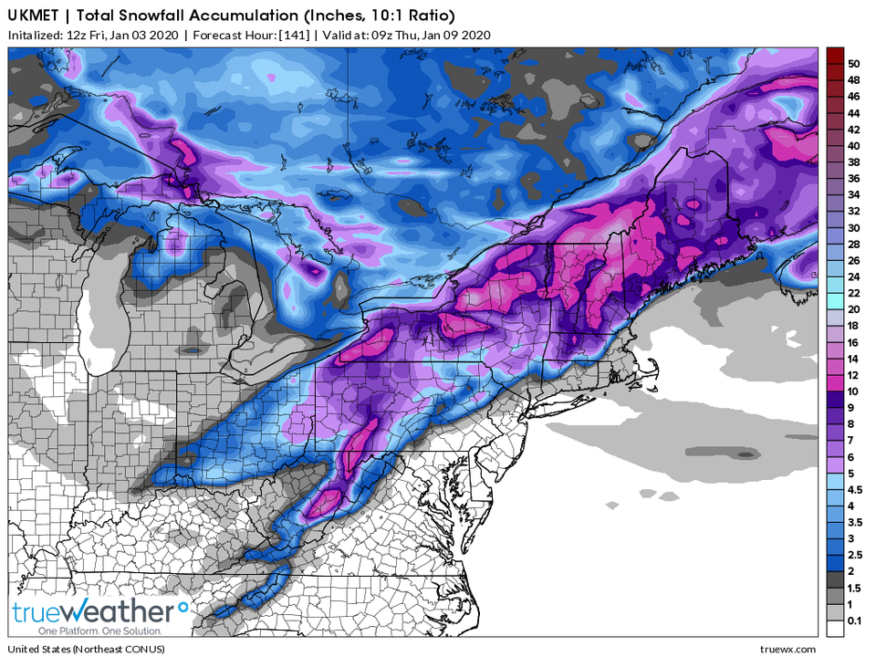
Euro with a big snowstorm day 9 as well.. Another system up the OV that transfers lol -
Upstate/Eastern New York
wolfie09 replied to BuffaloWeather's topic in Upstate New York/Pennsylvania
-
Upstate/Eastern New York
wolfie09 replied to BuffaloWeather's topic in Upstate New York/Pennsylvania
NE is always the best place to be with these type of systems.. Even a late capture can deliver decent snow if it heads for the gulf of Maine...thumb.png.5178bd8ae7ac2c22a2bc8e870914b937.png)
-
Upstate/Eastern New York
wolfie09 replied to BuffaloWeather's topic in Upstate New York/Pennsylvania
Euro late to the party as well.. Similar to the Canadian and ukmet...thumb.png.cbe878571bbecba2fff752e2b8199933.png)
.thumb.png.67f74f18dc136a7ffe4e7a9275c4f858.png)
-
Upstate/Eastern New York
wolfie09 replied to BuffaloWeather's topic in Upstate New York/Pennsylvania
So the global models and rgem have mostly rain/mix while the NAM/Hrw products, hrdps and hrrr have mostly snow, not that it would amount to much...thumb.png.7fd5011c33171ede312dfc41a366dd5a.png)
-
Upstate/Eastern New York
wolfie09 replied to BuffaloWeather's topic in Upstate New York/Pennsylvania
U can start seeing grass showing.. But it still looks somewhat like winter lol Doesn't feel like it though.. -
Upstate/Eastern New York
wolfie09 replied to BuffaloWeather's topic in Upstate New York/Pennsylvania
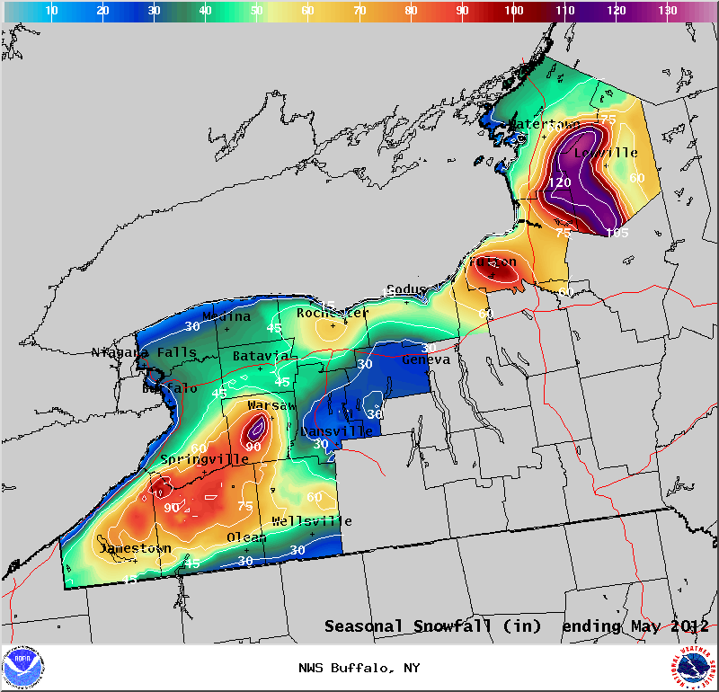
It can always be worse lol I need like 35" over the next 3 months to surpass these totals..
-
Upstate/Eastern New York
wolfie09 replied to BuffaloWeather's topic in Upstate New York/Pennsylvania
Idk I don't dabble in this witchcraft u guys call LR forecasting lol All I know is I haven't seen full grass since November. We still have 3 months to go, as bad as last year was I still finished with 177° for the year . We will pay for this in the long run when it's snowing into may.. -
Upstate/Eastern New York
wolfie09 replied to BuffaloWeather's topic in Upstate New York/Pennsylvania
Sneaky potential for a little LES on a NW flow behind the departing system...gif.93cd45d44e8a91ad326ed8073c4053a2.gif)
-
Upstate/Eastern New York
wolfie09 replied to BuffaloWeather's topic in Upstate New York/Pennsylvania
Ggem similar to the gfs with some west-wsw enhancement, especially the hills..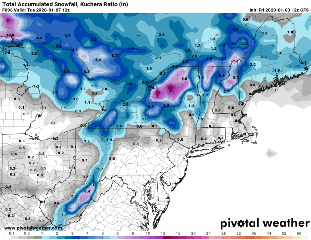

-
Upstate/Eastern New York
wolfie09 replied to BuffaloWeather's topic in Upstate New York/Pennsylvania
Ukmet goes over NJ into sne..
-
Upstate/Eastern New York
wolfie09 replied to BuffaloWeather's topic in Upstate New York/Pennsylvania
Bro did u not see the last page? The European was a cutter, the models are going total opposite lol -
Upstate/Eastern New York
wolfie09 replied to BuffaloWeather's topic in Upstate New York/Pennsylvania
Little bit of a late capture on the Canadian..thumb.png.5f40a3936051e1b78b19d4947d6abb12.png)
.thumb.png.5af1be6e6cd8b66d94c86576f7fb20ca.png)
-
Upstate/Eastern New York
wolfie09 replied to BuffaloWeather's topic in Upstate New York/Pennsylvania
This is all from Sunday/Monday on the gfs..imby.. Doesn't have much with the sat system..
-
Upstate/Eastern New York
wolfie09 replied to BuffaloWeather's topic in Upstate New York/Pennsylvania
Euro has not been stellar this year and I defend it all the time lol Just yesterday it has 6" for LI, sure just a blip but no other model had that issue lol -
Upstate/Eastern New York
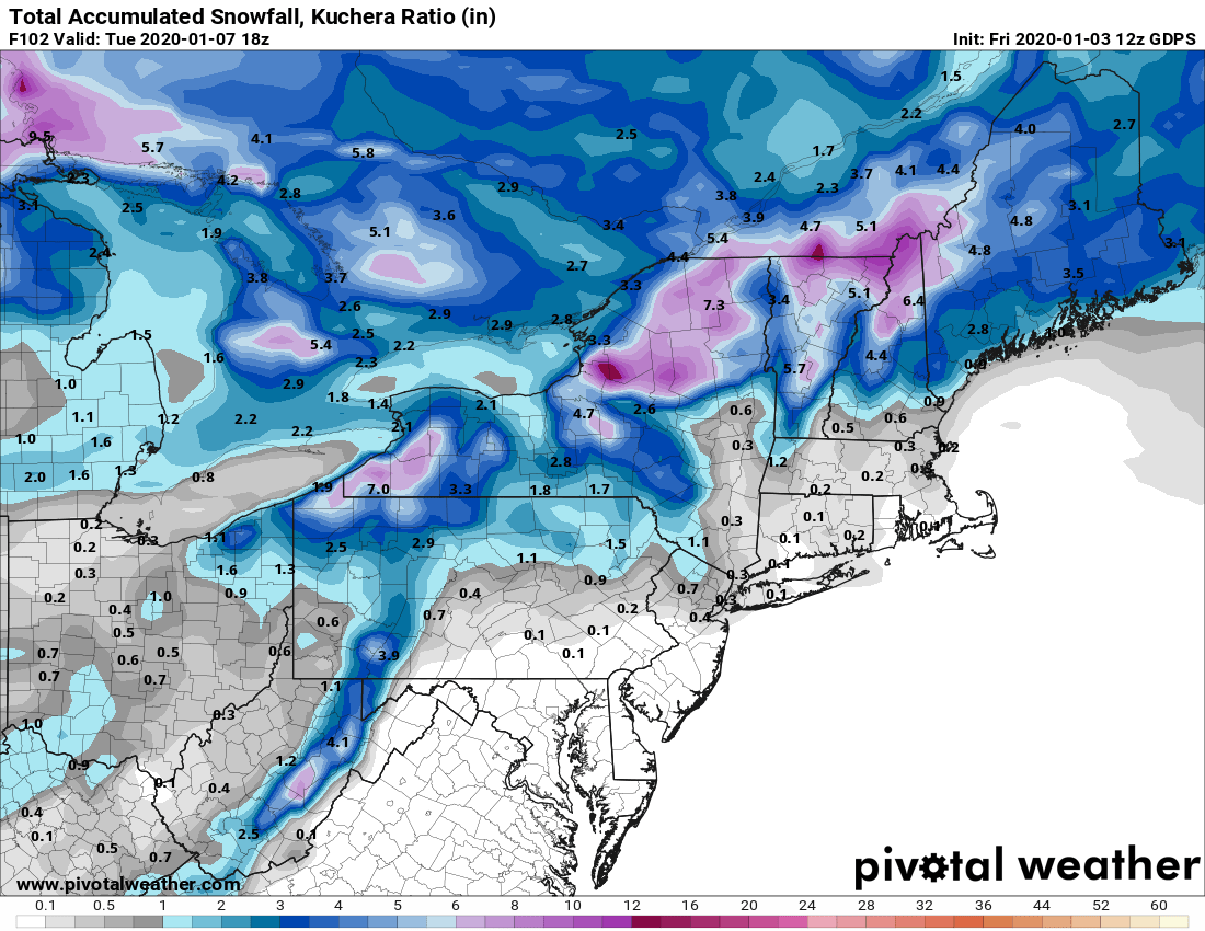
wolfie09 replied to BuffaloWeather's topic in Upstate New York/Pennsylvania
Last night's run...thumb.png.3e6fbf7fdaa48a1d47362fea7fcd199c.png)
.thumb.png.35cf987c0d75bc132185a19c41427263.png)
-
Upstate/Eastern New York
wolfie09 replied to BuffaloWeather's topic in Upstate New York/Pennsylvania
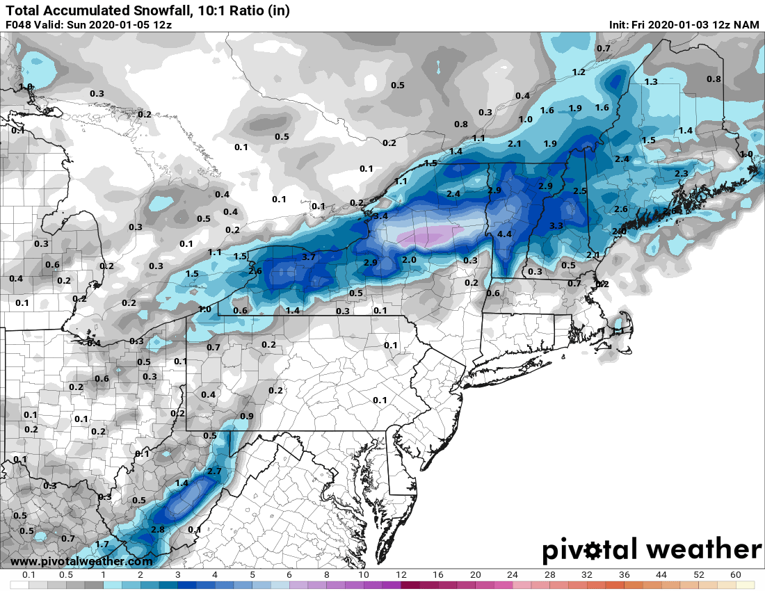
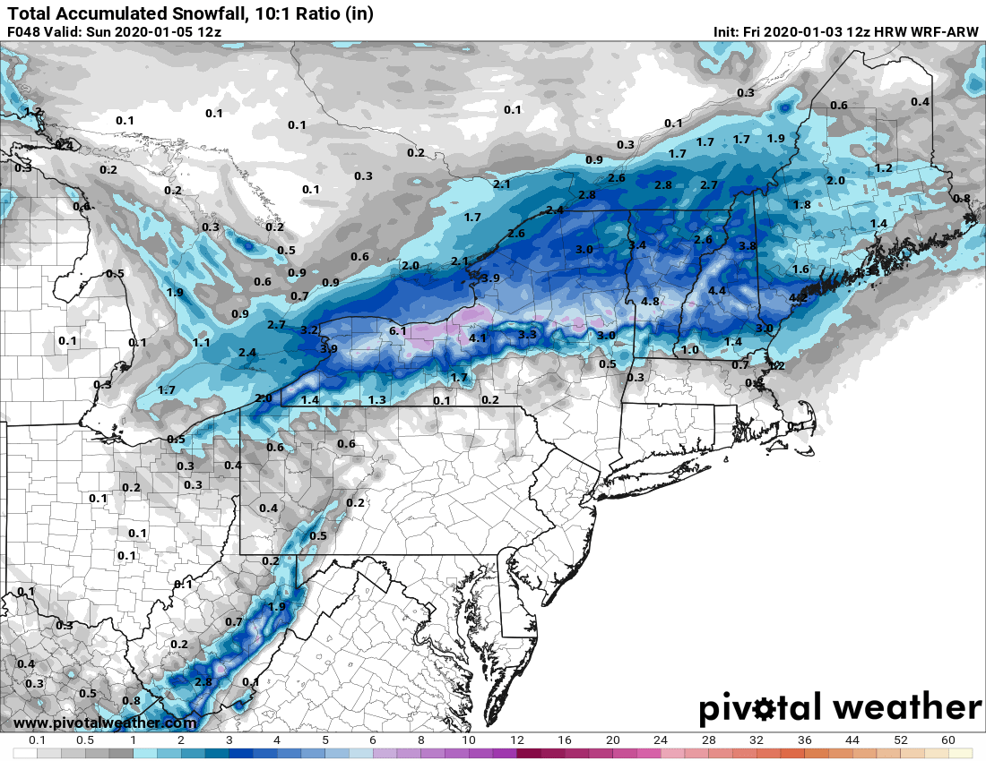
This was the European on Tuesday and Wednesday...thumb.png.9d02611621726a071a246500864d1a94.png)
.thumb.png.b392b69bbf2667066dd48f2b37dab240.png)
-
Upstate/Eastern New York
wolfie09 replied to BuffaloWeather's topic in Upstate New York/Pennsylvania
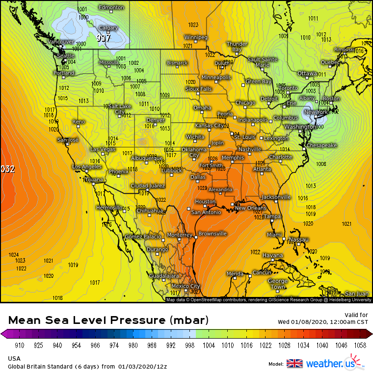
The next system is all about timing once again.. Gfs insistent on missing the phase.. Latest icon also just misses it..thumb.png.27aee8590dc316751126aa4a75da6740.png)
-
Upstate/Eastern New York
wolfie09 replied to BuffaloWeather's topic in Upstate New York/Pennsylvania
Concern for heavy snowfall continues to revolve around the potential phasing of northern and southern stream energy somewhere along the east coast during Saturday. Guidance continues to feature a variety of solutions in both the amount of phasing, as well as when this will occur, not to mention the resultant surface low track. There has been wide variability leading to lowered confidence in the forecast, and a trend towards the ensemble means remains prudent. That leaves a surface low which will lift northeast through Pennsylvania before transferring to secondary low development south of Long Island. If northern/southern stream phasing can occur early on Saturday, this low may track into the Gulf of Maine, but the trend has been for a more suppressed solution as the dynamics eject east quickly, allowing the surface low to remain weak and push off to the east as well. Initially the thermals will only support rain due to a warm column, with the exception being northern New England, but as the low pulls away cold air will wrap back towards the coast causing a p-type transition from rain to snow. The amount of precipitation available once the column cools remains in question, and at this time most of the snowfall is forecast to be light to moderate, with the highest amounts confined to the terrain. WPC probabilities for 6 inches are 30-50% in the Adirondacks, Greens, and Whites, with lesser amounts further to the south and at lower elevation. -
Upstate/Eastern New York
wolfie09 replied to BuffaloWeather's topic in Upstate New York/Pennsylvania
Continues to have that warm wedge into CNY.thumb.png.a88fa1b66738579367c79b7a3ea04866.png)
-
Upstate/Eastern New York
wolfie09 replied to BuffaloWeather's topic in Upstate New York/Pennsylvania
Rgem still all rain here lol Hi Rez Canadian is mostly snow. -
Upstate/Eastern New York
wolfie09 replied to BuffaloWeather's topic in Upstate New York/Pennsylvania
If we can stay at 33° or so I think we can see a couple /few inches, precip rates seem to be improving some...thumb.png.3d54efe8e46526adab4d0701835c639c.png)
.thumb.png.3d0de4b10fc0e3e7f06a6ff780c6896d.png)
-
Upstate/Eastern New York
wolfie09 replied to BuffaloWeather's topic in Upstate New York/Pennsylvania
Missing out on a decent event by 2-3 degrees..
-
Upstate/Eastern New York
wolfie09 replied to BuffaloWeather's topic in Upstate New York/Pennsylvania
It usually all comes down to precipitation rates, look at last event, sticking at 36-37 under heavy precip.. Hrrr has surface between 33-35 but rates probably won't get it done and the timing sucks.. -
Upstate/Eastern New York
wolfie09 replied to BuffaloWeather's topic in Upstate New York/Pennsylvania
Navy was one of the first (if not the first) to show this one going through NE PA...thumb.png.6b85e9f2f39c15debfd5aa7e40bccb40.png)

.png.7060d0ecf6d0035179e1abe6a0aa56a1.png)
.png.37ed5829e3b212e606a0641013a83acb.png)
.png.7a7b500ec30baf57da46169c4e8bdecf.png)
.png.e502612819ac798096cfbabeefddbe51.png)


.png.a64d77360b1855b1acd6e1414acd9505.png)
.png.1d8756bd320a7cd9a3bed87fa9d0b53f.png)
.png.30ae518395701b90f4355c89a18c4984.png)
.png.c3aef5f6f5f056ece1513942fd08838f.png)
.png.b70af57a2705ad395fdbf704e8c8bca8.png)
.png.a70ece9b6f399e5f1066cb2ca96e832b.png)
.png.7dbf54a9f91ab60bfdd6f042dbd5e206.png)
.png.161f992ef0bcaef05ef8766765caa42e.png)
.png.226541fd4f62f708762f992f87d676a0.png)
.png.13a91230b8c500f1cd6337d70fd8e144.png)