.jpeg.88e30b1573920286ceacf89f239564d2.jpeg)
wolfie09
-
Posts
17,315 -
Joined
-
Last visited
Content Type
Profiles
Blogs
Forums
American Weather
Media Demo
Store
Gallery
Everything posted by wolfie09
-
.thumb.jpeg.b9e232a6b43e01b7eeee3144246db864.jpeg)
Upstate/Eastern New York
wolfie09 replied to BuffaloWeather's topic in Upstate New York/Pennsylvania
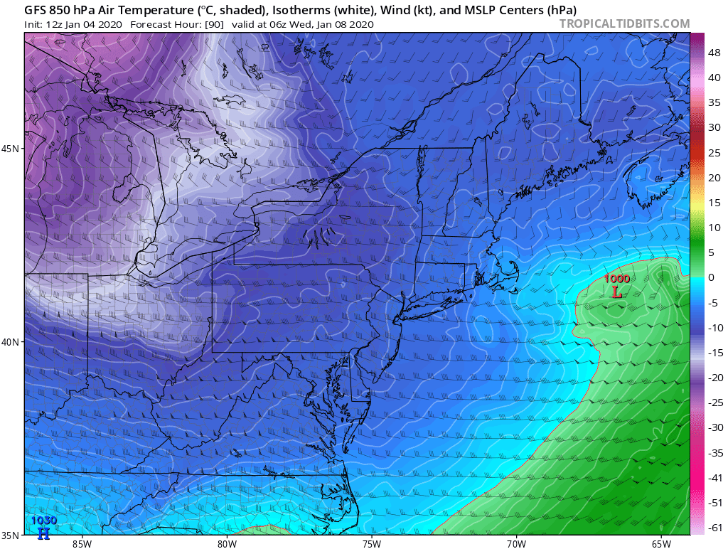
It's not a warm system especially since it's all northern stream..
-
Upstate/Eastern New York
wolfie09 replied to BuffaloWeather's topic in Upstate New York/Pennsylvania
Actually they are calling for all snow Tuesday night and Wednesday for ksyr, I guess they figure a little precip is possible during the day.. -
Upstate/Eastern New York
wolfie09 replied to BuffaloWeather's topic in Upstate New York/Pennsylvania
Which is funny because we see almost no precip on Tuesday.. It comes in overnight with temps in the mid 20s.. Precipitation amounts are a bigger concern...thumb.png.34d9c000495bebb9721cd894a1a77d69.png)
.thumb.png.3717a9c5f2ef082d829d6bd50879f55b.png)
-
Upstate/Eastern New York
wolfie09 replied to BuffaloWeather's topic in Upstate New York/Pennsylvania
The system moving through the area at the moment will continue to slide east as a mid-level trough quickly ushers it into New England this evening. Modest cold advection in its wake will feature northwesterly flow and fairly modest inversion heights. However, the top of the unstable layer does look to bisect the dendritic growth layer, and weak shear within the layer should promote some banding of snowfall off of the Great Lakes. There continues to be some semblance of concurrence amongst hi-res models with the development of a Georgian Bay band with a connection over western Lake Ontario that may emerge into the Buffalo Northtowns. Light snow accumulations were carried for this. As the night unfolds, bands should start to settle a bit south of there and in more typical lake effect areas with bands also finally forming off of Lake Ontario. Flow will really favor western Oswego County and northern Cayuga County, however unimpressive dendritic growth and crystal fracturing will probably hold back amounts there, but 2-3 inches seem possible. Elsewhere, accumulations will be spotty and light. The next system to affect the area will start to show its hand late Sunday afternoon and evening over western New York. A colder pre-arrival profile will be featured across the area. Potent upper level divergence is evident in the left exit region of an incoming jet streak, as well. Warm advection off the deck looks to be centered mostly below the dendritic layer over the Southern Tier and closer to it across the Thruway corridor. This will mean a bit better ratios across the northern two-thirds of the CWA than the southern third. Further, the best lift will generally translate down the Thruway and points to the north. Thus, system snowfall will generally be favored in the 2-4" range north and 1-3" range south. As the system advances eastward on Sunday night, westerly to west-southwest flow and a sharp, yet brief-lived, shot of cold advection off the deck follows. This should develop a nice band of WSW flow lake effect off of Lake Erie that will at least get into the Buffalo Southtowns, if not a bit farther north than that, along with the Chautauqua Ridge. A quick few inches with this band seem likely, however given the trend on new guidance as to this development, confidence on amounts and locations is fairly low. -
Upstate/Eastern New York
wolfie09 replied to BuffaloWeather's topic in Upstate New York/Pennsylvania
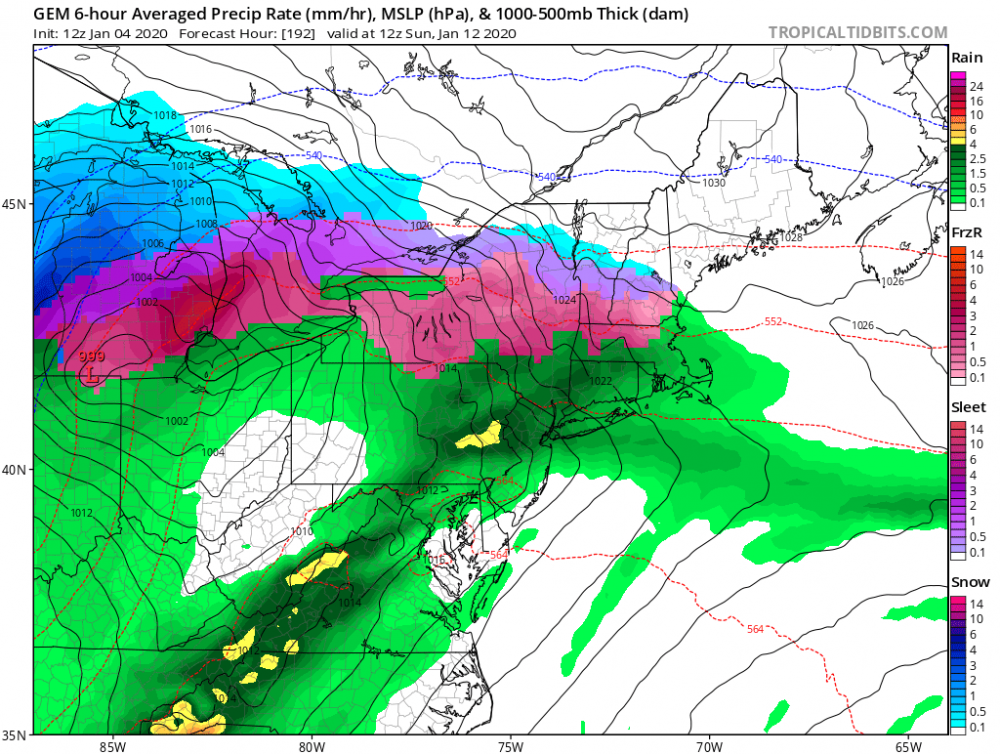
Yup and just like I figured, it waited for the HP to move out of the way lol That HP actually supplies us with some low level cold but with warm mid lvl we see a decent amount of ice...thumb.png.c4f7cf1524241d16814c9a7f0e3fdb59.png)
-
Upstate/Eastern New York
wolfie09 replied to BuffaloWeather's topic in Upstate New York/Pennsylvania
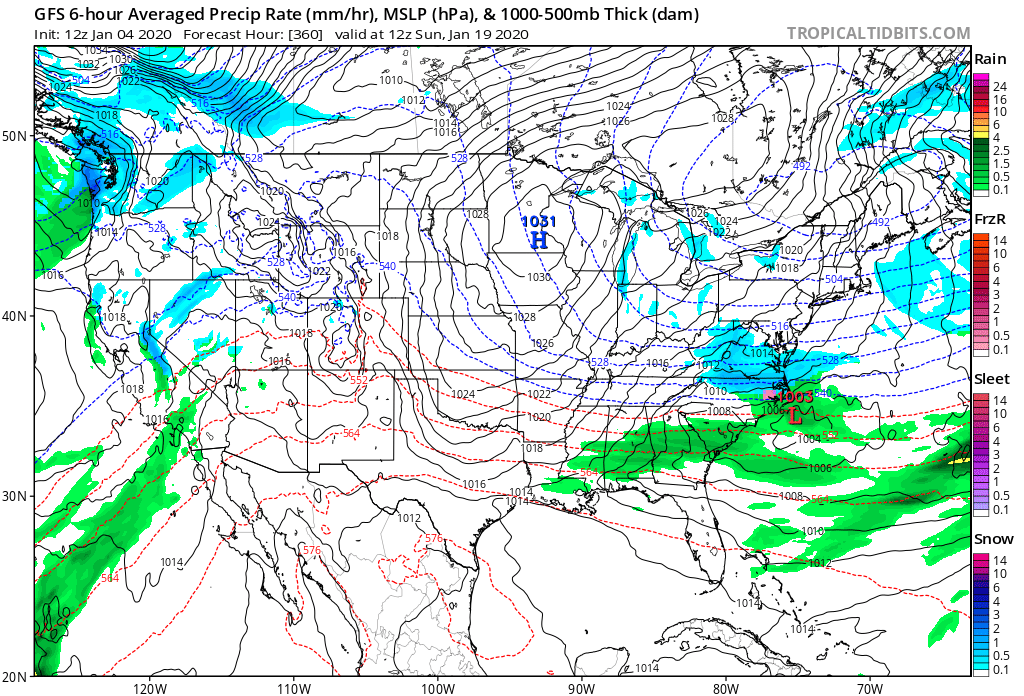
These 2 features will have a lot of say for the follow up event.. U can't cut with a 1036 mb HP over head lol And it can't head off the coast with the Bermuda high....thumb.png.383a3a9be3d6885c765a853f2862fa50.png)
-
Upstate/Eastern New York
wolfie09 replied to BuffaloWeather's topic in Upstate New York/Pennsylvania
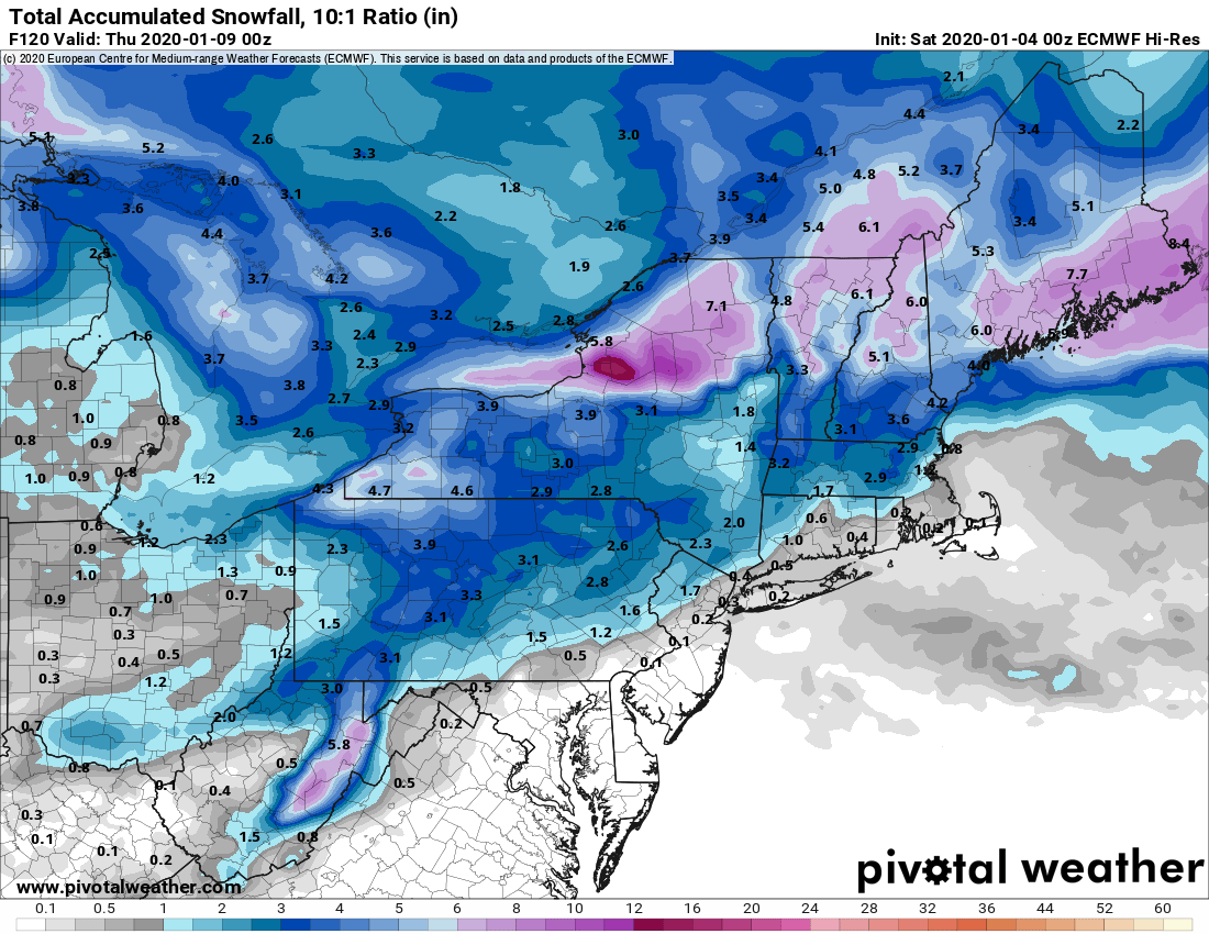
Euro!!! Shows absolutely nothing Unless u live on the tug, pretty much 1"-3" for most throughout the week... Another win for the gfs even though verbatim the gfs is better lol.thumb.png.e77f76659ec75d6b48120f7a001ad8b1.png)
-
Upstate/Eastern New York
wolfie09 replied to BuffaloWeather's topic in Upstate New York/Pennsylvania
And once we do start to get any cold air we will be dealing with suppression..lol
-
Upstate/Eastern New York
wolfie09 replied to BuffaloWeather's topic in Upstate New York/Pennsylvania
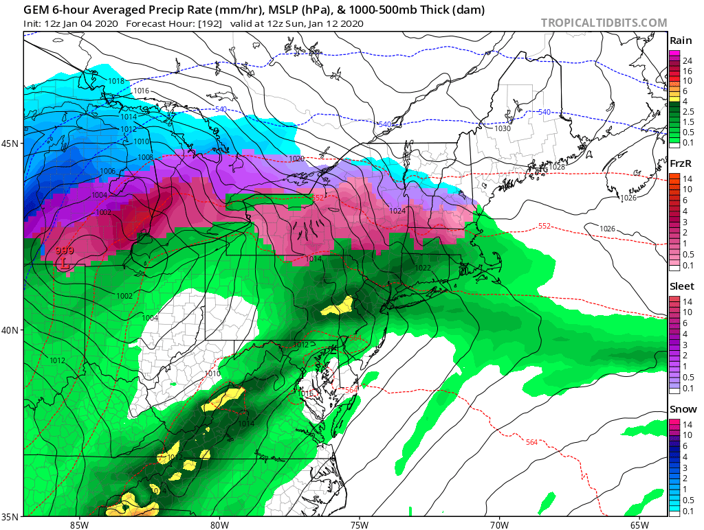
Canadian goes from ice to near 60 in like 6 hours lol..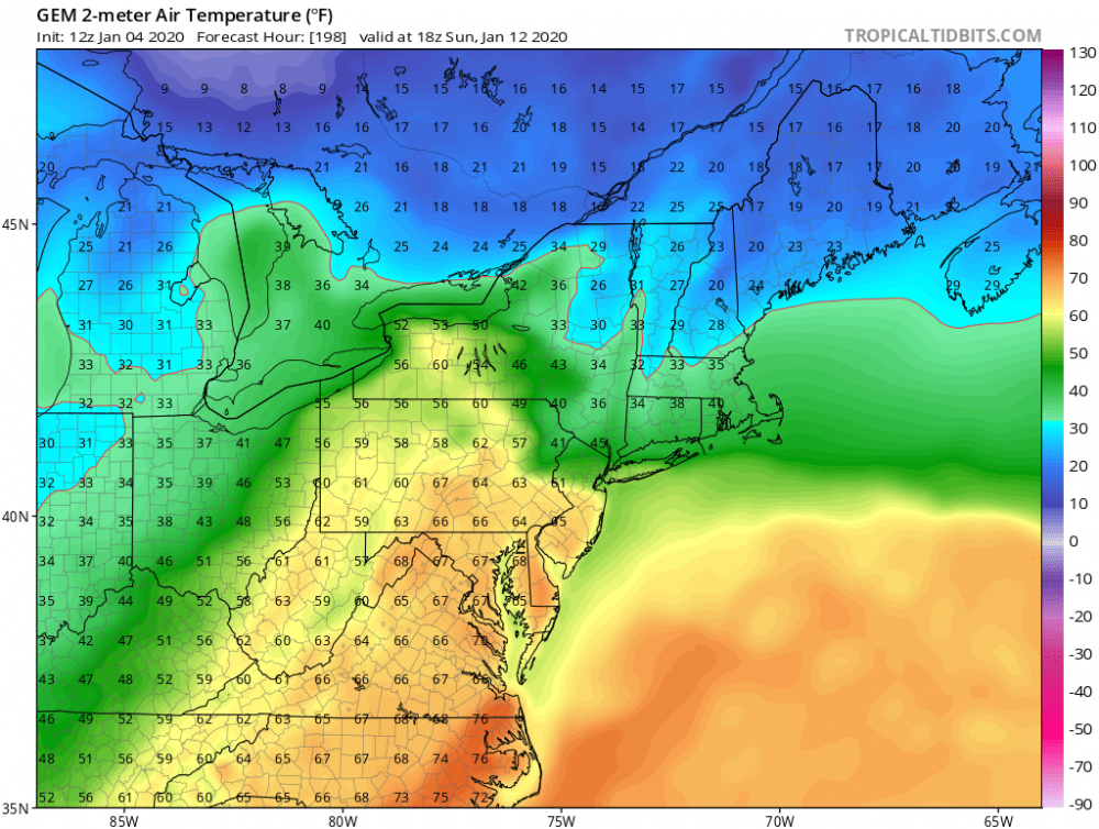
-
Upstate/Eastern New York
wolfie09 replied to BuffaloWeather's topic in Upstate New York/Pennsylvania
Normally that's exactly where we want to see LP lol It goes NE from there.. -
Upstate/Eastern New York
wolfie09 replied to BuffaloWeather's topic in Upstate New York/Pennsylvania
If that CF speeds up we won't be seeing much of anything as everything will shift east...HP is nosing down from Canada and SE ridge is retreating..It actually takes a decent track for WNY, right through Central PA, but we obviously have a marginal airmass...thumb.png.e8f420eb7e8788b6d940cf5bdc17994f.png)
-
Upstate/Eastern New York
wolfie09 replied to BuffaloWeather's topic in Upstate New York/Pennsylvania
Canadian phases off the coast of maine which seems to be the going trend.. -
Upstate/Eastern New York
wolfie09 replied to BuffaloWeather's topic in Upstate New York/Pennsylvania
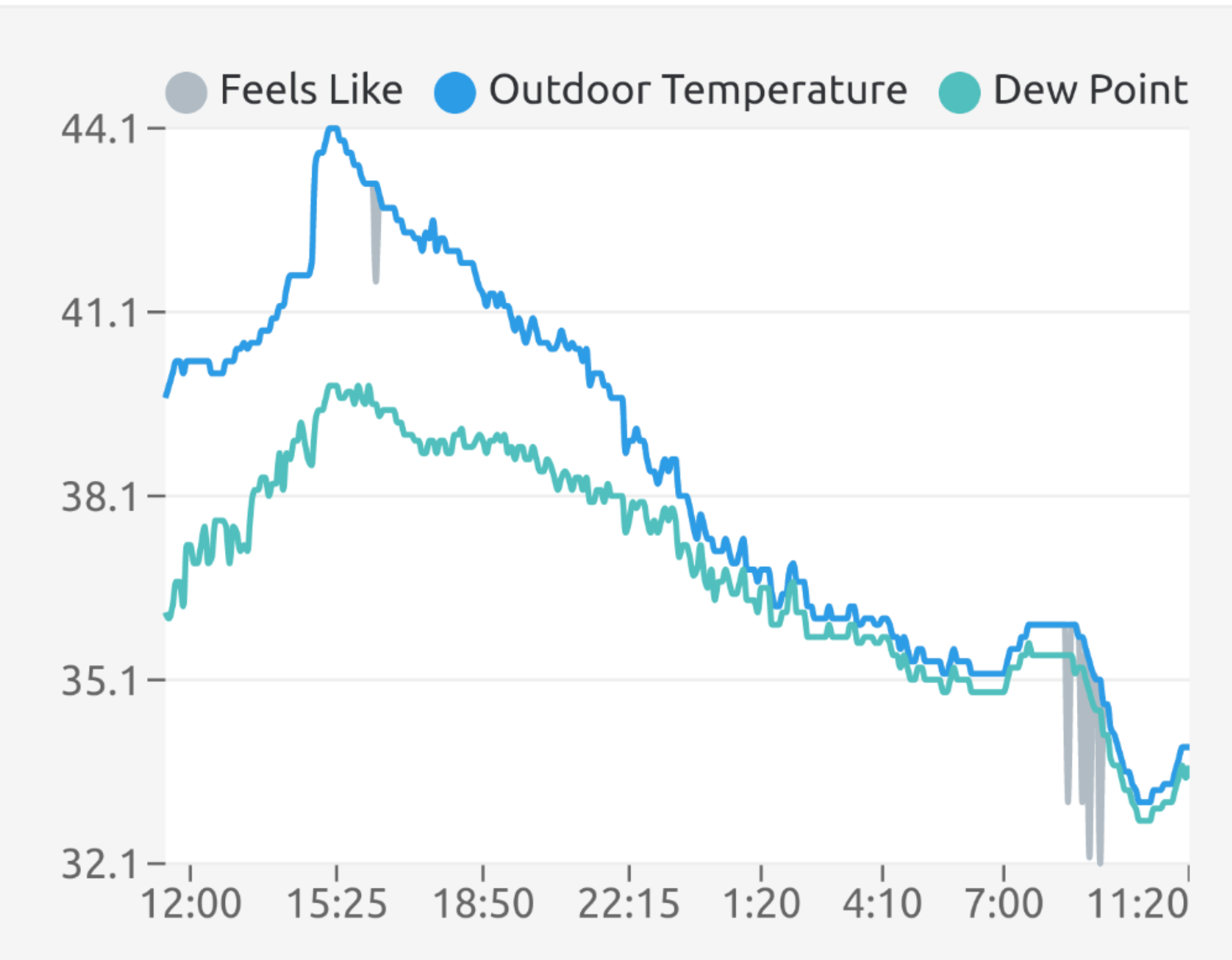
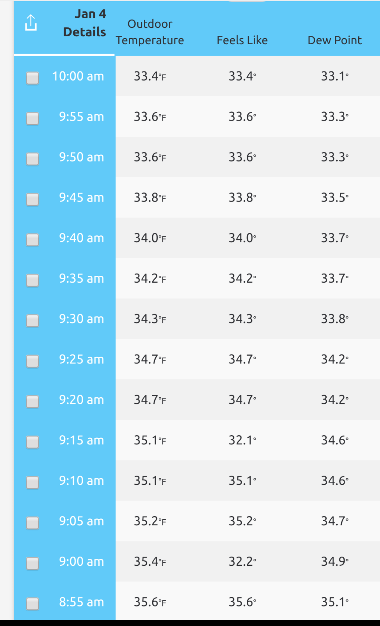
Temps here have actually gone up lol Probably due to the light precip rates.
-
Upstate/Eastern New York
wolfie09 replied to BuffaloWeather's topic in Upstate New York/Pennsylvania
I'm talking about the phase not the gfs OP run lol -
Upstate/Eastern New York
wolfie09 replied to BuffaloWeather's topic in Upstate New York/Pennsylvania
Not going to happen...thumb.png.05381911c2b4a7334eba9993cbd52b3c.png)
-
Upstate/Eastern New York
wolfie09 replied to BuffaloWeather's topic in Upstate New York/Pennsylvania
Kbgm A more wintry and somewhat active period expected, with near average temperatures. QPF amounts should be between 0.05-0.20" for much of the area, and with snow to liquid ratios around 10-15:1 we are forecasting a general 1-2 inches of snow overnight. South-southwest winds 8-15 mph could cause localized blowing snow at times as low temperatures dip into the 20s. A steadier area or band of lake effect snow is also possible across portions of Oneida county on a 270 degree boundary layer flow. Could see an additional 1-3 inches of snow up here through the day -
Upstate/Eastern New York
wolfie09 replied to BuffaloWeather's topic in Upstate New York/Pennsylvania
Best chance for NW flow is this evening..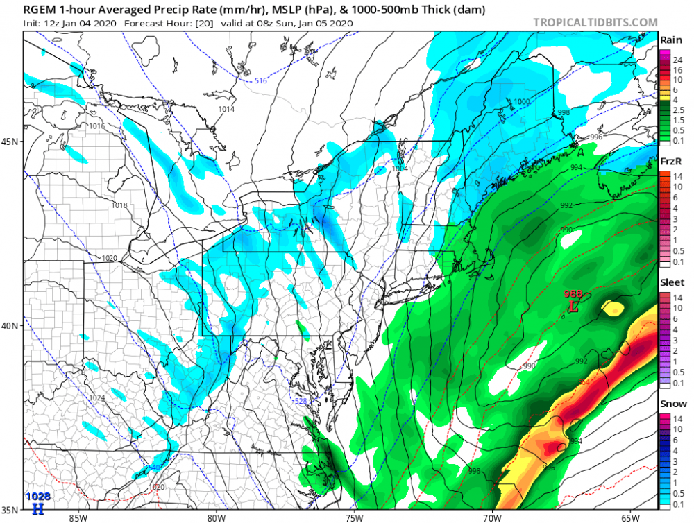
-
Upstate/Eastern New York
wolfie09 replied to BuffaloWeather's topic in Upstate New York/Pennsylvania
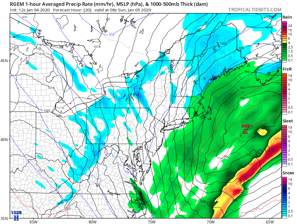
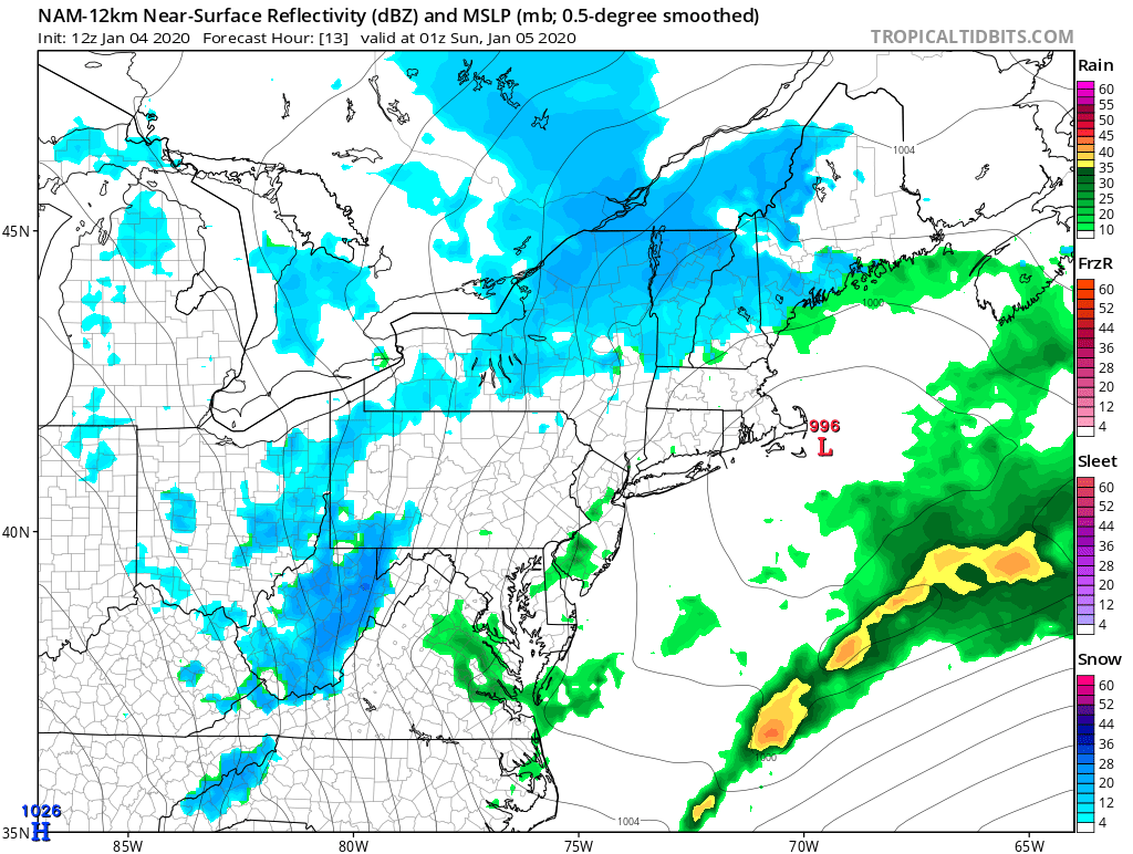
Be interesting to see if the NAM has a clue (probably not) radar starts to "backfill" as the systems phase off the coast..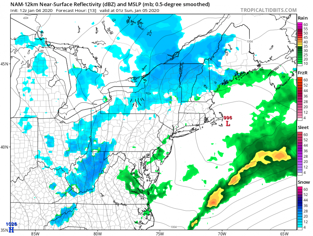
-
Upstate/Eastern New York
wolfie09 replied to BuffaloWeather's topic in Upstate New York/Pennsylvania
Ripping here atm, unfortunately won't be lasting much longer...gif.8936042730f9e490ead2c09c65d4c281.gif)
-
Upstate/Eastern New York
wolfie09 replied to BuffaloWeather's topic in Upstate New York/Pennsylvania
Wind direction is 306° which is pretty cool to be able to see lol That's a NW wind if u need to know haha -
Upstate/Eastern New York
wolfie09 replied to BuffaloWeather's topic in Upstate New York/Pennsylvania
Snow starting to stick on the colder surface as temps slowly drop..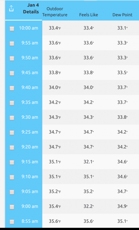
-
Upstate/Eastern New York
wolfie09 replied to BuffaloWeather's topic in Upstate New York/Pennsylvania
We could still manage some lake effect even if we have a late phase which is exactly what the European shows.. Small window but it would be better than nothing....thumb.png.e6adfd61e6f864deb5b0c0bf9736c54b.png)

-
Upstate/Eastern New York
wolfie09 replied to BuffaloWeather's topic in Upstate New York/Pennsylvania
Wasted 0.08" liquid on rain... -
Upstate/Eastern New York
wolfie09 replied to BuffaloWeather's topic in Upstate New York/Pennsylvania
Flipping to snow in Pulaski, big fatties.. -
Upstate/Eastern New York
wolfie09 replied to BuffaloWeather's topic in Upstate New York/Pennsylvania
Euro is going to be 1.5'-2' for everyone through its run .. We toss lol

.png.8a180d3a2a434df56aaee564e74dd42c.png)
.png.5d4ce0951ed80145c5636802c59bf8b2.png)
.png.9db0648df56fde15804d6d6dcf52534f.png)
.png.4df44b6021bf27723de3d6ce81ff6b30.png)
.png.a3ef429c13fee7b9f3cb4e8801d417a9.png)


.png.ea08478bc178cc481d89496af85aca99.png)

.png.67e3c8910fb937fbfd6b58248f0006aa.png)
.png.ec06d4722b9a246a865910c4d94b0809.png)