.jpeg.88e30b1573920286ceacf89f239564d2.jpeg)
wolfie09
-
Posts
17,315 -
Joined
-
Last visited
Content Type
Profiles
Blogs
Forums
American Weather
Media Demo
Store
Gallery
Everything posted by wolfie09
-
.thumb.jpeg.b9e232a6b43e01b7eeee3144246db864.jpeg)
Upstate/Eastern New York
wolfie09 replied to BuffaloWeather's topic in Upstate New York/Pennsylvania
They actually just signed the Pats WR coach lol Young guy 39, learned under saban and belichick, so we'll see how that one turns out.. -
Upstate/Eastern New York
wolfie09 replied to BuffaloWeather's topic in Upstate New York/Pennsylvania
Even navy cuts.. -
Upstate/Eastern New York
wolfie09 replied to BuffaloWeather's topic in Upstate New York/Pennsylvania
At this range GFS is an outlier lol -
Upstate/Eastern New York
wolfie09 replied to BuffaloWeather's topic in Upstate New York/Pennsylvania
Cmc looks just like the European.. -
Upstate/Eastern New York
wolfie09 replied to BuffaloWeather's topic in Upstate New York/Pennsylvania
-
Upstate/Eastern New York
wolfie09 replied to BuffaloWeather's topic in Upstate New York/Pennsylvania
-
Upstate/Eastern New York
wolfie09 replied to BuffaloWeather's topic in Upstate New York/Pennsylvania
Timmy program the 12z gfs? 9.3" verbatim using kuchera..lol -
Upstate/Eastern New York
wolfie09 replied to BuffaloWeather's topic in Upstate New York/Pennsylvania
Close to a decent burst on the backside.. -
Upstate/Eastern New York
wolfie09 replied to BuffaloWeather's topic in Upstate New York/Pennsylvania
Rgem has nice looking band setting up for a few hours early this morning, tempted to wake up and take a glance out side lol -
Upstate/Eastern New York
wolfie09 replied to BuffaloWeather's topic in Upstate New York/Pennsylvania
It depends how it gets there.. If it goes NE through PA into the southern tier of ny it will be more wintry.. Or it can be like the European and go due north and then make a hard right through southern NY= Rain -
Upstate/Eastern New York
wolfie09 replied to BuffaloWeather's topic in Upstate New York/Pennsylvania
Gettleman is a control freak, no coach is gonna deal with that.. -
Upstate/Eastern New York
wolfie09 replied to BuffaloWeather's topic in Upstate New York/Pennsylvania
When this process first started the 3 "favorites" were , rhule, McCarthy and Rivera, all gone lol McDaniels ain't leaving the pats, basically leaves them the balt coordinator lol -
Upstate/Eastern New York
wolfie09 replied to BuffaloWeather's topic in Upstate New York/Pennsylvania
Giants are the worst run organization in football lol They interview like 15 candidates while all these other teams are snatching up these coaches, we'll get stuck with Jason Garrett, watch lol -
Upstate/Eastern New York
wolfie09 replied to BuffaloWeather's topic in Upstate New York/Pennsylvania
Yeah tell me about it lol Couple decent totals from yesterday 1 NW Constableville 11.0 400 AM 1/07 CoCoRaHS Redfield 8N 9.4 700 AM 1/07 Co-Op Observer -
Upstate/Eastern New York
wolfie09 replied to BuffaloWeather's topic in Upstate New York/Pennsylvania
-
Upstate/Eastern New York
wolfie09 replied to BuffaloWeather's topic in Upstate New York/Pennsylvania
Here was the 3k -
Upstate/Eastern New York
wolfie09 replied to BuffaloWeather's topic in Upstate New York/Pennsylvania
This was the rgem for last night...thumb.png.cd1d60033fcd7f7c9ed1df94b1074619.png)
-
Upstate/Eastern New York
wolfie09 replied to BuffaloWeather's topic in Upstate New York/Pennsylvania
Or last year when the models were nailing me and Matt on multiple occasions for it to end up near Watertown.. Rgem nailed everyone of them.. -
Upstate/Eastern New York
wolfie09 replied to BuffaloWeather's topic in Upstate New York/Pennsylvania
Funny cause it was the only model to predict you getting snow from that meso.. -
Upstate/Eastern New York
wolfie09 replied to BuffaloWeather's topic in Upstate New York/Pennsylvania
Rgem is the best lake effect model we have and it's not even close lol -
Upstate/Eastern New York
wolfie09 replied to BuffaloWeather's topic in Upstate New York/Pennsylvania
Not much in the way of sustained lake effect. -
Upstate/Eastern New York
wolfie09 replied to BuffaloWeather's topic in Upstate New York/Pennsylvania
Kbuf doesn't sound to enthused, which may be a good thing lol A very brief shot of sub arctic air will glance our forecast area Wednesday night...as the supporting mid level trough will race to the east across New England. A secondary cold front will drop south across Lake Ontario Thursday evening...and this will give us a glimpse of H85 temps of -18 to -20c. The corresponding instability over the wide open lakes will then combine with some channelled vorticity and short lived upstream connections to allow for some accumulating snows southeast of both lakes. Snow accumulations will be severely limited though by a low cap...with a staunch subsidence inversion dropping from 5 and 8kft over Lakes Erie and Ontario respectively. While there will be an abundance of moisture in the snow dendritic growth zone under the entire layer beneath the inversion...snow accumulations will be severely limited though by a low cap. A staunch subsidence inversion will drop from 5kft over Lake Erie with only a slightly more favorable initial convective depth of 8kft over Lake Ontario. The low sheared 300 flow will be primed off Lake Huron and Georgian Bay...but these connections will be torn apart after 06z as a broad ridge over the Upper Great Lakes will advance east and quickly establish a warm advective pattern. Nighttime snow accums will only be in the vcnty of an inch or two between Rochester and Syracuse...with lesser amounts over the Western Southern Tier. Otherwise... -
Upstate/Eastern New York
wolfie09 replied to BuffaloWeather's topic in Upstate New York/Pennsylvania
Another minor event.thumb.png.3f044b857b96b5154d0f3f337b970994.png)
-
Upstate/Eastern New York
wolfie09 replied to BuffaloWeather's topic in Upstate New York/Pennsylvania
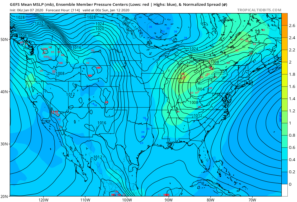
Gfs mean and spread still pretty far west..
-
Upstate/Eastern New York
wolfie09 replied to BuffaloWeather's topic in Upstate New York/Pennsylvania
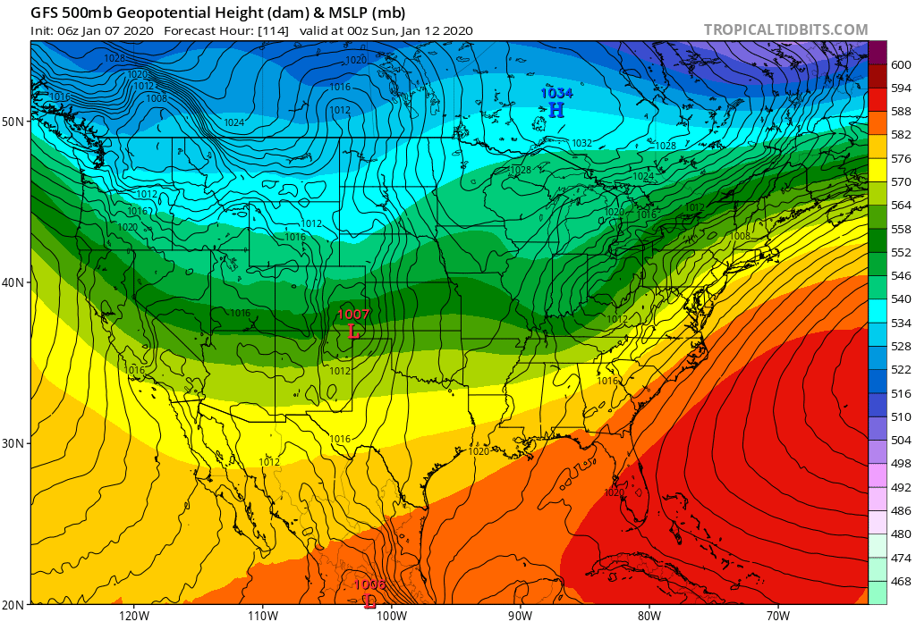
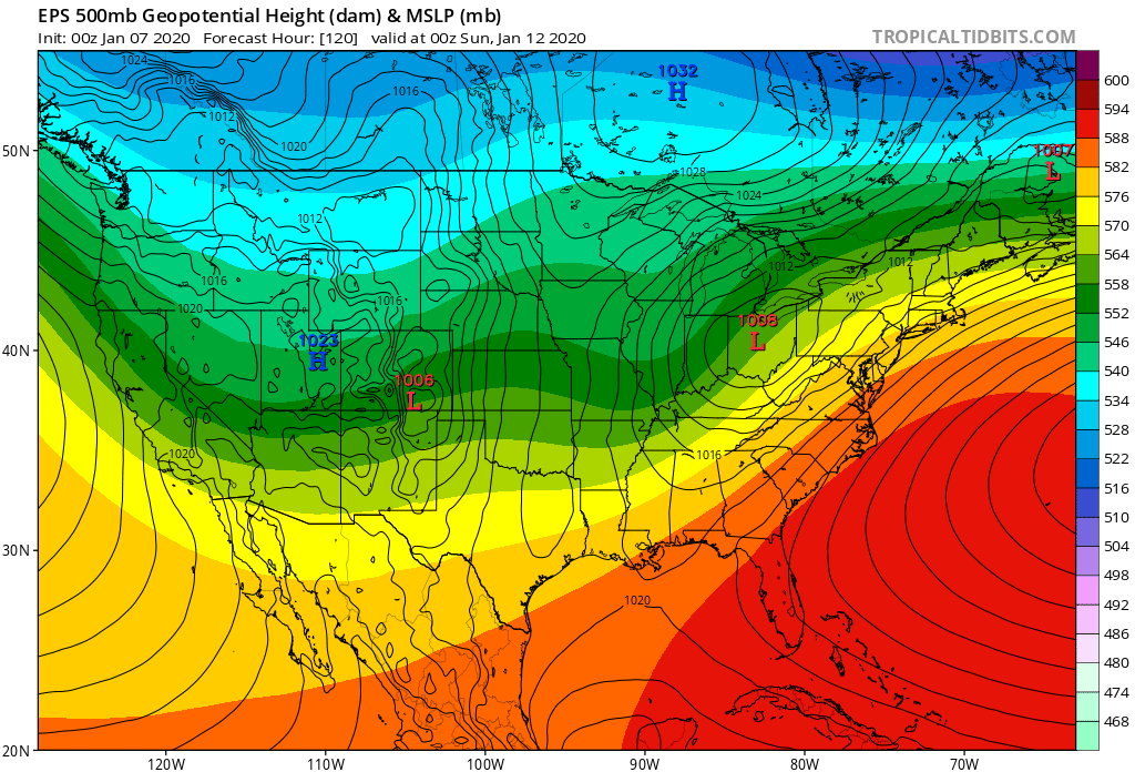
Eps not that much different from the gfs OP.. Obviously I don't know where it goes from here.. Eps just a little north and weaker with HP..


.png.ed64b29516f0795f79c3386be34260a0.png)
.png.cb6ba484648944dda2be66a188f7510e.png)