

mattinpa
-
Posts
2,494 -
Joined
-
Last visited
Content Type
Profiles
Blogs
Forums
American Weather
Media Demo
Store
Gallery
Posts posted by mattinpa
-
-
8 minutes ago, North and West said:
I always preface this with I hope that I’m wrong, but why would you believe this after nothing has gone in the favor of snow this year?
Until proven wrong, I don’t believe it.
.In most winters, there is something even if minor. So chances are something will surprise.
-
 1
1
-
-
1 minute ago, EastonSN+ said:
This would be a kick to the Giblets

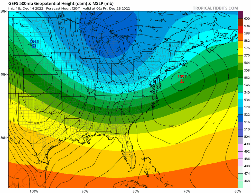
At least it is the GFS and shows a suppressed system. Things have been correcting more north - too north and west in fact.
-
1
-
-
1 minute ago, Wxoutlooksblog said:
If there was a chance with any of this series of storm systems (yesterday, 22-23, 25-26) I would have said 25-26 would be our best chance because of the high pressure to the north. But look how quickly it disappears. Now if it holds in place much longer, different story. But we would also have to get a coastal to develop quickly to lock the cold air in at lower levels and it would have to develop in exactly the right spot offshore. It's a tall order at this point IMO.
WX/PT
Yeah at least there is the high which makes something measurable doable IMO - but wouldn’t be surprised if shut out again.
-
5 minutes ago, eduggs said:
Yeah I think we're screwed for the forseeable future. Maybe far N&W gets a little something. I don't see anything promising right now. Not Monday, not Wednesday, not deep into the extended. Maybe it cools down at some point, but there are no distinct and promising threats.
Ensembles still say the City has a chance of stealing an inch here or there. I'm doubtful of even that low threshold for the time being.
End of month/early Feb looks like a possibility. Of course there is always a chance that goes away like the other periods.
-
1
-
-
3 minutes ago, JTA66 said:
Same here.
Yep, lightning and a loud clap of thunder here. So depressing for January.
-
4 minutes ago, Winterweatherlover said:
Kind of surprised the Euro is the model trolling us but Euro says you can keep dreaming next week especially inland
Considering all I have gotten is a brief snow squall on Christmas Eve, this would feel like a major storm.
-
3 hours ago, snowman19 said:
Evidence growing for March to be the “real” winter month here….Looks like the MJO will propagate out into the Pacific come early March, based on the Paul Roundy plots Eric shows, the possible SSW event in early February (takes awhile/weeks with the lag to actually have an effect) couples with the troposphere, cold rebuilds in Canada, SPV weakens greatly, -NAO/-AO, also, possible jet extension and +PNA. The caveats….it will be March, so March “cold”, and March climo, also sun angle and length of day will be working against us, so keep expectations tempered, but I think it ends up being the most wintry (cold/snow) month of 22-23. Will have to re-examine as we get closer. Still very strongly believe February is canonical La Niña/-PNA/SE ridge/flat Aleutian ridge and well above normal temps, well below normal snow
Well, if it does turn out that way, and we will see - I hope March is cold enough so the snow doesn’t just melt right away.
-
1 minute ago, Wxoutlooksblog said:
So it's right on the NJ shoreline.
WX/PT

Looks like something to track finally. While I do not expect this to turn into a good winter, as December showed, we could still have periods where we can cash in if things go right.
-
2
-
-
10 minutes ago, donsutherland1 said:
I suspect that temperatures will cool, but it remains uncertain whether there will be any significant Arctic air through perhaps mid-January. Much can still change.
Thanks for keeping on top of it. I enjoy your write ups a lot. Yes, what is coming up likely isn’t sustainable for a whole month, but we will have to see how cold it gets and if it snows. We don’t need it to be teens for highs like on Christmas Eve.
-
1
-
-
4 hours ago, donsutherland1 said:
The mercury pushed into the middle 30s today as warmer air began overspreading the region. Tomorrow, the thermometer will very likely break 40°. By the end of the week, temperatures could reach or exceed 50° in much of the area. The first week of January will likely see much above normal temperatures across the region. The week will likely see readings average 5°-10° above normal.
Although some of the guidance suggests that stratospheric warming could commence during the second week of January, skill scores at that range, even before considering whether the warming would be sufficient to displace or split the polar vortex, are low. Thus, while the second week of January could see some cooling from the first week's exceptional warmth, a cold outcome is not assured. Indeed, the latest EPS weeklies illustrate the idea that a cold outcome isn't assured.
It appears increasingly very likely that 2022 will become the 14th year during which New York City receives no measurable snowfall through December 31. During the 13 prior years, mean seasonal snowfall was 16.0" (median seasonal snowfall: 16.3"). Just 8% of those winters rallied to see 30" or more seasonal snowfall. 31% of those winters wound up with less than 10" of seasonal snowfall. Just under half (46%) had 20" or more seasonal snowfall. The lowest seasonal snowfall for those cases of 2.8" was recorded in 1972-1973. The highest seasonal snowfall for those cases was 32.8", which occurred during 2015-2016.
The ENSO Region 1+2 anomaly was -0.1°C and the Region 3.4 anomaly was -0.8°C for the week centered around December 21. For the past six weeks, the ENSO Region 1+2 anomaly has averaged -0.73°C and the ENSO Region 3.4 anomaly has averaged -0.88°C. La Niña conditions will likely persist through mid-winter.
The SOI was +19.56 today.
The preliminary Arctic Oscillation (AO) was -0.937 today.
On December 25 the MJO was in Phase 5 at an amplitude of 1.957 (RMM). The December 24-adjusted amplitude was 1.868 (RMM).
Based on sensitivity analysis applied to the latest guidance, there is an implied 98% probability that New York City will have a colder than normal December (1991-2020 normal). December will likely finish with a mean temperature near 37.7° (1.4° below normal).
Hi Don - I hope we do get cold by mid Jan because we’d really be wasting peak winter time.
-
2
-
-
Fortunately winds were pretty light here and got to see a snow squall before Christmas. Currently 7 here.
-
Can someone explain exactly what went wrong when we had such blocking? Bad SE ridge orientation?
-
10 minutes ago, Ralph Wiggum said:
Ironically, the gefs are slightly improved if not a decent bit better especially wrt mean lp and mean snow amounts.

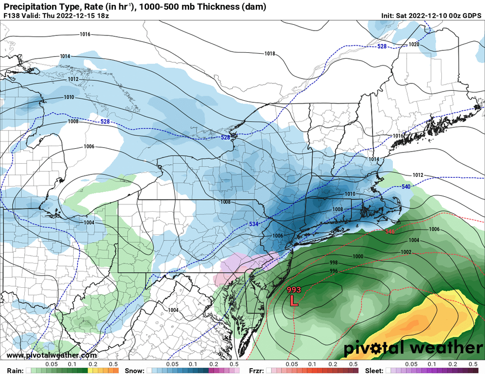
Interesting. Yes, the GFS showed rain, but its evolution was still different than the other models.
-
8 minutes ago, winterwx21 said:
Euro just came in warmer. Rain for most of us. You have to go well to the NW to see the snow on this run, similar to today's storm. Definitely not what we wanted to see tonight with these rainy runs (except for GFS), considering these things tend to trend NW as they get closer.
It’s still well early enough for corrections. I did like seeing the GFS east. I hope they don’t all go to a cutter and stay there - we have seen that happen a lot.
-
1
-
-
16 minutes ago, Ralph Wiggum said:
Im just trying to keep my expectations in check. Been better at this since 2012. Are all the ingredients present for a potential MECS/HECS? Yes. Does that equate to a lock? Absolutely not. We do get these looks every once in a while. Some work out, most turn out to be SECS here due to timing/spacing issues. It still takes a perfect setup to get a perfect storm, lets not forget that. Lets just see how this one plays out.
I’m definitely excited - the last White Christmas in Philly was in 2009 - but correct that we still need a lot of features in place to get a MECS/BECS.
-
1 hour ago, jm1220 said:
And the same exact neighborhoods were hit in March of this year.
My thoughts are with them. December tornadoes again. My region was hit bad last year (2021) but fortunately I avoided everything but some flooding nearby.
-
1
-
-
2 hours ago, SnoSki14 said:
 GEFS show multiple threats
Hopeful for sure. People were talking about late December being more favorable.
-
1
-
-
1 hour ago, Birds~69 said:
Being in Reading, I would think you get at least a little something frozen...
37F/Cloudy
Yeah might even be some down where we are even if sleet. Hoping to at least get something measurable.
-
4 minutes ago, MJO812 said:
What a wild storm on the euro
Long duration
Snow? I don’t have the Euro maps. Thanks for the updates.
-
40 minutes ago, SnoSki14 said:
The GFS went from a deep trough to ridge in one run. The GFS is garbage
True. I still think we have a decent chance for snow in the next couple weeks.
-
5 minutes ago, HeadInTheClouds said:
GFS shows nothing once again and is a sheared out mess. CMC still has the storm.
GFS is a bit Grinchy overall. Colder before cutters and rain through Christmas.
-
39 minutes ago, Newman said:
There's some pretty big solutions showing up on the GEFS, especially for the interior but even some for the coast
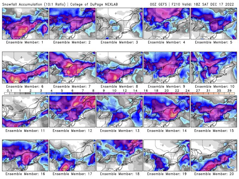
I’ll take Ensemble member 20
-
3
-
-
Any worry about wind or severe storms from the hurricane remnants?
-
1 minute ago, 495weatherguy said:
I think people use the word torch incorrectly. I like for a torch, relative to normal. 45-50 degrees is fine for the winter. What I don't care for much anymore is the 15 degree days with a bone chilling wind. Snow used to melt within a week. For those who want deep winters, this is not the area for you---especially if you are near the coast--we don't live in Maine.
I’m not the biggest 15 degree fan but I personally like it more than 100 degrees. I prefer good snow temps and snowy winters.
-
 1
1
-

E PA/NJ/DE Winter 2022-2023 OBS Thread
in Philadelphia Region
Posted
So that’s what snow looks like! Moderate snow that looks pretty. Just a dusting so far.