

mattinpa
-
Posts
2,561 -
Joined
-
Last visited
Content Type
Profiles
Blogs
Forums
American Weather
Media Demo
Store
Gallery
Posts posted by mattinpa
-
-
4 hours ago, Eduardo said:
Who wouldn’t expect that at this point? Def a notable trend.
Whether it is or isn’t, it is still a milestone to get to September IMO. Maybe we’re due for a cooler one.
-
 1
1
-
-
1 hour ago, Wxoutlooksblog said:
Don't be so sure. For now yes there's no heat in sight. But remember, 1955 started out very very slowly in terms of heat and featured a blocking pattern like we've had this June. And they ended up with 14 90+ days in July and 10 90+ days in August. Frankly, if the pattern does flip, you can reverse that for this summer (if the pattern flips) and make it 10 in July and 14 in August, then add a few in September. It *could* happen, not saying that it will.
WX/PT
Agree. I personally hope for a cooler summer, but met summer just started. Can’t September even have our hottest temperature?
-
 1
1
-
-
8 hours ago, Hurricane Agnes said:
Thanks for that update! Agree that tornado alley has been moving east and especially on your side of the river!


Yeah, it seems like many storms strengthen and hit NJ the hardest. Hopefully it will just me mild tornadoes if the region gets more. Last year with the EF3s and EF2s was unusual.
-
Pouring rain but not bad wind yet..
-
Under a severe thunderstorm warning now
-
1 minute ago, RedSky said:
The Berks storm seems to be weakening much less lightning strikes possibly the first round out ahead of it stabilized the atmosphere
Anything severe headed for Royersford? It is hard to tell if the one storm is going to the north of here.
-
26 minutes ago, Birds~69 said:
Cool thunder, wind and downpours but no lightning which was a tad odd? Cool event though...
Same here. Not much lightning at Royersford. It was pretty intense with that rain though.
-
That line did indeed hit here; very heavy rain and moderate wind gusts. That was with the severe thunderstorm warning.
-
9 minutes ago, RedSky said:
High winds were reported in the cell west of Lancaster
Is that cell headed towards me or to the north?
-
4 hours ago, donsutherland1 said:
The warmth will crest tomorrow. Under partly sunny skies, thermometers will soar into the upper 70s and even lower 80s in much of the region. The south shore of Long Island and the Connecticut shore could be exceptions where it is cooler. A shower or thundershower is possible.
Overall, tomorrow through Friday will generally be warmer to much warmer than normal. There could be brief interruptions of the warmth from backdoor cold fronts.
A blizzard continues to impact the Northern Plains. Parts of North Dakota could see 1-2 feet of snow with locally higher amounts near 3 feet by the time the storm ends tonight or tomorrow. Drifts in excess of 6 feet are likely.
The ENSO Region 1+2 anomaly was -1.1°C and the Region 3.4 anomaly was -0.9°C for the week centered around April 6. For the past six weeks, the ENSO Region 1+2 anomaly has averaged -0.73°C and the ENSO Region 3.4 anomaly has averaged -0.92°C. La Niña conditions will likely persist into the start of May.
The SOI was +25.74 today. Today was the 9th consecutive day that the SOI was +20.00 or above. The last time that happened was December 20-28, 2011 when the SOI reached +20.00 or above on 9 consecutive days. The last time a streak of 7 or more such days occurred in April was March 28-April 5, 2011 when the SOI reached at least +20.00 on 9 consecutive days. Then, there was a brief period of much warmer than normal temperatures following the end of that stretch and a longer period of much warmer than normal temperatures starting about 2 1/2 weeks later.
The preliminary Arctic Oscillation (AO) was -0.968 today.
On April 11 the MJO was in Phase 7 at an amplitude of 0.712 (RMM). The April 10-adjusted amplitude was 0.570 (RMM).
Based on sensitivity analysis applied to the latest guidance, there is an implied 46% probability that New York City will have a warmer than normal April (1991-2020 normal). April will likely finish with a mean temperature near 53.5° (0.2° below normal).
As always, thanks Don. I wouldn’t want to live in North Dakota, but a quick visit now would be awesome.
-
2
-
-
1 hour ago, Hurricane Agnes said:
Thanks. Tornado was an EF-1 with max winds of 100 MPH.
https://twitter.com/NWS_MountHolly/status/1509980526882570240?cxt=HHwWgIC-qb_Sw_QpAAAA
-
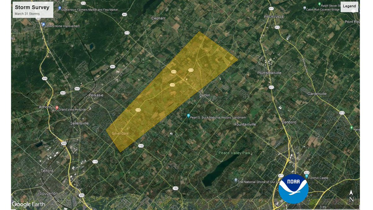
Tornado was confirmed in Bucks County:
https://6abc.com/tornado-bucks-county-bedminster-pa-dublind-tinicum-township/11699553/
-
1
-
1
-
-
I had a huge downpour just as I thought things were leaving. Calmer now.
-
Bucks again. Glad for them it was cancelled. Wasn’t too bad here. Rain, some thunder, and some wind.
-
6 minutes ago, JTA66 said:
I was wondering about the instability too. Looks like there was some clearing in central PA on the visible sat while we’re socked in.
But last summer we had that severe event that produced the tornadoes in lower Bucks with no sun that day. Just wondering if there are any similarities to today.
I don’t think so (a tornado watch would be out), but I am no expert on this.
-
Any tornado threat expected? Or mostly just chance of strong storms?
-
1 minute ago, RedSky said:
A lil annoyed. Firstly today was supposed to be a sunny day from forecasts all week, it's overcast.
Secondly, it's now raining
Yes, I prefer some nice dry spring days in the 60s.
-
1
-
-
Had downpours, some wind, lightning and thunder. But fortunately none of the isolated tornado risk talked about, or hail.
-
1 hour ago, snowman19 said:
It’s over Johnny, done, finished, stick a fork in it, give it up, fat lady has sung, let it go, game over, bring down the curtain, say goodnight and goodbye, adios….a former winter. We don’t live at northern New England’s latitude….
Well this time I’m not sure I can argue. It really may be over until at least November.. can’t rule out a few colder days though.
-
1
-
-
Heavy, wind driven snow in Royersford. Best scene I’ve had all winter.
-
27 minutes ago, Rockem_sockem_connection said:
I like summer. Get to take the boat out, enjoy the outdoors and soak in the sun. Beach days, green scenery. A lot of people like summer. In fact, it's actually the most popular season. I am sorry it is so tough on you.
I don’t like it because of the heat, humidity, severe storms, etc. But everyone is different. At least we’ll have baseball.
I’ll just enjoy the 2-4 inches coming down hard for a while tomorrow, if I even get that much.
-
1
-
-
Mostly all rain here. Another disappointment. If Saturday doesn’t work out, might as well stay mild.
-
1
-
-
54 minutes ago, Rockem_sockem_connection said:
None I don't think for this area just wondering if it could happen. One last chance at this.
Yes, it could happen. There’s supposed to be cold air available with the right track. Odds aren’t high, but could be a last chance.
-
7 minutes ago, Rockem_sockem_connection said:
Saturday 3-6?
Which model shows it?
July 2022
in New York City Metro
Posted
Yeah it has been a while with such a long stretch. And an eventual cooldown to the upper 80s will only be limited relief.