

Gravity Wave
-
Posts
1,165 -
Joined
-
Last visited
Content Type
Profiles
Blogs
Forums
American Weather
Media Demo
Store
Gallery
Everything posted by Gravity Wave
-
Absolutely, and the GFS has decisively outperformed the Euro this winter. My guess is the Euro is playing its catchup game where it gradually caves to the GFS as with the inland runner 2 weeks ago.
-
Meh. Not impressive for the city compared to GFS and CMC. Beautiful setup but the surface low is still too far east. That being said, it was a big improvement from 0z and we're just a tick away from an amazing outcome.
-
The timing of the phase and the axis tilt is really key. Had the latter happened a tad earlier on the GFS we go from MECS to HECS.
-
8-10 in the city on the EPS mean, 10-15 on LI. Needless to say, extremely impressive considering the lead time and the fact that this is an ensemble mean rather than an OP run.
-
 Plenty of a margin of safety for us if this NW trend continues. With this airmass and the HP where it is, we should stay all snow unless the low passes almost overhead. Plus it looks like the kicker might prevent the storm from getting too far north.
 -
Light snow on the east side of Manhattan. Many sidewalks have been made slippery by the excessive salt that has been thrown down...
-
So far this winter is reminding me of 2018-19, where one big storm slid just south of us due to bad luck early on and we came up with snake eyes the rest of the season. I think the highlight of the year was getting 2 inches of slush in late February.
-
OBS and nowcast 9PM tonight-8A Wednesday for a general 2-5" rain, isolated 8" possible. 40-60 kt damaging wind likely Tuesday-early Wednesday. Focus for damaging wind and heaviest rain is the I95 corridor to the coasts. Power outages esp CT LI.
Gravity Wave replied to wdrag's topic in New York City Metro
Let's get a repeat of this in exactly two months, thanks.- 228 replies
-
- 2
-

-

-
- heavy rain
- flash flooding
- (and 2 more)
-
Well in the NYC area, the further you are from Midtown Manhattan, the more snow you get in March. The boundary temps play a huge role in March since the sun angle is so much worse. March 2018 is a great example. Manhattan got 6-8" accumulation from the last storm that month, while Suffolk got 18"+
-
I'd be OK with no 90s in October ever again, thanks.
-
This is interesting. Has there been any research on tornado conditions in the Great Plains (i.e. the classic 'Tornado Alley')? That study indicates that the plains have been experiencing fewer tornadoes relative to the South and Midwest but nothing about the raw numbers of tornadoes in that region. This obviously isn't scientific but growing up almost every major outbreak seemed to be in the plains and over the past decade it feels like there's been more diversity in terms of tornado distribution. If there are fewer tornadoes in the Plains, what are some possible explanations?
-
My friends have said this as well, it's a big problem. The issue with Flash Flood Warnings (vs T-Storm, tornado, and winter storm warnings) is that most people who get them are at minimal risk of actually being directly impacted by the flooding since they're not in low-lying or susceptible areas, and unless you're familiar with flooding patterns in your area then you're not going to know what your personal risk actually is. If you live in an area that isn't susceptible to flooding you might never experience a FFW that verifies for you personally, and a layperson might then draw the conclusion that FFWs aren't much to worry about. This could lead to them venturing out and getting caught in a much more dangerous location during a rain event because they don't realize that the minimal risk their own neighborhood might be at isn't applicable to other areas.
-
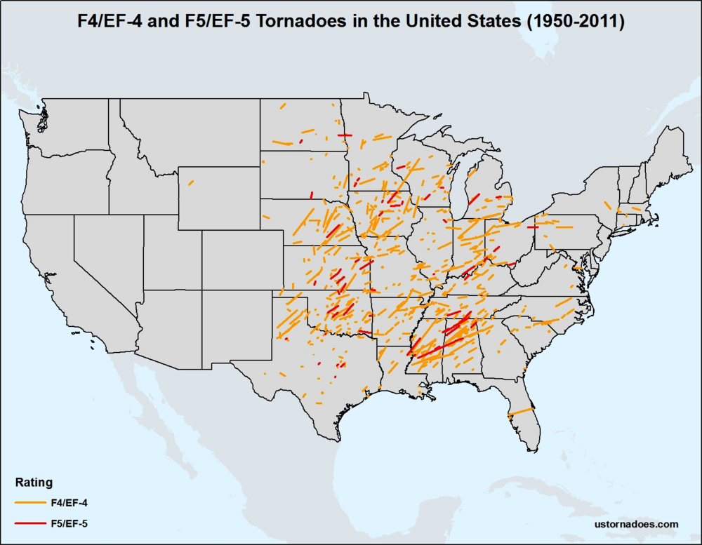
Either way, it was a hugely anomalous event. The only EF5 tornado ever recorded in the Northeast was the 1985 Wheatland - Hermitage tornado in far western PA. No EF-4 has ever been recorded in the vicinity of Philadelphia.
-
Large number of people stuck at the US Open it seems. Not in danger there but they might not get out tonight.
-
Lots of sirens here.
-
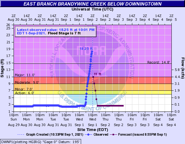
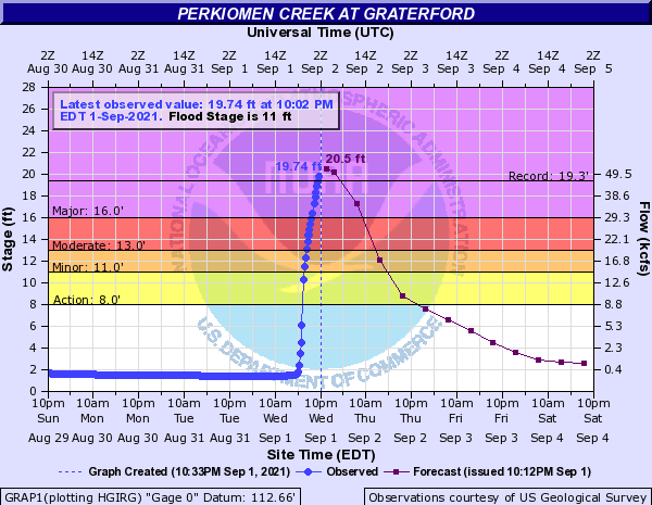
Historic flooding in SEPA, still pouring there:
-
Thinking ahead to January when we'll be begging for 0.5" of QPF from a storm.
-
Ground is completely saturated, water has nowhere else to go.
-
Labor Day 1998 and the May 31 - June 2 dual outbreaks earlier that year largely avoided the Philly area apart from some straight line winds from the edge of the derecho. IDK about 1989.
-
Then there's this, the forward speed is extremely impressive.
-
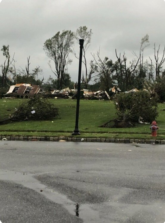
Wild damage photos from the Philly area. EF-4 rating seems possible based on this. Look at the uprooted bush in the foreground!
-
Dumping here, water is pouring off of my upstairs neighbor's balcony, running down the underside to the top of my living room window, and dripping onto my interior windowsill.


