Gravity Wave
-
Posts
1,165 -
Joined
-
Last visited
Content Type
Profiles
Blogs
Forums
American Weather
Media Demo
Store
Gallery
Everything posted by Gravity Wave
-

October 2019 General Discussions & Observations Thread
Gravity Wave replied to Rtd208's topic in New York City Metro
I think the all time record low temp for the lower 48 in October was set at Peter Sinks, Utah yesterday (-35!!!), breaking the record from 1917. It might get broken again tomorrow morning too. -
October 2019 General Discussions & Observations Thread
Gravity Wave replied to Rtd208's topic in New York City Metro
Ignoring the low skill areas, this would imply that the CFS sees a +PNA, correct? Or do the higher anomalies in Alaska indicate that the ridge will be too far west? -
October 2019 General Discussions & Observations Thread
Gravity Wave replied to Rtd208's topic in New York City Metro
The stalled patterns this decade are really something. Imagine if the next stuck pattern is a Midwest trough to go with our WAR. -
October 2019 General Discussions & Observations Thread
Gravity Wave replied to Rtd208's topic in New York City Metro
A more west-based version of 2014-15 wouldn't be that bad. The trough that year was too far east and so the Mid Atlantic got fringed repeatedly. -
October 2019 General Discussions & Observations Thread
Gravity Wave replied to Rtd208's topic in New York City Metro
Great coup by the NAM but the failure here by the other models is concerning. -
October 2019 General Discussions & Observations Thread
Gravity Wave replied to Rtd208's topic in New York City Metro
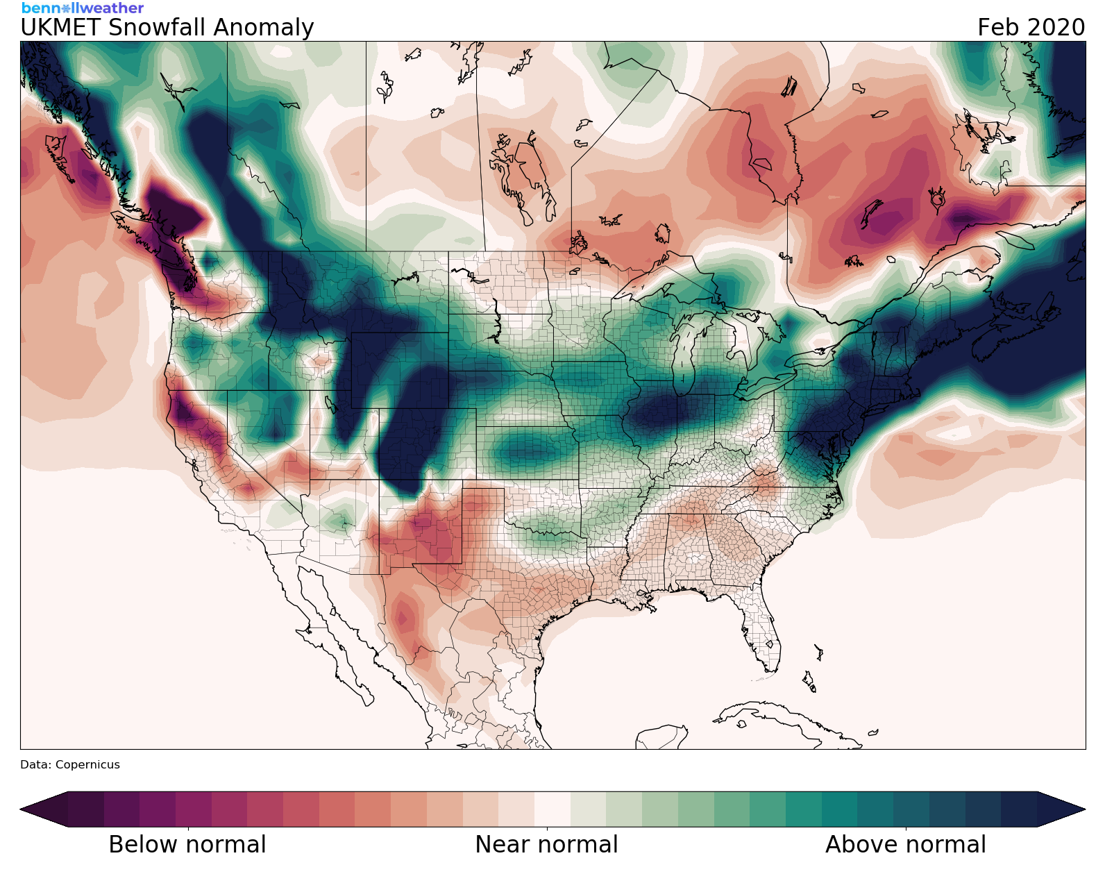
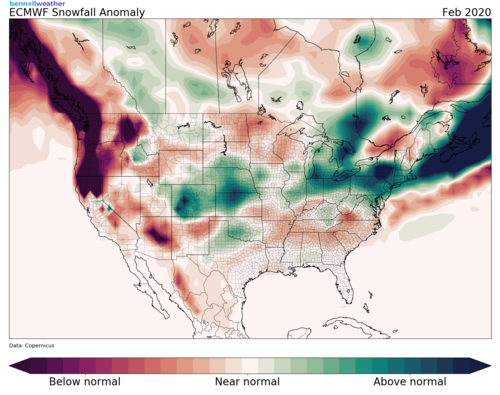
New Euro and UKMET seasonal snowfall outlooks are out. Long story short: December is a disaster, January is below average, and February is great. I don't trust these at all but they fact that both are in broad agreement is somewhat interesting. https://www.bennollweather.com/ukmet https://bennollweather.com/ecmwf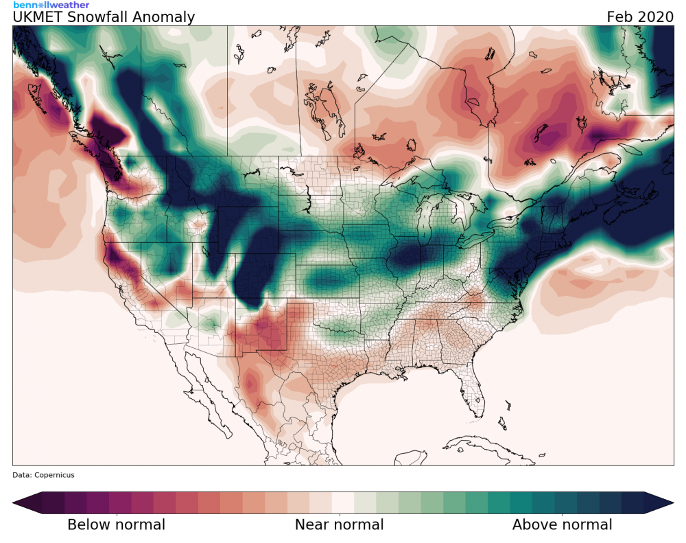
-
October 2019 General Discussions & Observations Thread
Gravity Wave replied to Rtd208's topic in New York City Metro
That developing system in the Gulf looks like it's going to rob us of our last chance of hitting 80 this year. If you believe the 12z GFS there aren't even any 70s on the horizon. -
October 2019 General Discussions & Observations Thread
Gravity Wave replied to Rtd208's topic in New York City Metro
The NAM is wetter than the HRRR but it seems to better reflect the radar so I'd lean towards it. -
October 2019 General Discussions & Observations Thread
Gravity Wave replied to Rtd208's topic in New York City Metro
Definitely a nowcasting situation. Good thing it's not winter! -
October 2019 General Discussions & Observations Thread
Gravity Wave replied to Rtd208's topic in New York City Metro
Euro is the clear outlier on the rain front, everything else is widespread 1.5-2"+. -
October 2019 General Discussions & Observations Thread
Gravity Wave replied to Rtd208's topic in New York City Metro
Definitely more rain than I expected here. There was a nice gust as I walked into work but the winds have generally been tame. -
October 2019 General Discussions & Observations Thread
Gravity Wave replied to Rtd208's topic in New York City Metro
Man if this was in January we'd be going crazy with these massive shifts inside 100 hours. -
October 2019 General Discussions & Observations Thread
Gravity Wave replied to Rtd208's topic in New York City Metro
It was cruel, and it only got worse when our perfect pattern arrived just in time to ruin the spring. -
October 2019 General Discussions & Observations Thread
Gravity Wave replied to Rtd208's topic in New York City Metro
Loving the cool temps today. As for this winter, I don't envy those who are putting forecasts out. The tangle of factors and the consistent failures of long-range modeling make it dangerously close to a waste of time, imo. If we get to Thanksgiving and the Euro Weeklies are showing a massive ridge for New Years then I might start to get excited for a big winter. -
October 2019 General Discussions & Observations Thread
Gravity Wave replied to Rtd208's topic in New York City Metro
The front has reached POU. https://w1.weather.gov/data/obhistory/KPOU.html -
October 2019 General Discussions & Observations Thread
Gravity Wave replied to Rtd208's topic in New York City Metro
Interesting. My parents in Allentown say they rarely see Stinkbugs anymore, which is noteworthy since the first one of those reported in the US was found there in 1998. -
September 2019 General Discussions & Observations Thread
Gravity Wave replied to Rtd208's topic in New York City Metro
I'm not seeing 90s on the 12z GFS, at least for the metro and points N&W. Saturday, Wednesday and Thursday look like the peak heat days, but even then it's mid 80s, not 90s. Legacy GFS and CMC are the same except they cut the heat off 1 day earlier. Am I missing something? -
September 2019 General Discussions & Observations Thread
Gravity Wave replied to Rtd208's topic in New York City Metro
Looks like it just manages to escape to the east at 216 as the ridge shift/breaks down but obviously the general idea from 0z is still there. -
September 2019 General Discussions & Observations Thread
Gravity Wave replied to Rtd208's topic in New York City Metro
Don't look now but here comes the Euro.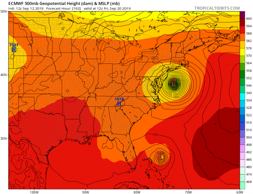
-
September 2019 General Discussions & Observations Thread
Gravity Wave replied to Rtd208's topic in New York City Metro
Hard to believe that there wasn't a stretch of that last fall. I guess it was more the extreme dews than 80+ temps. -
September 2019 General Discussions & Observations Thread
Gravity Wave replied to Rtd208's topic in New York City Metro
Yeah that's the weekend I'm talking about. I noticed the GFS last night had a Floyd redux for that Sunday and the 12z is showing a massive cane on a Dorian-like track (for our area, not further south). -
September 2019 General Discussions & Observations Thread
Gravity Wave replied to Rtd208's topic in New York City Metro
Ugh. I'm out of town next weekend with a flight back to LGA Sunday afternoon. Last thing I need is to be trapped in Pittsburgh in the midst of my lateral interviewing. -
September 2019 General Discussions & Observations Thread
Gravity Wave replied to Rtd208's topic in New York City Metro
Yup, there's a train of waves coming from Africa right now and the pattern seems favorable for a coastal track. -
September 2019 General Discussions & Observations Thread
Gravity Wave replied to Rtd208's topic in New York City Metro
Fun weekend coming up?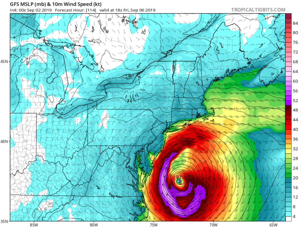
-
August 2019 General Discussions & Observations Thread
Gravity Wave replied to bluewave's topic in New York City Metro
I'm fine with a little more heat before the end of the summer as long as we don't have another July in September situation next month. Fortunately that looks pretty unlikely.