Cashtown_Coop
-
Posts
3,380 -
Joined
-
Last visited
Content Type
Profiles
Blogs
Forums
American Weather
Media Demo
Store
Gallery
Everything posted by Cashtown_Coop
-
Central PA - Winter 2021/2022
Cashtown_Coop replied to Bubbler86's topic in Upstate New York/Pennsylvania
Fascinating event! My feeling is I see no rain here. Snow to some sort of mix to dry slot. I could see a longer period of sleet possible. -
Central PA - Winter 2021/2022
Cashtown_Coop replied to Bubbler86's topic in Upstate New York/Pennsylvania
16/11. Yeah. Rather crazy. It doesn’t feel like a mix storm approaching. -
Central PA - Winter 2021/2022
Cashtown_Coop replied to Bubbler86's topic in Upstate New York/Pennsylvania
Bub how are rates with that band -
Central PA - Winter 2021/2022
Cashtown_Coop replied to Bubbler86's topic in Upstate New York/Pennsylvania
We might as well ride Frederick snd Washington warnings with this one. 4-7 with ice on top -
Central PA - Winter 2021/2022
Cashtown_Coop replied to Bubbler86's topic in Upstate New York/Pennsylvania
Radar is building. Give it another 30 -
Central PA - Winter 2021/2022
Cashtown_Coop replied to Bubbler86's topic in Upstate New York/Pennsylvania
17/9 light snow -
Central PA - Winter 2021/2022
Cashtown_Coop replied to Bubbler86's topic in Upstate New York/Pennsylvania
I think the radar looks good. 3 start time still looking good 16/7. NE winds around 5 -
Central PA - Winter 2021/2022
Cashtown_Coop replied to Bubbler86's topic in Upstate New York/Pennsylvania
That’s the thing. Another bump in amounts would turn the purples into pinks. Wouldn’t surprise me to see warnings with afternoon update -
Central PA - Winter 2021/2022
Cashtown_Coop replied to Bubbler86's topic in Upstate New York/Pennsylvania
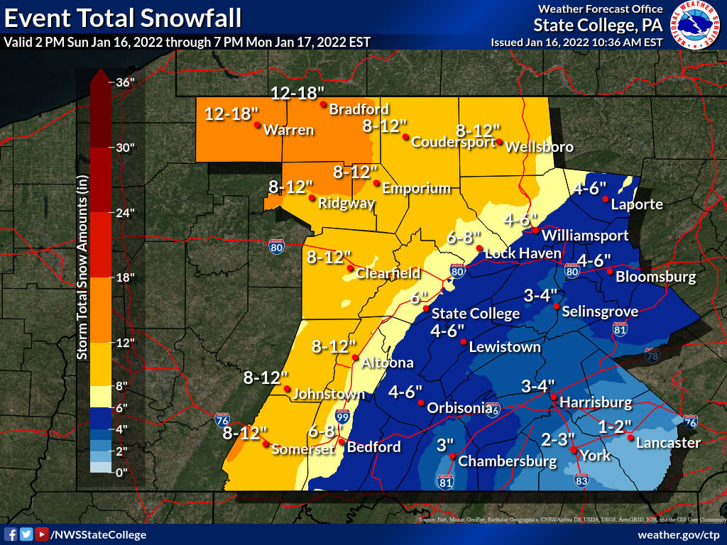
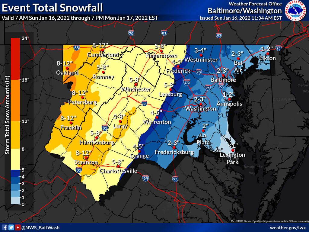
Here’s LWX discussion on why raising their snow totals. I performed a cursory analysis of current conditions this morning and I found that temps are running a few degrees cooler than forecast with dewpoints in the single digits. Up stream observations in NC and southern VA suggests that snow is over performing. I have adjusted my snow ratios this morning to account for the well below freezing layer ahead of the precipitation which should allow for higher snow rates. Initial onset of precipitation is on track this morning and snow should fluffy to start before switching over to wet snow as the layer starts to warm and transitions over to a wintry mix for most areas along and east of I-81. I will continue to monitor current conditions to see if I need to up snow totals. It wouldn`t surprise me if we get higher snow totals further eastward than expected due to extremely cool air mass ahead of this system. -
Central PA - Winter 2021/2022
Cashtown_Coop replied to Bubbler86's topic in Upstate New York/Pennsylvania
someone is going to bust.

-
Central PA - Winter 2021/2022
Cashtown_Coop replied to Bubbler86's topic in Upstate New York/Pennsylvania
15/4 @ 12:00 give me 1” qpf and I’ll roll the dice on precip type -
Central PA - Winter 2021/2022
Cashtown_Coop replied to Bubbler86's topic in Upstate New York/Pennsylvania
Its nice to see the dews staying low and not following the temp up. I’m up to 11 but dew is only 2 -
Central PA - Winter 2021/2022
Cashtown_Coop replied to Bubbler86's topic in Upstate New York/Pennsylvania
Not sure if it was brought up yet but CTP added more counties to warnings including Mag. Warning also stats 50mph gust Really couldn’t ask for a better scenario with clear skies last night and our lowest temps of the season with clouds pushing in now to lock the cold in. -
Central PA - Winter 2021/2022
Cashtown_Coop replied to Bubbler86's topic in Upstate New York/Pennsylvania
Should be a good eve for many as the snow is falling and Steelers are kicking KC butts -
Central PA - Winter 2021/2022
Cashtown_Coop replied to Bubbler86's topic in Upstate New York/Pennsylvania
9/1 after a low of 4 looks like hrrr gets me 3-4 hours of sleet -
Central PA - Winter 2021/2022
Cashtown_Coop replied to Bubbler86's topic in Upstate New York/Pennsylvania
978 low (28.88in) ne pa. Going to be some low pressure -
Central PA - Winter 2021/2022
Cashtown_Coop replied to Bubbler86's topic in Upstate New York/Pennsylvania
I get the eye this run -
Central PA - Winter 2021/2022
Cashtown_Coop replied to Bubbler86's topic in Upstate New York/Pennsylvania
Lots of green at 30 -
Central PA - Winter 2021/2022
Cashtown_Coop replied to Bubbler86's topic in Upstate New York/Pennsylvania
Same -
Central PA - Winter 2021/2022
Cashtown_Coop replied to Bubbler86's topic in Upstate New York/Pennsylvania
Warmest panel on Euro -
Central PA - Winter 2021/2022
Cashtown_Coop replied to Bubbler86's topic in Upstate New York/Pennsylvania
Euro holding steady 10 to 1 below -
Central PA - Winter 2021/2022
Cashtown_Coop replied to Bubbler86's topic in Upstate New York/Pennsylvania
It’s a slow mover -
Central PA - Winter 2021/2022
Cashtown_Coop replied to Bubbler86's topic in Upstate New York/Pennsylvania
@MAG5035 Blair and Adams share the same advisory -
Central PA - Winter 2021/2022
Cashtown_Coop replied to Bubbler86's topic in Upstate New York/Pennsylvania
Confidence level -
Central PA - Winter 2021/2022
Cashtown_Coop replied to Bubbler86's topic in Upstate New York/Pennsylvania
Looks like nice thump to dry slot with little ice