Chicago WX
-
Posts
18,333 -
Joined
Content Type
Profiles
Blogs
Forums
American Weather
Media Demo
Store
Gallery
Everything posted by Chicago WX
-
12z UKie still farther southeast and weaker. Uncle not yet drunk.
-
Not sure if that hurts or helps the NAM. Terrible model really.
-

Winter 2024-25 Medium/Long Range Discussion
Chicago WX replied to michsnowfreak's topic in Lakes/Ohio Valley
Canadian and ICON, what could go wrong? Again, this is *weenie* total for both systems.
-
Winter 2024-25 Medium/Long Range Discussion
Chicago WX replied to michsnowfreak's topic in Lakes/Ohio Valley
Not even sure this is worth posting, but one can always dream. The 12z ICON really goes to town across E IA, S WI, N IL, thru MI with the weekend system. This would be the *weenie* totals from both systems this week.
-
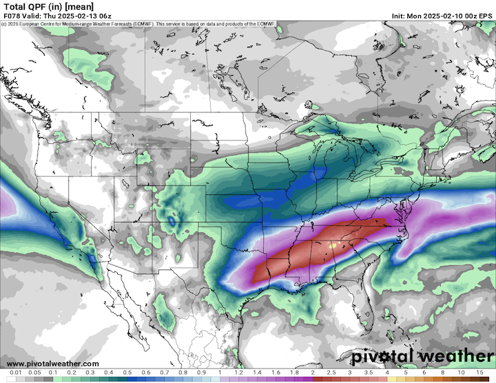
RGEM pretty much the same as its 6z run. Shaved a little off the northern fringes, tightened the SE fringes a bit, and back to a thumb jackpot from the 0z run. 6z EPS was essentially the same, but cut back on total QPF a bit in N IL. Chicago still 0.50"-ish, but farther southwest there was a bit of a decrease.
-
I would agree. 18 hours out from the storm, the NAM will probably have a run where it takes it off the Delaware coast. Well maybe not, but you get my drift.
-
NAM is a freight train. 12z gets a little light snow up to MSP with this run. I've got like 15 miles left and its lights out. 12z 3km NAM not nearly as amped though.
-
Yeah, that's good. I didn't see it when I made that post. Was referring to the GFS, RGEM, etc. Though I guess I also kinda lied because looking at the 6z ICON and UK, they both went south/weaker. JV models though.
-
Winter 2024-25 Medium/Long Range Discussion
Chicago WX replied to michsnowfreak's topic in Lakes/Ohio Valley
6z GEFS total run snowfall mean is up to 18.0" over downtown Chicago. Pretty large area of 6"+ really. Hopefully everyone gets a taste in the coming 2 weeks.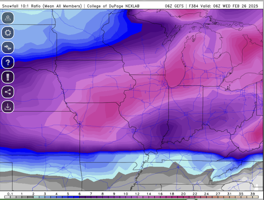
-
Pretty much everything at 6z ticked northwest. GFS closer to everyone else now. 6z NAM has the left turn blinker stuck in the on position, doing 95 mph down the Kennedy. But, nice to see an overall uptick in QPF. Just need to hold it, or get better, for 2 more days.
-
0z EPS likes Chicago.
-
Oz GGEM with a good hit. But it was definitely a step northwest, as much more of Iowa gets into the good snows.
-
GFS not backing down from whatever its doing.
-
Well, true. Think I almost jack potted in that disaster. Alas, I still like where Hawkeye, cyclone, etc sit right now on the modeling. But, still a bit of time to go to figure things out.
-
Who cares what the GFS shows. At this point, you guys are pretty much locked in. Enjoy.
-
0z RGEM looks fantastic though.
-
0z NAM looks pretty close to the 18z Euro. Shades of the past of the old EE rule? These days though, the NAM is worthless and the Euro is shaky at times. But, can't ignore the consistent moves NW by the Euro. If I was a betting man, I'd still side with it versus the other models. Iowa, N 1/4 IL, S 1/2 WI on east thru MI looking good right now.
-
18z RGEM was really nice. Seems the canadian suite are on the "stronger" train at the moment.
-
12z GEFS are better (wetter) than the OP. Good runs from the 12z EC, GGEM, and UK. Still think its a 3-5/4-6" system for most, but probably some higher lollipops in spots too. Think this will be a nice kick off to a fun upcoming pattern.
-
Winter 2024-25 Medium/Long Range Discussion
Chicago WX replied to michsnowfreak's topic in Lakes/Ohio Valley
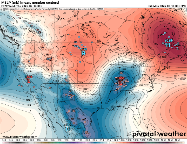
Nah, north of your line is in play too. Just loop the ensembles. GEFS, EPS, etc. It's a pretty good parade of systems coming through our region every 3-4-5 days. Just taking the 12z EPS through 9/10 days: it's this coming Wednesday, next weekend, and then next Tuesday/Wednesday. Details TBD, but I think quite a few us are in play for good snowfall in the next couple of weeks. Just takes one to phase in a piece or good chunk of the PV, and it's boom. No guarantees on that of course, but it's not improbable. Next weekend on the 12z EPS. Pretty good agreement. Granted we would like the mean farther northwest a bit, but there are left leaners.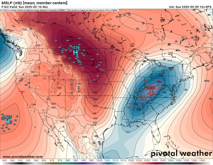
-
First real attempt by the NAM, and it's at least not taking it to Fargo. For real though, looks pretty similar to other models at this point. Kind of gives me a 12/8/2005 vibe with this system. Quick moving, but could rip pretty good for 3-5 hours outside a general 10-12 hour snow.
-
Winter 2024-25 Medium/Long Range Discussion
Chicago WX replied to michsnowfreak's topic in Lakes/Ohio Valley
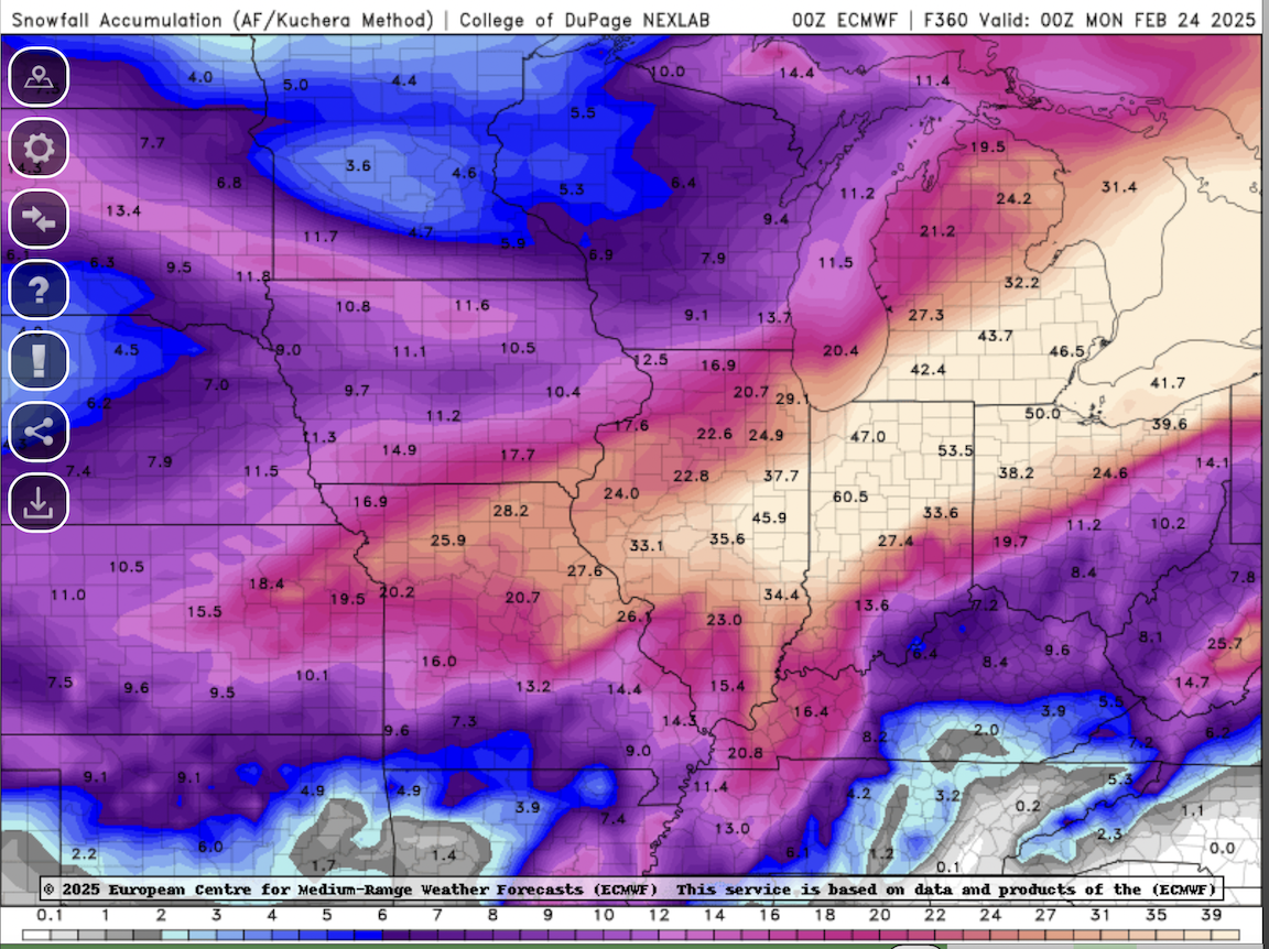
This is like hitting black jack 7 hands in a row. Hovering the cursor, there's a 61" showing up in and around the LAF.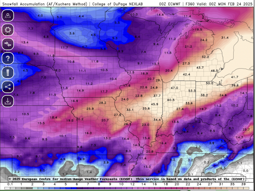
-
Long time no see. Pretty good agreement at this point amongst the op models/ensembles for a 3-5/4-6 type system. Maybe/hopefully we can get it to juice up a bit as it gets closer. I think the next weekend deal has a taller ceiling than this first storm. And then the EPS has another potential 4-5 days after that one. Best chance the region has had for a really good stretch of snows since Feb 2022. Hope it all works out.
-
My dogs love it. -3 right now. Winds ripping. Snowing. And they’re laying in the backyard in the snow. Have to beg them to come in.
-
The 5.8" is my report. Combination of the morning and overnight snowfall. 7.5" in Bourbonnais seems a bit high, but like vortex said, they're usually conservative. Most snowfall observers around here haven't the slightest clue what they're doing. Anyways, work was a beach today. Westside of IKK had 4-5 foot drifts. Some houses entirely surrounded by those drifts. Quite a challenge for me. And wicked conditions tonight with the snow, wind gusts close to 40 mph, and single digit temps. Arctic fun.