franklin NCwx
-
Posts
8,922 -
Joined
-
Last visited
Content Type
Profiles
Blogs
Forums
American Weather
Media Demo
Store
Gallery
Everything posted by franklin NCwx
-
2019/2020 Mountains and Foothills Fall/Winter Thread.
franklin NCwx replied to Tyler Penland's topic in Southeastern States
We got right at a foot here. That was the weekend my wife and I stayed at biltmore. They had about the same. -
2019/2020 Mountains and Foothills Fall/Winter Thread.
franklin NCwx replied to Tyler Penland's topic in Southeastern States
Most areas received 10-12" in that storm -
We also have a ++++AO and +++nao. I wouldn't be surprised to see this be more expansive and further north.
-
Southeast Sanitarium - A Place to Vent
franklin NCwx replied to Jonathan's topic in Southeastern States
I'll stay at the house and do just as well. -
2019/2020 Mountains and Foothills Fall/Winter Thread.
franklin NCwx replied to Tyler Penland's topic in Southeastern States
Yeah, Bryson is only about 1500' -
2019/2020 Mountains and Foothills Fall/Winter Thread.
franklin NCwx replied to Tyler Penland's topic in Southeastern States
Gfs shows how we can score in this crappy pattern. After a cutter early next week it brings up a wave along the front. This happens at the same time it builds in a 1046mb high in the northern plains. This could easily trend north or get squashed. Maybe we get lucky again. -
Gfs was on the last event from 8 days out.
-
February/March 2020 Winter's Last Chance Thread
franklin NCwx replied to John1122's topic in Tennessee Valley
Hopefully we can get a modest west based nao. We had that in December 2010 and the first half of January 11. In about a 40 day window that winter Franklin got over 30" with a -pna. -
February/March 2020 Winter's Last Chance Thread
franklin NCwx replied to John1122's topic in Tennessee Valley
If we could just get some blocking for March I think we can score a few events. Without any blocking most systems will cut. -
2019/2020 Mountains and Foothills Fall/Winter Thread.
franklin NCwx replied to Tyler Penland's topic in Southeastern States
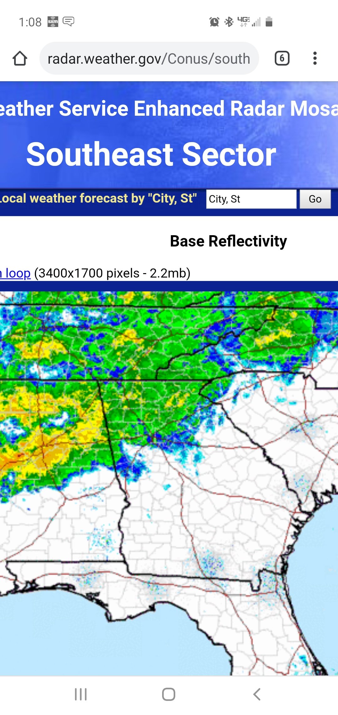
This radar image sums up how well the southern mtns block the moisture from reaching the French broad valley.
-
TN valley heavy rain/flooding week of whenever
franklin NCwx replied to janetjanet998's topic in Tennessee Valley
Same here. This wasn't supposed to start until late afternoon here. Started raining steady at 7 am. -
Yeah, for several of the ga and sc posters that was close to their seasonal average. It's much better than 19 pages of ground temps, sun angle, wake county snow hole, and wrals forecast.
-
2019/2020 Mountains and Foothills Fall/Winter Thread.
franklin NCwx replied to Tyler Penland's topic in Southeastern States
From everything I have read all of the southern mtns in NC are classified as a rain forest. Same with the north GA mtns and oconee county in SC. Here is an average rainfall map that shows it fairly well.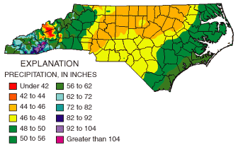
-
2019/2020 Mountains and Foothills Fall/Winter Thread.
franklin NCwx replied to Tyler Penland's topic in Southeastern States
We jumped up to 29 and still have some fog. Another flood watched issued for the southern mtns -
2019/2020 Mountains and Foothills Fall/Winter Thread.
franklin NCwx replied to Tyler Penland's topic in Southeastern States
Yeah, it's a nice area. We have been a few times. We have found a few we liked but are way overpriced. Hopefully we can find one before next winter. Cutters are great for that area! -
2019/2020 Mountains and Foothills Fall/Winter Thread.
franklin NCwx replied to Tyler Penland's topic in Southeastern States
Sweet! When housing prices drop we are gonna buy one in the Wisconsin dells. Its about an hour north of Madison. It's a big tourist area so I'll use it as a rental and write off our trips. Great hunting up there! Oh... and it snows more -
2019/2020 Mountains and Foothills Fall/Winter Thread.
franklin NCwx replied to Tyler Penland's topic in Southeastern States
Reading the lakes/Ohio valley thread it's been a bad year. Its picked up the last couple weeks with the cutters. But for the most part they're below normal -
2019/2020 Mountains and Foothills Fall/Winter Thread.
franklin NCwx replied to Tyler Penland's topic in Southeastern States
Right now Minneapolis has 35 inches on the season. They average 54. -
2019/2020 Mountains and Foothills Fall/Winter Thread.
franklin NCwx replied to Tyler Penland's topic in Southeastern States
It's been a terrible winter for everyone east of the Rockies. -
2019/2020 Mountains and Foothills Fall/Winter Thread.
franklin NCwx replied to Tyler Penland's topic in Southeastern States
I'm at 5" total. Very subpar year so far and all the rain makes it depressing! -
Yeah, there were several inches in Graham county with roads covered. They didn't put one out last week at all and Highlands and Cashiers were a mess.
-
They do this a lot. Or put out the warnings at 3 am on Saturday a few hours before the event. I have even seen them put out the advisories during an event.
-
2019/2020 Mountains and Foothills Fall/Winter Thread.
franklin NCwx replied to Tyler Penland's topic in Southeastern States
Down to flurries with about 3.5 on the ground. Puts me at 5 for the season. -
Good to see you and Burrell cashing in!
-
Good to see you north ga and upstate guys getting snow.