Amped
-
Posts
14,567 -
Joined
-
Last visited
Content Type
Profiles
Blogs
Forums
American Weather
Media Demo
Store
Gallery
Everything posted by Amped
-

2023 Mid-Atlantic Severe Wx Thread (General Discussion)
Amped replied to Kmlwx's topic in Mid Atlantic
The rotation sig went right over me, there wasn't much wind.- 2,785 replies
-
- 2
-

-
- severe
- thunderstorms
- (and 3 more)
-
Finally it's ripping now. I was hoping it would smell like hot maple syrup. Really disappointing.
-
Who needs an eclipse?
-
Many people out and about in Time Square https://www.earthcam.com/cams/newyork/timessquare/?cam=tsrobo1
-
Oh no, not grass!!!!
-
WPAC, Indian Ocean, and Southern Hemisphere Tropical Cyclones
Amped replied to 1900hurricane's topic in Tropical Headquarters
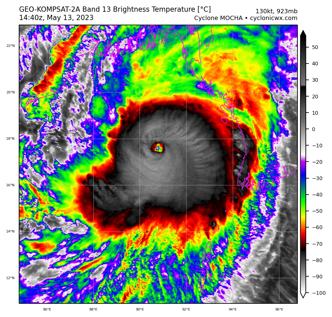
Latest IR eye temp on the ADT is +20C and still warming. 903MB 155kt is the intensity estimate from the advisory. -
WPAC, Indian Ocean, and Southern Hemisphere Tropical Cyclones
Amped replied to 1900hurricane's topic in Tropical Headquarters
Now has a very similar appearance to Dorian Edit: Didn't even realize this was already posted. -
WPAC, Indian Ocean, and Southern Hemisphere Tropical Cyclones
Amped replied to 1900hurricane's topic in Tropical Headquarters
You can see the intensity roller coaster from the past 48hrs. 140kts to 90kts, now back to 140kts and still rising.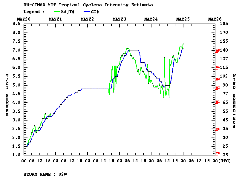
-
WPAC, Indian Ocean, and Southern Hemisphere Tropical Cyclones
Amped replied to 1900hurricane's topic in Tropical Headquarters
Rather substantial weakening and the track shifted well north of the island. Almost safe to say it's going to be a bust. -
WPAC, Indian Ocean, and Southern Hemisphere Tropical Cyclones
Amped replied to 1900hurricane's topic in Tropical Headquarters
Looked like a dry air intrusion for a while. Now it clearly has the appearance of an ERC. -
WPAC, Indian Ocean, and Southern Hemisphere Tropical Cyclones
Amped replied to 1900hurricane's topic in Tropical Headquarters
With all the advances in AI, a preschooler could still find the center of a TC better than ADT.
-
WPAC, Indian Ocean, and Southern Hemisphere Tropical Cyclones
Amped replied to 1900hurricane's topic in Tropical Headquarters

-
Before landfall but not at landfall. Kind of makes sense since it was moving so slow and the strongest winds were on the back side of the storm. The core would have interacted with land for about 6 hrs before the strongest winds got onshore.
-
Just had another huge gust that woke me up.
-
It wouldn't be a windstorm without garbage blowing around
-
It's windier now than during the Tstorms
-
The HRDPS sometimes beats the American mesoscale models on convective setups in the northern half of the country. HRDPS was the only one to have the line this far southwest.
-
Yeah the cell on the MD/DE border looks like it's trying to produce something.
-
2023 Mid-Atlantic Severe Wx Thread (General Discussion)
Amped replied to Kmlwx's topic in Mid Atlantic
HRRR has one cell ahead of the line over Wilmington & SNJ. Watch out if that forms it will have some really good parameters.- 2,785 replies
-
- 1
-
-
- severe
- thunderstorms
- (and 3 more)
-
Hopefully the crapvection disrupts that thing before it gets to Bloomington.
-
Another cell wants to spin up in S TN between the other two. They're keeping the spacing well.
-
Doesn't do it justice, a lot of those will be EF2+
-
Taking almost the same track as the last one.
-
Another cell in eastern ARK looks like it's got a couplet forming. Edit E of Marvell Ark needs a warning
-
That one does not look like it's going away quickly. Possible long tracker.