HighStakes
-
Posts
4,385 -
Joined
-
Last visited
Content Type
Profiles
Blogs
Forums
American Weather
Media Demo
Store
Gallery
Everything posted by HighStakes
-
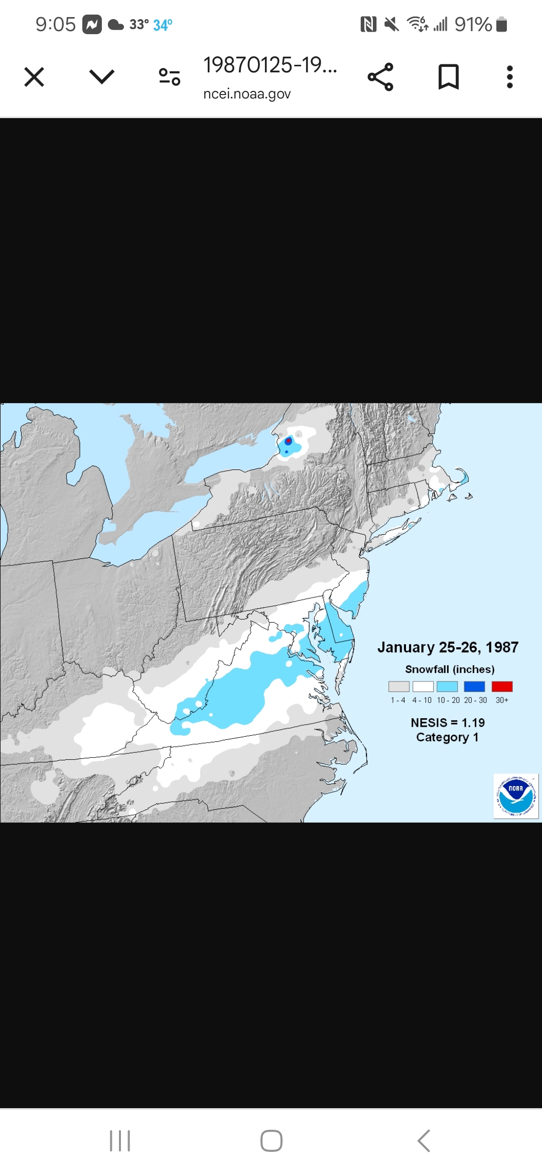
As of right now I see a lot of similarities to the 1/25-26/1987 NESIS storm. Very cold storm. I lived in Owings Mills then and we got 6. Probably was only around 4 up here where I am now. This upcoming storm looks to have a much broader precipitation field with much less chance for a sharp cutoff like in the 87 storm. Better upside for all involved with next week's storm
-
All I said was I'm guaranteeing you 6 inches of snow and a Wsw that verifies but I didn't say when. Lol.
-
Yeah! Definitely creepy
-
Heading out to dinner with the wife for late Valentine's Day right after 18z EURO. Much need 2 hour break from this madness. @North Balti Zen, @Maestrobjwa I'm guaranteeing both of you at least 6 inches a WSW that verifies.
-
2/15: 1.0 Total: 19.0
-
Still a long way to go. This run is fine. On a side note I guess this Stormy character is a troll?
-
There's does seem to be some added pressure on this storm delivering. The teleconnections on the EURO ensembles don't look so hot. Such a quick reversal on all the important indices starting around the 19th/20th. Didn't see that coming a week ago. Looked like we were going to be locked in through Mid-March. Not so much anymore.
-
Still plenty time to trend either way. Always a nail biter though. Still 96 hours from first flakes. There can be drastic changes even in the last 24 hours. Until Monday there will still be ebbs and flows.
-
Not sure what we got exactly. I was at indoor baseball practice and it turned to sleet and rain by the time practice ended but it looked like at least an inch.
-
As long as the EURO holds that's all that matters.
-
170 members browsing!
-
Snowing. Dusting. Another system so close to a nice 3-4 inch thump that isn't quite going to get there. It seems were losing these type of event as well.
-
Thickening clouds Wednesday after a morning low around 10. Then a high in the low 20's with snow breaking out in the afternoon. Knowing it's going to snow for the next 24 hours with 2ft. on the way. This is why we do this. We need to bring this one home.
-
Almost a 30 hour storm.
-
Yes!
-
Such an expensive heavy precipitation field. No sharp cutoff. One could argue with this evolution that those totals are underdone. Lol
-
I like how the precipitation field is vast and reaches far north and west from the center of the low.
-
This run is a 24 hour storm starting before 12z Wednesday. Runs like this make tracking fun yet exhausting.
-
That's a very amateur statement.
-
Can we get a stall to go a long with the yank? A long event would be welcomed. I would've thought with the sequence of storms we had every few days there would be more of a slowing.
-
GFS and Euro continue to be way different on the timing. GFS has snow starting Wednesday morning and EURO is almost 24 hours later.
-
Models certainly holding steady on the idea of an extremely cold storm. Never gets above 20 up here at any point. Quite impressive for a daytime storm later in February.
-
A little 1983ish with more modest totals. Very cold storm as depicted.
-
Where there's a WILL there's a way!
-
I guess once the weekend storm plays out then we should have a consensus by Sunday evening at least as far as the evolution for mid week.