josh_4184
-
Posts
1,207 -
Joined
-
Last visited
Content Type
Profiles
Blogs
Forums
American Weather
Media Demo
Store
Gallery
Everything posted by josh_4184
-

Upstate/Eastern New York-Into Winter!
josh_4184 replied to BuffaloWeather's topic in Upstate New York/Pennsylvania
Hey Matt , not sure where everyone went all LES guys are pretty much gone in the GL Sub. Your sub seems way more active especially pertaining to LES belts. -
Upstate/Eastern New York-Into Winter!
josh_4184 replied to BuffaloWeather's topic in Upstate New York/Pennsylvania
Not much action on my sub anymore been a away myself for a bit thought I would send out a pic of what's headed your way, been getting hammered the last few hours, about 5" so far still coming down.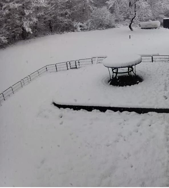
-
Back to Back Major Synoptic Snowstorms!
josh_4184 replied to BuffaloWeather's topic in Upstate New York/Pennsylvania
Yea my specific area is about 50-60" below for the year, NWS APX is showing: way below for Gaylord Proper, basically any snowbelts that normally rely on NW or WNW flow. This year ha been very odd in all my years I have seen such rare wind flows from the WSW, SW, or even ENE be the primarily direction. In the average year the most common winds are primarily out of the NW or WNW which is how my area gets hit but obviously there are exceptions and this year is certainly one of them. Even the UP is in similar situation with the possible exception of the Keweenaw. I cant ever remember a time where Chicago has had a deeper snowpack than my area, in average winters I normally see at least once a winter a 40" snowpack I think this year the deepest I got was to about 18". Not sure about the WNY belt members but I have been ready for spring since about Jan 1st.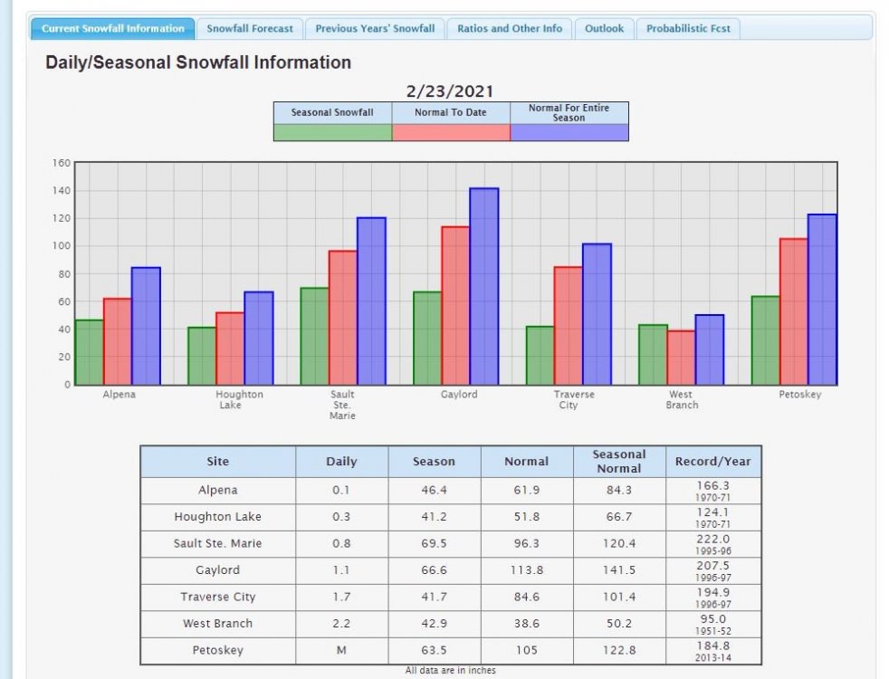
-
Yea I was thinking such a waste of a warm Lake Mi with the PV with this crappy 850 flow, had such potential if the winds weren't w or wsw like they have been the past 10 days. Now the lake is icing up so almost time to put a lid of a terrible LES season for almost all the normal heavy hit areas. My area has the potential to be 60-80" down on average snow for the year.
-
A lot of nice restaurants opened recently downtown now as well in Gaylord, not that you can actually dine again if you are into that as well. A couple nice micro breweries /etc.
-
Yes Nice Park, the trails are good although never been in the winter. Seeing the large Elk is pretty awesome. Not sure how deep the snow will be however I have about 15-17" OTG currently. Probably less over on that side of Gaylord area.
-
Ended with about 3-4 overnight nothing special. Whole event for a couple days was about 10" areas NW of me did better with more LES. Looks like downstate LES belts did pretty well too.
-
Picked up about 7" of synoptic Thursday night, only light LES throughout the day, strongest banding was towards my NW as I anticipated with the WSW/W flow earlier targeting Petoskey area towards Boyne down to Ellsworth. Now flow has switch to more of a WNW flow and been getting hit heavy the past hour or so, depending on how long it takes for the dry air to move in will depend on how much can pick up. If it it holds off until morning can see 6-8" more for my area..
-
Northern lower or UP? Gaylord will do well, the clown maps never model the heaviest snow for my area, it seems to always slam Mancelona, Bellaire, and EJ, however my area towards Elmira, down to just north of Kalkaska always have the most snog otg. With that being said the initial LES setup with be more west based or wsw which will favor Petoskey/Emmet county and towards Boyne area. If?? When the 850 flow changes more to a WNW or NW flow that's where my area cashes in. Granted we will still see 8-10" into early weekend, then antipirate another 3-4" each day maybe more depending on banding/flow not moving to much. Safe bet that most NWL Michigan will have a good snowpack in the next 2 weeks, exactly where the deepest hardest hit will as always depend on who gets under the heaviest banding which is always a guessing game. In UP I would say near Grand Marais toward Paradise or Keweenaw will get hit good.
-
GFS still pretty bullish for my area, painting 40-50" somewhere near me and upwards of 70" in the UP. Ready to put my new snow plow to work.
-
NWL: Lake Mich usually take a while to freeze compared to shallow Erie but to not have Green bay covered with ice this late in the season is pretty crazy. Areas downwind of Ontario are going to get hammered.
-
Lake Michigan still wide open for business very little ice if any pretty rare this time of year.
-
I think the whole idea was to have consistency for headlines for people wouldn't get confused, a lot of people travel don't even know what LES is let alone a warning. However it seems that NWS BUF hasn't fully adopted it and doesn't do any favors by picking which headline they use for LES depending on the forecaster it seems. With that being said GRR seems pretty bullish on the LES chances which is fairly rare it seems for them. A poster eelier was posting a previous AFD from them stating LES would be cut back due to riding. Today they say: --Lengthy cold snap, coldest yet this winter-- The cold Arctic air mass is expected to impact the Great Lakes Region through the end of next week. High temps will be mostly in the teens with lows in the single digits or below zero and wind chills often below zero. It`s been quite a while since we`ve had a lengthy stay of air this cold and winter has been fairly tranquil so far, so definitely a big change. Ice on area rivers and lakes will continue to grow... see hydro section below. --Snow piles up over the next week-- Westerly flow lake effect snows are likely to persist into Friday night and Saturday with additional accumulations near and west of 131. Then we get another Arctic front coming through on Saturday which may produce a widespread/areawide 1-2" snowfall, followed by additional lake effect yet again in wrn sections Saturday night. After that, the thing to watch will be a clipper system sliding through southern sections Sunday night and perhaps even another synoptic snow event for Monday night. Some locations over wrn Lwr MI could easily end up with two feet or more of new snow by this time next week.
-
I do find it interesting how much earlier NWS Buffalo hoists headlines then APX. Also it does seem odd how they use both Lake Effect Snow warnings and Winter Storm warnings for the same weather events:. Most of Michigan NWS's switched over 100 percent to Winter Weather and Storm warnings for all snow events synoptic or LES.
-
Yea for my area earlier in the season for LES it tends to be more moisture rich with ratios around 15-1, as winter progresses and the lakes cool and the colder air comes it the snow tends to be more powdering like talcum powder. Doesn't accumulate as well and is a biT*& to see when driving in stronger bands. Of course a lot of this depends on the how cold the 850s are, how much RH, and if the snow is in the cloud layer or pushed to the deck creating much smaller dendrites. With that being said I am looking forward to our best setup of the year for decent LES.
-
Agreed. Most LES accumulation never even comes close to snowpack depth. I average 150-175" a year and usually only for about 1/3 of winter do I 30"+ depth, my area usually runs between 12-24 average depth. With that being said, depending on 850 flow(NW or WNW for my area) and being able to lock in for a day or so I have seen 2-3' easily in my area over a couple day period now that doesn't mean I will have a 3' snow pack due to compression but it will still be fairly deep especially with the 10" of glacier I have now. When snowmobiling around my area it was not uncommon to find areas near my house of chest deep snow untouched especially in wind/sun protected areas With the lakes as wide open as they are for this time of year with the cold coming in it will pile up, but the extreme cold and small flake size will cut back accumulation.
-
Definitely liking prospects for LES for most GL Belts. Along with some additional synoptic initially with the system through Friday I can see areas easily cashing in 2-3+" in the next 10 days. Depending how cold it gets, I venture to say the following weekend will be the best snow conditions of the year for my area barring any synoptic miracles after the PV leaves. 2nd weekend of Feb was always my go to weekend for snowmobiling when I used to ride and should be a great weekend this year.
-
GFS been showing some life for the snow belts the past few runs, painting my area with 50"+ of snow, obviously not realistic but its at least showing something. Hopefully Feb is a decent makeup for Nov,Dec, and Jan.
-
Just got done plowing, 12-15" of fresh powder on top of the 7-8 I got the other day. Tyr to get some pics tomorrow if I have time.
-
Im over 50" for the year now, but a lot of that was from the two early synoptic storms we got.
-
Yea I saw that recently Kalamazoo hasn't even had 12" of snow yet I was pretty shocked I am originally from Jackson and 131 always had at least 70-80" a year of snow. Tis week my area has definitely ate through some of the deficit, probably picked up about 14" so far the past two days and still hitting pretty good when I left for work this morning. May get another 2-4" throughout the day.
-
Been that way up here until recently, about 45" under average for the year so far.
-
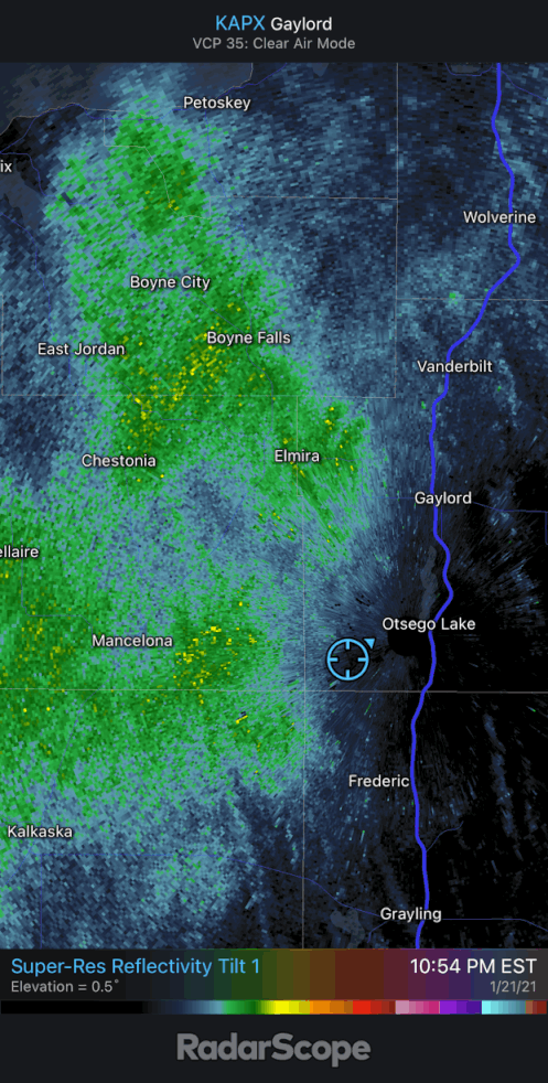
Really ripping now for the past couple hours, 1-2" per hour rates. If this keeps up will have 12-16"+ of LES by morning. Little surprised APX hasn't upgraded the surrounding areas to warnings. This is where using LES advisories and warnings are more suitable then using winter storm warnings etc. Still don't like that they dumped those headlines a few years back.

-
Picked up another 4" today, another 4-6 thru tomorrow. Definitely feels like winter up here.
-
Have about 13" OTG now, deepest of the season, starting to look like winter around here again for the LES Belts.