

Snowstorms
-
Posts
4,094 -
Joined
Content Type
Profiles
Blogs
Forums
American Weather
Media Demo
Store
Gallery
Posts posted by Snowstorms
-
-
4 hours ago, Terpeast said:
We did get the coldest first week of december in 14 years. All other first-week decembers colder than this one are between 2002 and 2010.
The first week of Dec 2008 was pretty cold too. So definitely been a long time since we've seen a cold start to December, so it's nice. Although, at least locally, 2010, 2008, and 2002 were more colder.
-
2 hours ago, michsnowfreak said:
Wow very nice. Just a dusting on the ground here. We have had 9 days this season with T - 1" on the ground but no more yet. Im waiting for those piles!
The Georgian Bay band was a little surprise. We don't see see lake effect bands extend that far south. Thanks to the snow cover, YYZ got down to 12 last night. Our coldest low so far.
Hoping we can both see something more widespread so we can have a piece of the pie together.
-
 1
1
-
-
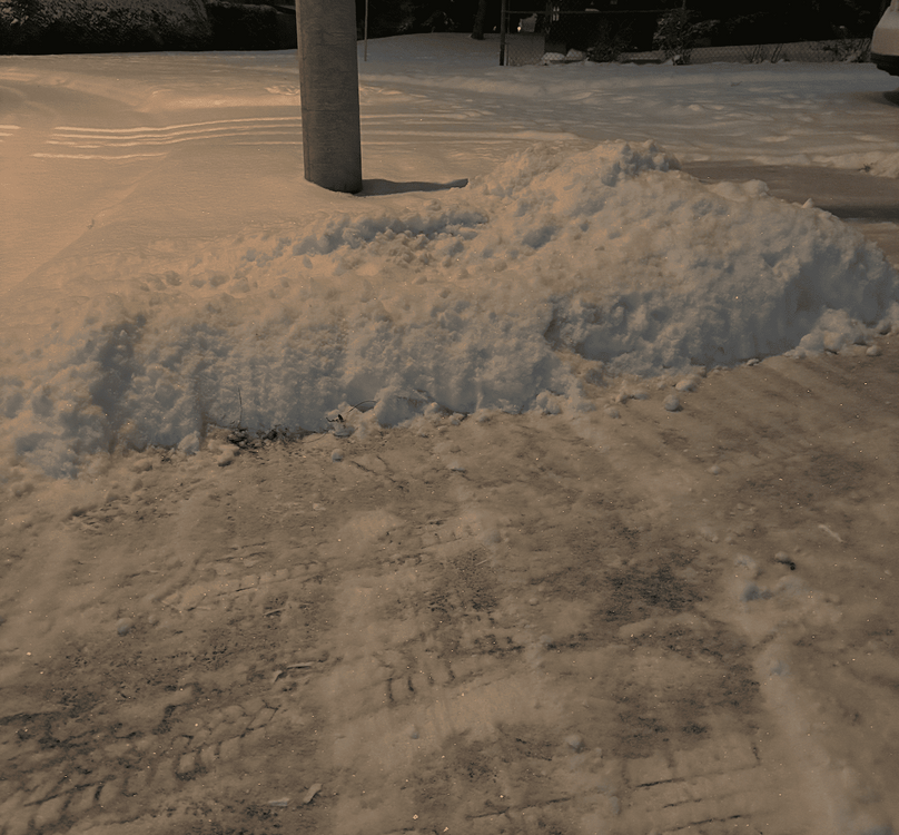
Looks like HRRR nailed the Georgian bay band. Measured 2.1" with the band today in Woodbridge, just north of Toronto. About 5" on the ground now.
Nice to see snow piles again on the edge of my driveway. Winter wonderland

-
3
-
-
14 hours ago, nwohweather said:
Good thing my meeting in Mississauga was moved. Might have gotten a bit dicey around London
London got slammed today with 20-30". Good thing it was moved. You would've gotten stuck.
-
2
-
-
Just measured 2.5" from this clipper. Looking like a winter wonderland. HRRR has been showing a strong LES band off Georgian Bay tomorrow that reaches into Toronto and possibly dropping up to 2" especially north of 401. We'll see if that pans out.
-
2
-
-
1 hour ago, cyclone77 said:
At least the cold northwest flow will bring mood flakes to those fortunate to be downwind of the GL.
Excited for my occasional 5 minute burst of heavy flurries.
-
On 11/26/2024 at 7:02 PM, IWXwx said:
At least Canada is cashing in, FWIW
Low of -27F tonight feeling like -42 with a high of -20F tomorrow in Regina, SK. Bone chilling cold and quite the pattern reversal from the record breaking warm start to Nov.
https://weather.gc.ca/en/location/index.html?coords=50.450,-104.617
-
2
-
-
4 hours ago, bluewave said:
You can see the blending of the influences in the emerging model trends for the start of December. The +AAM spike introduced the high latitude blocking on the Pacific side. But we still have a lingering La Niña influence with the jet trying to split the ridge near Alaska between the -WPO and +PNA. What may happen is that one of these jet disturbances is strong enough to cause a relaxation of the pattern mid to late December. But if this neutral ENSO state continues into January, then we could get follow up Pacific blocking at that time which would help to erode the -PDO.
New run ridge slight lower -EPO ridging stronger jet

Old run more consolidated block weaker jet

How is the most recent -PDO pattern (2019 - present) different than prior -PDO periods (i.e., 2005-2014 or 1960-1976) that featured more prominent cold winters? Perhaps the marine heatwave is having an effect on the PDO?
-
13 hours ago, bluewave said:
One thing to note for the first week of December is that the 850 mb temperature departures are forecast to be colder than the 2m since the Northern Hemisphere snow cover is still near record lows and will need some time to catch up.


Snow cover is building pretty fast across Western Canada with a few storms that have passed through the region this week and again into next week. After a record breaking warm start to November, things flipped pretty quickly out west. Currently 12 in Calgary. Only thing concerning is the lack of ice around Hudson Bay.
-
1
-
-
2 hours ago, Torchageddon said:
Been blessed not to have as much cloudiness as forecast, yesterday afternoon was fine with sun out and then this morning I got hours of sunny breaks with modest clouding up after noon. No rain ever came! The Thanksgiving prize was instead of -1C it only made it down to 3C.
For any Canadians left here, happy Thankgiving!
Happy Thanksgiving to you as well
")
If skies clear up tonight, YYZ will likely make it down to 2C (35F) as well.
-
1
-
-
4 hours ago, Stebo said:
Incredible rain yesterday for Toronto, Pearson broke their daily record that goes back to July 8th 2013, that was the day the 427 had catastrophic flooding. And it breaks the all time summer record.
Yeah it's been a crazy wet summer for us. I got stuck on the 427 yesterday because of the flooding. Though I attribute half the flooding due to poor infrastructure and a lack of improvements over the last few decades.
We are now sitting at 34.5" of precip for the year and already above our yearly average of 31.7".
-
2
-
-
Hoping to hit our 2nd 70 of the year tomorrow, if not, mid next week looks like a safe bet lol.
-
2
-
-
5 hours ago, michsnowfreak said:
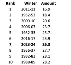
Where does this season rank in Torontos entire period of record?
7th least snowiest on record. Here's the top 10 going back to 1840. Note I used YYZ from 1955-onwards.
-
2
-
-
5 hours ago, mississaugasnow said:
@Snowstorms @michsnowfreak Even with that big push in late March YYZ is still at 6th least snowiest season on record at the airport. I don't know about you guys but to me thats going in the futile pile. 6th place has a cushion of about 2" before this winter would slip to 7th.
Not happening. Just an initial look at the models and upper air pattern would suggest winter is largely over for us. The storm this week was underwhelming and only produced snow further north and east. YYZ will likely finish at 26.3" for the season, well below our 44.5" average. This winter receives an F grade from me.
Hopefully this was our last sustained cold too, ready for some warmth and thunderstorms now.
-
@mississaugasnowWatching the Tues-Thurs storm closely right now. Still a few days out but with the lingering cold air from the high in Quebec, there could be the potential for a messy storm across the GTA. Potential is there for rain, ice pellets, and snow. Might be winter's grand finale.
-
1
-
-
On 3/21/2024 at 7:39 PM, michsnowfreak said:
So not as many as I recalled. Quite a few in the 3-5" range but only 2 officially 6+ post Mar 15th since 2000.
7.2"- Apr 5/6, 2009
7.3"- Mar 21/22, 2008
I had an 8" storm Mar 25/26, 2002 where DTW only had 4.7" (huge cutoff).
For us, the two most recent late winter storms would have to be (not including today):
Apr 3/4, 2016 - 5.5"
Mat 23, 2011 - 5.0"
Our climo supports more smaller events (<3") than bigger storms after mid March.
-
2
-
-
2 hours ago, mississaugasnow said:
@michsnowfreak. @SnowstormsTheres going to be some wild difference in snow totals across GTA
Pearson will end up middle ground. Looks like 6-10” east end. 4-6” Airport and 1-3” for my place and west end.
Hamilton and my place is now pretty much locked into seeing one of the worst winters snow wise ever.
Still up in the air with Pearson
I just measured 6.2" in my backyard. Great storm.
This storm will push YYZ ahead of 06-07 and 15-16, which would put it at 6th lowest ever.
If we used a combination of Toronto and North York (1840-present) then 2023-24 would be 4th lowest lol. Doesn't matter how we spin it, this winter was a monstrosity for all of us.
-
1
-
-
@mississaugasnowYYZ has somehow surpassed 09-10 and 52-53 and is now sitting at 4th least snowiest on record. Friday's storm could make the difference if we surpass 06-07 or not.
Won't change anything. This was winter was total horseshit. But glad we avoided a futility winter.
-
5 hours ago, 40/70 Benchmark said:
Here are the Modoki La Nina seasons that were preceded by active ACE years.
Maybe we will manage a bit more snowfall next year, assuming a high ACE (can it be less?), but should still be mild.
Possibly a bit cooler with the warmth centered to the south, as opposed to north...like this past year. But the winter will probably be better out west again.

2008-09 and 2011-12 were second year La Nina's preceded by much stronger La Nina's the year before. So I don't know if that matters from an analog perspective. 2016-17 hardly lasted for more than 5 months and only bottomed out at -0.7. 2016-17 could be an analog depending on the strength but that's far out anyways.
-
12 hours ago, bluewave said:
Yeah, there have been many comments on the forum how this -PDO La Niña background state has been so much warmer especially during the winters than older -PDO La Niña years before 15-16. I think the record SST warming near Japan is going hand in hand with the warming in the MJO 4-7 areas. So both those features tend to promote an Aleutian ridge near the Dateline and a ridge near the Eastern US. Notice how even with such a strong El Niño this winter there was still that ridge south of the Aleutians instead of the much stronger Aleutian low typical for strong El Niños.
Great post.
There's been a lot of comments about the warmth in the last couple of winters being driven by the -PDO but I don't think so. Just a quick glance at the SST maps can tell you how atypical the current -PDO looks despite a deeply negative anomaly. I believe the period between 1998-2014 was the last time we had a true -PDO phase and it was quite reflective in the Pacific ssts. And we experienced several cold winters in that period especially from 2007-2015. Maybe a strong La Nina may shift those anomalies and also drive down Pacific SST's especially off the coast of Japan and in the WPAC. The warm Atlantic and +AMO don't help us either.
A poleward Aleutian ridge if linked with Atlantic blocking can be beneficial for the east too. It may not be a super cold pattern as the EPO would be neutral, but it would be below normal overall. If I'm not mistaken, we saw that in December 2010.
-
On 3/7/2024 at 5:41 PM, roardog said:
All the ensembles are showing strong ridging in western Canada and into Alaska in the medium range. If that’s correct, it will release unseasonably cold air into the eastern half of the US regardless of what the models actually show for temp deviations right now. The euro ensemble mean actually shows around 7 or 8 degrees below average at 850 just after day 10 in the Great Lakes. That’s impressive for an ensemble mean.
Probably won't last for more than a few days to a week. Models have been advertising a "pattern change" or "cold air" in the medium-long range all winter going back to December and it never came to fruition except for a brief 7-10 day period in mid January. Outside of that, it's been historically warm. I'm not sold on any real pattern change for us right now. Even 2015-16 had more cold periods in JFM than this winter despite an historically warm December. However, early April 2016 was quite cold.
-
On 3/2/2024 at 10:24 PM, TheClimateChanger said:
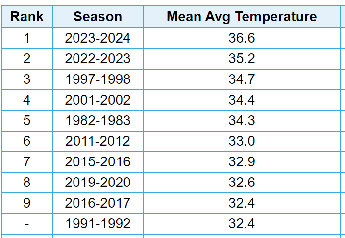
With meteorological winter in the books, here is how things shaped up in southeast Michigan.
It was the fourth warmest in the threaded record (dating to 1874-1875). It was the warmest on record at Detroit City Airport (dating to 1933-1934) and the warmest on record at Detroit Metropolitan Wayne Airport (dating to 1958-1959). Interestingly, the 36.6F mean temperature at DET [which was the official observation site from 1934-1966] would have placed second warmest in the threaded record. Last winter's value of 35.2F would have placed third [or fourth if you also included this winter].
The station thread is as follows:
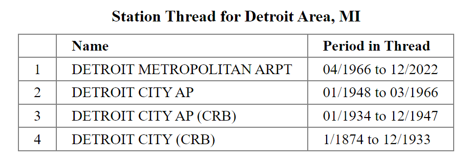
Threaded record
City Airport
Detroit Metropolitan Wayne International Airport
Pretty telling and concerning 7 of the top 10 warmest winters are in the last 27 years and 5 in the last 13 alone. Although a few others did not make the top 10 for Detroit, there's several other warm winters or winters with an abnormally warm month in that 27 year span including 1998-99, 1999-00, 2005-06, 2012-13, 2019-20, and 2020-21.
Warmth is one statistic and snow is another. I'm more concerned about the warmth and its severity and longevity during the winter season than whether we end up with above average snow. Because if we continue on this trend, we won't see many snow cover days or may struggle with precip issues with every storm. The period between 2007-2015 was the only real cold period filled with snow/cold that we honestly had since the 90's. And many of the 90's winters were shit too.
-
2
-
-
7 hours ago, 40/70 Benchmark said:
Early lead candidate for me is 1998-1999, which woud actually be a notable improvement over this past monstrosity.
At this point, anything will be better than this winter's monstrosity.
I'd take a repeat of 98-99. Biggest problem for me is that it was a warm winter too and I'm sick of these constant warm winters. But we had that blizzard in January 1999 that dumped 16-20" in Toronto and cued one of the snowiest 2 week periods ever in Toronto for a total of 46" in just 14 days. Kind of similar to Feb 2015 for you guys.
-
1
-
-
1 hour ago, michsnowfreak said:
How far back to YYZ records go? Surprised none of those warm 1870s-80s winters weren't on the list.
1957-58 and 1965-66 locally had warm, wet Decembers followed by cold dry rest of winter. Each had less snow here than this winter and were really many weenies nightmare pattern (warm and wet to cold and dry). It's surprising that 1957-58 wasn't warmer (outside December) due to a strong Nino and many mild winters preceeding that year.
1972-73 was interesting. It was amidst one of the coldest stretches of the climate record, so I'm wondering if that made it a bit colder overall (arguably the same for 1965-66). We had enough snow to make it an avg snow season (even a tick above at the time). January was warm and snowless but Feb was cold. The first half of March was and still is the warmest on record then we got slammed with a big St Paddy's day snowstorm.
Some historic strong Ninos that were very warm winters include 1877-78, 1905-06, & 1918-19. Most areas had little snow as well (esp 1918-19).
My take is that strong Ninos are going to have other factors at play (the current weather/climate cycle of the time, Pacific, blocking, PNA, NAO, etc) but in the end, a strong El Nino is never a sign for a good winter, at least in the Great Lakes.
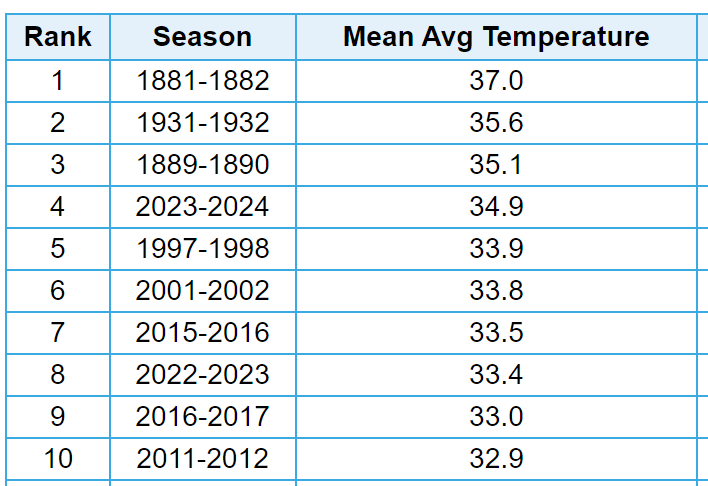
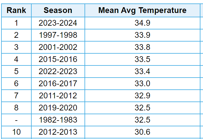
YYZ only goes back to 1938. Here's the top 10 for Toronto going back to 1840. I used Toronto till the mid 1950s and YYZ thereafter because of the continued industrial revolution skewing anomalies. As of now 1931-32 holds the title for us. I guess you could make an argument that those pre 1955 winters if they happened today with all the UHI, they would be a lot warmer. Therefore, for that time, which is considered to be a much cooler time globally, those winters were incredibly warm vs normal.
We lucked out in 1965-66 with 27" in January but snowfall outside of January was abysmal. And 1957-58 was shit here too, snow wise. Temperature wise both winters finished slightly above average but not by much. We finished near average for 1972-73 too, primarily thanks to a snowy November and December where 60% of our winter snow fell in those 2 months.
I made a post in the other thread about strong Nino's. Every strong/super Nino since 1982-83 has been an absolute blowtorch across North America. Quite the opposite with other notable strong Nino's like 1972-73, 1965-66, and 1957-58. It seems like 1982-83 was the tipping point. Though aside from the temperature anomalies, one thing remains constant. They were all largely snowless for the entire region. We seem to fair much better and snowier with strong La Nina's. Of the majority of YYZ's top 10 snowiest winters, most are strong Nina's. I'd assume it's the same for Detroit.


December 2024
in New York City Metro
Posted
Off topic, but is NYC worth visiting pre Christmas or is that all just movie/social media hype? And why are hotels in Manhattan so expensive rn.