Snowstorms
-
Posts
4,094 -
Joined
Content Type
Profiles
Blogs
Forums
American Weather
Media Demo
Store
Gallery
Everything posted by Snowstorms
-
i agree, I'm in the same boat as you. Although its been nice seeing the consistent light snows everyday, it's getting a bit frustrating now. And I'm a huge winter weenie like you. I'm not sure about Detroit, but normals aside, this cold hasn't been anything extreme. For us its been a seasonably cold pattern. Our average low is around 13 and YYZ has only gotten below 13, 8 times so far. Our coldest wind direction is usually from the NW or due N and the wind direction this month has primarily been from the SW or WSW. That plus the consistent cold cover due to the warm lakes has prevented us from dropping below 13F more frequently. Just an overall crappy pattern tbh. Although there's been some glimmer of hope on the models for a possible pattern change, its constantly being pushed back. Remember 2 weeks ago the models had a nice -EPO/Aleutian ridge pattern around Jan 20 and its now Jan 24 and the pattern remains unchanged.
-
That massive +PNA ridge which has centered the trough right over the east has been killing any storm threats. I prefer 13-14 that featured an Aleutian ridge/-EPO pattern with a neutral to slightly negative PNA.
-

Fall/Winter '24 Banter and Complaints Go Here
Snowstorms replied to IWXwx's topic in Lakes/Ohio Valley
This cold has been nothing special so far. YYZ has only gotten lows below -10C or 14F 6 days this month. For reference, we got below -10C/14F, 21 days in Jan 2022 and 14 days in Feb 2021. Our seasonal average low is 13F right now. The lakes are still running above average and with a lack of proper snow cover, it is hindering our ability to cool down or stay cold. Lack of any extreme cold or cold rivaling prior winters like Jan 2022 or Feb 2021 + a lack of any storms + the daily 0.3" and constant cloud cover, makes this winter close to a disaster. -
Winter 2024-25 Medium/Long Range Discussion
Snowstorms replied to michsnowfreak's topic in Lakes/Ohio Valley
Nothing to track in the medium range for the entire sub. This entire upcoming week will be dry and cold. The lack of storms is appalling. -
@mississaugasnow Your area must be getting some nice lake effect snow today off Lake Ontario. Nothing up this way except some flurries.
-
Winter 2024-25 Medium/Long Range Discussion
Snowstorms replied to michsnowfreak's topic in Lakes/Ohio Valley
Haha I was implying there's nothing worth tracking in the foreseeable future for any of us in the sub. And that's on top of going half the winter without anything either. It's just endless cold and occasional 1-3" clippers. -
Winter 2024-25 Medium/Long Range Discussion
Snowstorms replied to michsnowfreak's topic in Lakes/Ohio Valley
Not a single fantasy storm on the models. This winter is the epitome of disaster. -
Winter 2024-25 Medium/Long Range Discussion
Snowstorms replied to michsnowfreak's topic in Lakes/Ohio Valley
I've appreciated the consistent snow days. It's definitely made it feel like winter. While disappointing to see everyone getting a chance to score, our time will come. Need to move that big ridge across the PNW towards the Aleutians and Alaska for the SE ridge to flex a little bit and help create a gradient. Our best and biggest storms come from patterns like that. EPS has been hinting at that near the end of January, but it keeps getting pushed back. -
Got lucky with the georgian bay streamers a few times that gave us an extra couple inches haha. Otherwise its been the couple clippers that passed through the region. Need a classic Colorado or Texas low. Or just give me a repeat of Jan 22 which happened exactly 3 years ago today. What a storm that was. Widespread 16-20" with some spots receiving 24".
-
Winter 2024-25 Medium/Long Range Discussion
Snowstorms replied to michsnowfreak's topic in Lakes/Ohio Valley
La Nina needs to La Nina for us to start scoring. The pattern so far hasn't been that of a typical Nina. -
Lake effect is nice but incredibly localized. A single squall line could literally be only 15-20 miles long in width meanwhile the people outside that boundary are dry and snowless. Made it up to 19.5" here in Toronto thanks to these 1-3" clippers and lake effect. Still running below average though for the ytd.
-
Winter 2024-25 Medium/Long Range Discussion
Snowstorms replied to michsnowfreak's topic in Lakes/Ohio Valley
So have most of the Great Lakes region. Some of us have 1-3" our way to 10"+ but weak clippers or lake effect snow don't count. But for those that haven't even experienced that, I truly feel for y'all. -
Been snowing since the morning, lightly to at times heavy, and picked up a good 1.7" today. Puts me at 19.3" for the season.
-
Winter 2024-25 Medium/Long Range Discussion
Snowstorms replied to michsnowfreak's topic in Lakes/Ohio Valley
Canada has been cold. It was -50 a week ago in the Yukon and in the -40's this morning in Nunavut. The problem has been the warm lakes after experiencing 2 consecutive blowtorched winters and lack of sea ice across the Hudson. I think this is the latest Hudson Bay has gone without freezing over. But I agree, we will see some of the coldest air since 2019 across the region next week. I believe one of the reasons Siberia is colder than Northern Canada is the lack of land mass across Northern Canada vs one giant country on the other side of the pole. The vast open ocean and lack of any huge land mass limits how cold Canada can get. That helps drive the Siberian high. But the lowest temperature ever recorded in Canada was -81.4, not to far from Siberia's lowest of -89.9. -
Thats not possible. The first ever plane wasn't invented until 1903. The word airport probably didn't even get invented until after. What use is a port if there's nothing in the air?
-
Winter 2024-25 Medium/Long Range Discussion
Snowstorms replied to michsnowfreak's topic in Lakes/Ohio Valley
We will see if that happens. The cold this month so far hasn't been impressive, its been seasonal cold. The culprit is the warm lakes and lack of sea ice across Hudson Bay and Baffin Island which still hasn't frozen over yet. Might be the latest on record? This duo may modify the temps and prevent us from experiencing a severe cold outbreak like we did in mid-late Jan 2019 or late Dec 2017. Not complaining about these 1-3" events but going 1.5 months into winter without a trackable event is total zzz. -
The bottom image looks more like a neutral EPO and strong Aleutian ridge pattern, typical Nina look with the weak SE ridge.
-
Thank you and @donsutherland1 for sharing that. Those top 10 winters in your list were also impressively cold here too. 1874-75 actually beat 1976-77 by a hair. But the severity of the cold in 1976-77 remains unmatched. Toronto went a staggering 51 days below freezing in a row. 1977-78 was impressive too with 41 straight days. Almost all of our coldest winters were either cold Neutrals or weak El Ninos. Honorable mention is the February 1979 cold outbreak. We went 10 straight days below 14. I think even NYC with the exception of one day for a couple hours, practically went 15 straight days below freezing.
-
Winter 2024-25 Medium/Long Range Discussion
Snowstorms replied to michsnowfreak's topic in Lakes/Ohio Valley
Total snooze fest on the GFS. -
What are NYC's top 10 coldest winters since 1950, irrespective of normals. 1976-77 is Toronto's coldest winter as well with a mean temp of 16.8 for DJF. 1969-70 and 1944-45 are tied for second and 1993-94 and 1977-78 are tied for third.
-
Most of us living in the Great Lakes are running warmer than normal this month when compared to the old 81-10 normals vs the blowtorched 91-20 normals. I've only gotten down to 8 so far this month, which is nothing impressive, given our average low of 13 currently. Those living in the path of the snow belts are doing amazing, snow wise. Most of us aren't. I've been fortunate enough, which is rare btw, to get a few lake effect streamers which have given me a grand total of 7" since Dec 1 of the total 17" for the season. The rest was cause of clippers, 1-3", here and there. It's crazy what consistently warm winters can do to lake temperatures.
-
Nice clipper, just wish we could've stolen some more moisture from that storm down south haha. Clipper'd and lake effect snowed my way to 17" and around 14" at YYZ on the season. Of the 17.6" at my place, about 7" is from lake effect alone. Still running below average though.
-
Nice to see the Mid-Atlantic snow covered. It's been a long while, happy for you guys
-
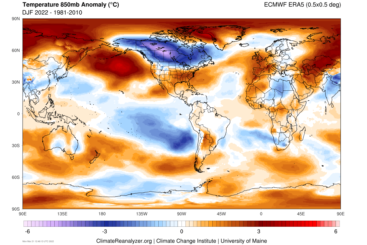
I think his idea of "canonical La Nina" are winters like 2022-23, 2011-12, 1999-00, or 1998-99 which were straight blowtorches, but they weren't necessarily because of an overpowered SE ridge. A true canonical La Nina winter has cold anomalies centered across the Upper Midwest, Plains, and Canadian Prairies and neither of those winters above had that with the exception of 2022-23 in a few spots thanks to a really cold December. A true canonical La Nina winter may feature warm periods in the east but equal amounts of cold shots or a cold winter month or two, i.e., Dec-Jan 2009, Dec-mid Feb 2018, etc. Temperature wise, 2021-22 was the last true canonical La Nina winter. The warm anomalies in the south are primarily because of a near record warm December. That was likely driven by an overpowered SE ridge, +AMO, and climate change.

-
Clipper overachieved here. Measured 3.8". Most areas of Toronto received 4-6" thanks to some lake enhancement. At least it finally looks like winter.