Snowstorms
-
Posts
4,126 -
Joined
Content Type
Profiles
Blogs
Forums
American Weather
Media Demo
Store
Gallery
Everything posted by Snowstorms
-
Hey we in Toronto are in the same boat too. Fall usually signals the end of thunderstorm season and the start of more typical Fall storms. Better chances of rain with them as thunderstorms are more localized. He'll catch a good vibe then.
-
OT but starting to see that 540-line popping up especially across the northern parts of the sub forum on the LR GFS. Even starting to see some blue hues popping up in the Canadian Prairies. Real good chance we see our first real taste of Fall near Labor Day given current teleconnection forecast (+PNA/-EPO). Fall is coming.
-
Yeah, I just saw the radar. About to cross over to Lake Erie. Impressive line of severe thunderstorms, hearing reports of near hurricane force winds. Hopefully the storms tomorrow night and Saturday pan out. Dynamics look good for widespread t-storm development including Kitchener.
-
It was modeled to miss you. For us here in the city, the Niagara Escarpment can tear apart storms before they reach us but you're far away from it. Can't even use that excuse
-
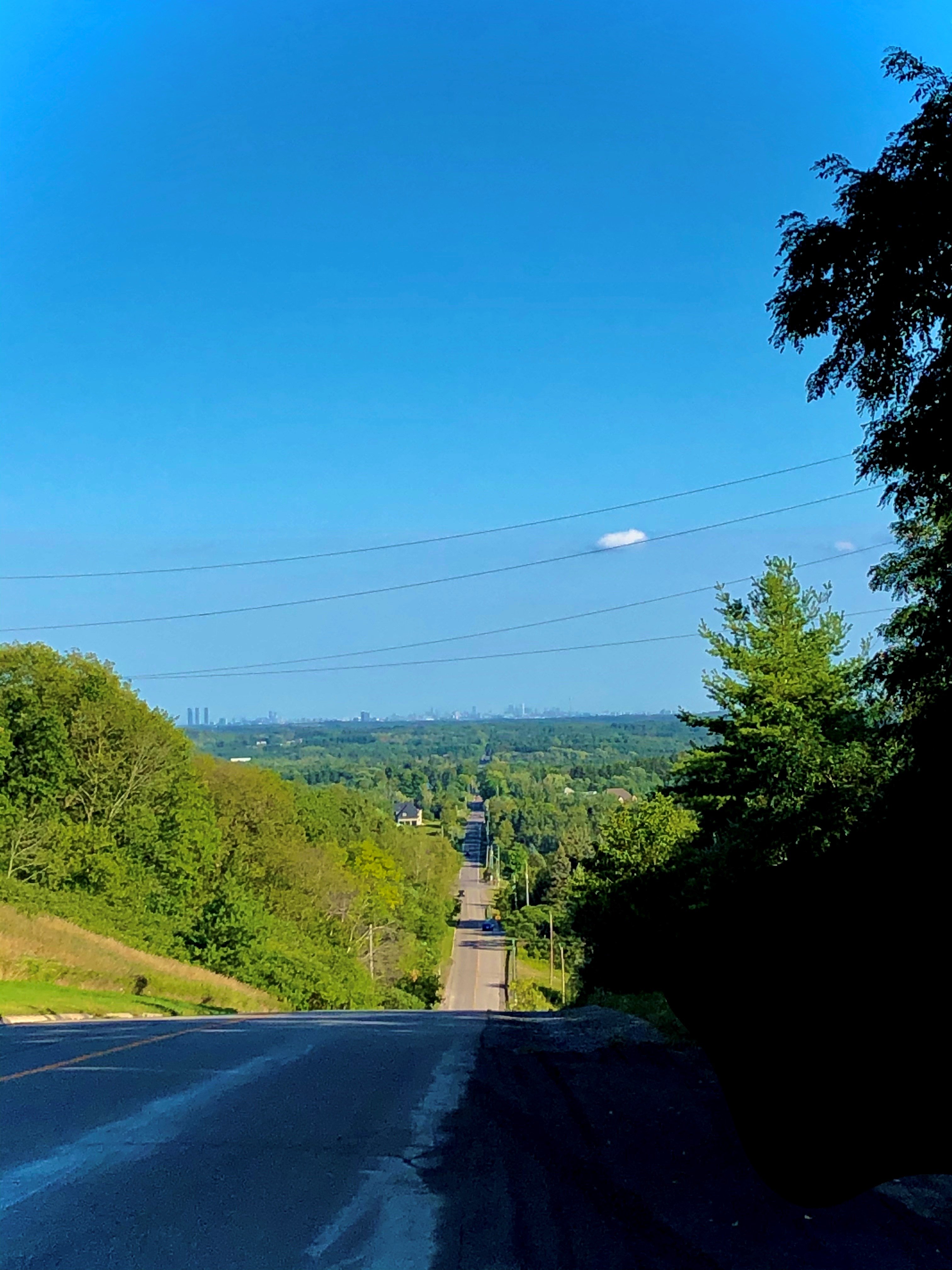
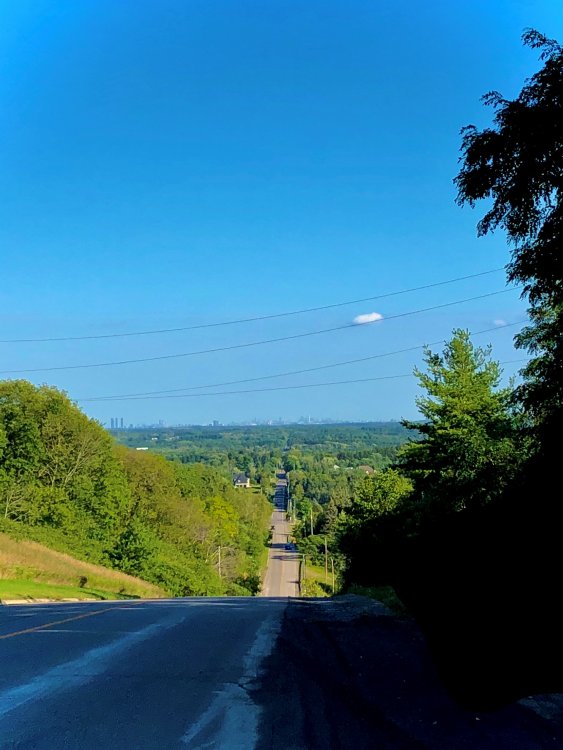
Took this shot a few days ago as I was driving back down from a friends house. You can see the city in the background. Not a whole lot of humidity even tho the temp was ~88F. This area borders the Oak Ridges Moraine, hence the higher elevation.
-
Didn't even make it to 70F yesterday. Already up to 83F today at last obs. A lot of cloud cover though. Hopefully it clears up.
-

2019 ENSO
Snowstorms replied to AfewUniversesBelowNormal's topic in Weather Forecasting and Discussion
Most recent MEI value (JJ) was -1.0 which is borderline moderate La Nina. The new value for JA may come in higher as we've seen more progressive cooling across all ENSO regions through-out this month. Further cooling should continue over the next few weeks as a strong trade wind burst is expected next week esp over western ENSO regions. The new MEI v2 uses 5 variables compared to the old MEI which used 6. I prefer MEI as it takes into consideration all ENSO regions compared to ONI. -
Heat wave is over for us. Currently 66F with an expected high ~75F today. Got down to 57F last night. Had the windows open, felt real nice.
-
3.33" this month so far at YYZ but that number is deceiving. 3.1" of that fell in 3 days earlier this month. In reality only 4.2" has fallen since July 12th. Models are showing couple thunderstorm risks tomorrow and the chance for more steadier rain Friday night into Sat morning. Let's see if that verifies. Been dry as hell.
-
Been a boring ass summer. Barely any severe thunderstorms and the thunderstorms we did get were either late in the evening or at night lol. Even with all the extended periods of dry weather we got this summer, not one day was cloud free. Aside from the extreme heatwave we had in early July, we haven't had anything remotely close to that all summer. The heatwave going on right now isn't anywhere as extreme as that was. Today was the first day all month that Toronto hit 90F lol.
-
It sucks to live downwind of the lakes especially when you've got Georgian Bay, Lake Simcoe and Lake Huron to your north and Lake Ontario to your south. In the summer, you can never get a full on sunny day because by the late morning, the clouds start rolling in and it becomes partly cloudy until sunset. On the other hand, in the winter, the Sun hardly comes out lol.
-
A line of strong thunderstorms, primarily non-severe, off Lake Huron this morning literally disintegrated as it approached Toronto late this morning. Story of this summer. It hasn't rained, even a drop, since August 4.
-
Nina winters with some NAO blocking are epic, i.e. 55-56, 64-65, 70-71, 95-96, 08-09 and 10-11.
-
They've made masks mandatory in all indoor settings including apartments and condominiums (public areas). Gyms and fitness centers finally opened up after being closed for nearly 5 months. I believe they're contemplating on keeping that US-Canada border closed until December.
-
We received nearly 4" of rain these past 3 days. Did not see that coming. Now to enjoy some nice sunshine and seasonal temps for the rest of the week. Toronto was under a tornado watch today. Second time this year, pretty crazy.
-
Got ~25mm yesterday in my area with that storm cell. Better chance this weekend for some more widespread thunderstorms. We'll need to watch the "tropical" storm coming up the east coast and where it tracks and how it interacts with the low coming in from the Midwest. That will determine where the thunderstorms develop over the weekend.
-
Need some serious rain. Only 0.3" since June 10th. Spring was dry too. Grass is literally toast out here.
-
It's May 19 and we have yet to crack 70F here. The last time it was 70F was back in early October. I feel you. . Just a few more days of this crap.
-
You and @mississaugasnow both live in the wrong country if you expect constant blowtorches and heatwaves. We got spoiled with above average May's from 2010-2016 raising our expectations for May temperatures. But to be fair, what we're seeing this weekend and into next week is typical weather for May. I think it's time you take a trip down memory lane and look at other May's like 2008, 2005 and 2002 just to name a few. All of them expect 2008 transitioned into a hot summer despite being well below normal in May. We only average 12 days above 20C in May. There's still 15 days left and we've had one officially at YYZ so far. May is NOT a summer month for us.
-
2019 ENSO
Snowstorms replied to AfewUniversesBelowNormal's topic in Weather Forecasting and Discussion
The ONI is more widely used to categorize ENSO events, but I prefer MEI as it takes into consideration more variables. The 2010-11 La Nina was the last strong Nina event. The coldest anomalies were centered around Region 1+2 and 3 as opposed to Region 4, atleast in the beginning. So there is a chance we could see a pretty healthy La Nina event if the upwelling continues. Haven't dug deep into this year's ENSO event but will be doing so over the next few weeks. Your posts are always informative, great work! -
Now that you mention it, a friend of mine got stung by a yellow jacket on his head on that exact weekend last year near his cottage. Was not a pretty sight.
-
Just like those pesky wasps.
-
When I went grocery shopping last week, I saw numerous bottles of hand sanitizer. It was sold out everywhere prior to that. Limit was 2, so I grabbed 2 lol. Now we wait for Lysol and/or Clorox wipes to be restocked.
-
Did you see that video of him putting a mask on?
-
3-15K alone is devastating but 100K is just catastrophic. We've seen over 400 cases a day now for the last few days. Apparently were not testing as vigorously as other countries are so that number could be a lot higher. Correct me if I'm wrong tho. I don't know if you've heard but some family in Brampton got fined 100K for throwing a "party" despite Ford prohibiting gatherings of more than 5 people. My WFH got extended till May 1 now and I suspect it may get extended again as we approach the end of the month. April will be a rough month but if these social distancing measures are increasingly forced, then May can end up a lot better.