

Snowstorms
-
Posts
4,094 -
Joined
Content Type
Profiles
Blogs
Forums
American Weather
Media Demo
Store
Gallery
Everything posted by Snowstorms
-
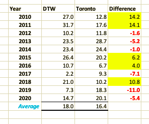
I agree. Meant to get back to this post yesterday, sorry. We have the same disparity in Toronto. I believe the seasonal total is close to 8-9" near the lake for the season compared to 17-20" just away from the lake. This winter has been terrible for snow-cover no doubt. Although we're at 18" for the season it doesn't feel like it one bit. 31" in Feb 2011? Holy shit. I compared Toronto and Detroit below. It's a mix bag but 2010 and 2011 are the main reason why Detroit's Feb average is higher than Toronto rn. Crazy run for both cities, regardless.
-
Christmas miracle storm today for Toronto and surrounding areas including Hamilton, Niagara county and Kitchener. Potential for 4-8" (10-20cm) by tomorrow morning. There will be an intense but brief (1-3 hour) burst of heavy snow later this evening as the deformation band moves through the area. Temps are crashing everywhere. Let it snow!
-

Winter 2020-21 Medium/Long Range Discussion
Snowstorms replied to Hoosier's topic in Lakes/Ohio Valley
The 500mb pattern advertised on the models next week is the best H5 look we've had in years. Massive ridging near Greenland and a 50/50 Low off Newfoundland. The Pacific is a convoluted mess right now but the ridging near BC is literally perfect for a nice storm for the Lower Lakes/OV. It's just about timing. I feel the storm will correct south over the coming days. There's just a lot of moving parts for model consensus. This storm won't be sampled until Tuesday, almost a week out. -
Winter 2020-21 Medium/Long Range Discussion
Snowstorms replied to Hoosier's topic in Lakes/Ohio Valley
I wouldn't throw in the towel yet. This storm is still a week out and I suspect a lot of variability until then. The current storm is definitely having an impact on model consensus. The key thing to watch is the late weekend storm and how fast it can move out and deepen. Right now models are keeping it relatively weak which enhances the ridge developing off the east coast out ahead of the Low. However, there's a massive ridge near Greenland (-NAO) and ideal ridging across the PNW which should help to counter the developing ridge and suppress the storm. The strong HP sitting in Wisconsin had zero impact on the storm and that's why I have a hard time buying the Euro. The GGEM is more realistic imo. I think this could be a good storm for Chicago. -
Models are converging on 10-20cm (4-8") from Niagara to Hamilton to Toronto tom night into Christmas morning. There will be a brief but very intense burst of heavy snow, where most of the snow should fall, due to a strong mid-level FGEN band setting up as the secondary low takes over. Looking good for parts of Ohio as well. Most of eastern Ohio is locked in for a good 4-8"+. There could be some freezing rain and ice pellets initially as the gradient cuts through before transitioning over to heavy snow.
-
Winter 2020-21 Medium/Long Range Discussion
Snowstorms replied to Hoosier's topic in Lakes/Ohio Valley
It's colder in Houston than Chicago at Hour 192. Cool. -
Winter 2020-21 Medium/Long Range Discussion
Snowstorms replied to Hoosier's topic in Lakes/Ohio Valley
That 1040 HP sitting in Wisconsin gets kicked out and does absolutely nothing in suppressing the storm. -
Winter 2020-21 Medium/Long Range Discussion
Snowstorms replied to Hoosier's topic in Lakes/Ohio Valley
I use SAP at work, a German software. I can attest to this. It's good. -
Winter 2020-21 Medium/Long Range Discussion
Snowstorms replied to Hoosier's topic in Lakes/Ohio Valley
Those images belong here.
-
Winter 2020-21 Medium/Long Range Discussion
Snowstorms replied to Hoosier's topic in Lakes/Ohio Valley
Need better cooperation on the Pacific side. We'll see if the HP descending into Mongolia and parts of Siberia next week will have any inverse effects further east across the North Pacific. The AO has been negative all month, but the Pacific is putrid. We haven't seen any legit cold shot yet. -
Mean spread is still all over the place but at least they’re east of NAM or RGEM expect for one lol. All in all, good for the GTA. Let's see if that trend continues tonight.
-
Yeah I agree. For people along the Lake, like yourself, it's been a terrible start to winter. YYZ is ~43cm for the season and only 75cm away from our seasonal average. Everything is going well my friend, hbu? Been wfh since March. Just bored and tired of being trapped inside with nothing to do and nowhere to go. Now with the lockdown looming combined with winter, it's only going to make people like myself more depressed lol. I agree. I hope the storm will be bigger than expected right now so it forces people to stay home for Christmas. At the same time, I can tell you a lot of people are tired of staying home so they might just go anyways. Lockdown doesn't start till Christmas night.
-
Still room for shifts. Extremely tight gradient but a lot of factors impacting the exact strength and track of that secondary low. The main thing imo is how much the trough digs. I'd say tonight’s 00Z runs will be key but tomorrow's 12z runs will give us the best clarity. Potential is there for either 1-2" (2-5cm) or 4-8" (10-20cm). Not going to write it off just yet.
-
Very interesting set-up. The operational NAM was further west, like the RGEM, but the high-resolution NAM was much cooler at the surface. Which suggests stronger dynamic cooling as the initial low parks up over Hudson Bay keeping the WAA at bay. We’re riding an extremely tight gradient here. Depending where that gradient sets up, someone from Windsor to Toronto will have a brief but very intense burst of heavy snow with a fast-moving deformation band. The CMC digs the low more than the 3KM NAM and that pushes the secondary Low further west. You remained optimistic about this set-up from the start so let's hope that optimism pays off.
-
18"? Wow. Our Feb average over the last 10 years is 16.7". Your seasonal average over the last 10 years has definitely surpassed Toronto's average. Been much snowier in SEMI of late compared to surrounding regions. There's some missing data at YYZ this month so I can't tell you the actual figure but I am certain its ~17" which puts us above average to date. We've officially surpassed 2011-12 LOL. Only 4" short of our seasonal avg for December. A few other stations across the city are above 20" already. Close to 20" imby too. How is Detroit?
-
It’s sad when strong winds are the only exciting thing to talk about in December.
-
Solid points. December 2016 wasn't really all that cold tbh. Only December 2013 and 2017 were well rounded Decembers of late. I love a good November snowstorm but to take that followed by a snowless December? Nah. November snow and cold barely last more than a few days and the excitement of it dies out quick. We did get spoiled yes, but this stretch we are going through right now is equally comparable. February has been exceptional over the past 20 years locally. Our February average since 2000 is close to 14" lol. But similarly, other months especially Dec, Jan and Mar have taken a big hit. We got shit in March 2017 and 2018 so lucky you. March 2014 was our last above average month and before that March 2011. Tired of these half ass winters we keep getting.
-
I think what's most frustrating is losing December again. 3rd warm December in a row and our 7th since 2010. That's just straight up ridiculous. Would be nice to get some good snowy cold Decembers again and not have to continually rely on January or February for snow. It's been years since we've seen a nice widespread March snowstorm as well. Seems like winters are continually being condensed into 2 months and it's becoming really frustrating. Losing December as a snow lover hurts, it's the worst.
-
I haven't seen a good March snowstorm since 2014. Just dry cold without any decent warmth. Terrible.
-
I hope it's not some half ass lockdown. This Toronto and Peel lockdown hasn't done anything to reduce case numbers. It's either you go all in or you don't at all. Hopefully we start seeing vaccinations ramp up. My girlfriends’ brother is a doctor in Virginia and recently got both vaccine doses. He's doing great and if there are any side effects with these vaccines, they would likely occur within 48 hours should anyone get them. I'm tired of this and just want to move forward.
-
You're right. It was a boring year. Only a few things come to my mind. - January rainstorm. (3" of rain. Has never happened before). - Rare May snow and cold (1.2" locally). Snowiest May ever - July heatwave. Widespread 90's across the sub - November record breaking "heatwave" (as mentioned) - November snowstorm (8-10" locally). 3rd biggest November snowstorm ever
-
Gonna be a rainer. A Grinchmas storm.
-
Got like 2.2cm (0.9") so you beat me this time. I agree. There was a nice winter feel this morning, but it'll be back above freezing by this weekend. We need a nice widespread storm like Feb 2013. Tired of all the disappointing Decembers we've been experiencing.
-
That’s crazy. The only storm that comes to my mind that is comparable in amounts is probably the Blizzard of 93. And that storm was 2-3x the size of this one. Give me a storm like this in Jan or Feb. Thanks!
-
That's just nuts. 40" and all synoptic. Even crazier when you step back and realize it all fell within 24 hours. 40" wow! Our seasonal average is 45". They got 95% of our average in one go. Why couldn't this storm be another 150-200 miles further west? I'd happy if we even get half that in a storm this winter lol. Seems impossible.


