

Snowstorms
-
Posts
4,094 -
Joined
Content Type
Profiles
Blogs
Forums
American Weather
Media Demo
Store
Gallery
Everything posted by Snowstorms
-
A picture perfect day for a snow lover like you.
-
You're right. And they did long ago but massive budget cuts have led to limited stations now lol. And if you're going to cut back on stations, then at least improve the way you record data at the existing ones.
-
You do have a good point but for a long time while the "Toronto" station was operational, it was usually recording more than YYZ. And that "Toronto" station was in downtown near University of Toronto, if i recall, based on what another poster here was saying. It's been recording data since 1840. I'll give you an example. That Toronto station recorded an astounding 84" during the 1959-60 winter vs 55" at YYZ. That 84" is a random winter that nobody has ever talked about, but it recorded more snow than the official snowiest winter at YYZ (1938-39) lol. Based on that alone, YYZ has always been questionable. Buffalo's differences might be attributed primarily to lake effect as LES is always localized. Plus, unlike EC, NWS has like 10 stations per city lol. Temperatures I do agree with and thats because of the urban heat island effect which is more profound in rural vs urban areas.
-
I do agree. Areas much closer to the lake tend to be warmer and less snowier than areas further inland. This winter is a good example of that. However, mathematically speaking, YYZ and EC's headquarters are almost on the same plane. Both stations experience similar temperature's when it snows but vary during non-precip days. I'm not sure if YYZ still uses the nipher because the differences have substantially improved and almost netted out to near zero over the last 6 years but man, 2004-2014 was really bad lol. I know for a fact 07-08 was unofficially the snowiest winter ever recorded at YYZ, but they lowballed the Mar 08 storm quite a bit. YYZ only recorded 6" whereas every station in the GTA recorded 13"+. Hence why North York has averaged around 51" over the last 29 years, which I feel represents many areas quite well around the 401 and north towards Vaughan minus northern regions of Vaughan like Maple, Teston, etc.
-
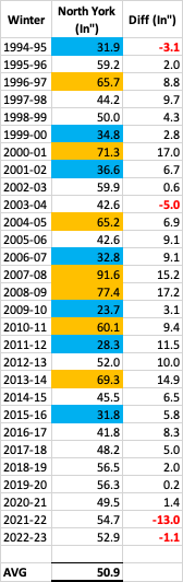
I agree. The first time since 2022 where it's felt and looked like winter for an extended period of time. I was bored so I looked at the total snow accumulations at North York (where EC is headquartered). North York began recording data in Nov 1994. I compared it to YYZ to see the differences in amounts. Let's just say YYZ is an actual joke and this whole "nipher" thing needs to be abolished. The ones in red font below are where YYZ recorded more snow than North York. The ones highlighted in blue are the exceptionally below normal winters and the ones in orange are the exceptionally snowy ones. Winters like 2000-01, 2007-08, 2008-09, and 2013-14 stand out like sore thumbs. Consequently, North York has averaged 50.9" over the last 29 winters vs. 45.2" at YYZ. Edit: Fixed the "winter column".
-

Winter 2023/24 Short Range Discussion
Snowstorms replied to Chicago Storm's topic in Lakes/Ohio Valley
Got an inch today from the disturbance impacting the east coast. Gave it a nice wintry feeling with 4" on the ground now. -
Nope they didn't, you're right. Dewpoints were in the low 50's. Most of the heat they experience in the PNW is dry, desert like heat. Quite different than the heat we experience in the Midwest and GL's. The lakes, especially if they're ice-free or have very little ice, regulate a lot of the temperatures we experience in the winter. It's even more prevalent in areas adjacent to the lakes. Otherwise our climo would probably be similar to the Midwest imo.
-
Time you move to Yellowknife. Here's their forecast for the next 7 days. Every single night for the last 7 days has been below -40F. https://weather.gc.ca/city/pages/nt-24_metric_e.html
-
I beg to differ. Parts of interior BC got up to 120F during the 2021 heatwave, shattering all time records. And BC is practically all mountains except the immediate coastline. However, I believe mountains can definitely play a larger role when it comes to precipitation. That's evident in BC where Burnaby (near Vancouver) averages 79" per year whereas Kamloops, 4 hours inland, averages only 11".
-
Total snoozefest next 8-10 days. And that'll pretty much take us until the end of January. Finally got some cold air and the storm production shuts off. I'd say the pattern change was a semi-fail. We got two big storms in less than a week with nearly identical tracks but there was no cold air around for any substantial snow for most of us (minus parts of Michigan, Iowa, and Illinois). Kinda sucks. Hoping the last few days of the month, despite a potential warm-up, or February play out better.
-
Yeah I still got a solid 3". I was at YYZ today to pick a friend up and there's about 2" on the ground there too.
-
Had 4.2" with that initial banding before it switched over to rain. YYZ recorded 2".
-
April 1939 had a big snowstorm. Over 10" at YYZ. April 1975 also had a 9" storm. It's not rare but can happen occasionally like it did in April 2016.
-
Nah. The stats you see in my sig are of my own and I can tell you personally all 4 of those winters were bad to downright hideous. 09-10 sucked for us because every storm was suppressed thanks to the massive NAO block. I know areas just 100-200 miles further south had a completely different winter. 06-07 and 15-16 were virtually snowless until mid January.
-
Wow. So this cold outbreak is historic then. I think what makes it even crazier is the 180 degree pattern flip from December. Let's see if we can break some records then.
-
Oh I completely agree. It's way overpriced like everything else is in Canada but that's a topic for another day lol. I have an Eddie Bauer jacket. Does me good every winter. It doesn't get cold in Toronto like it does in western Canada but we typically get cold nights here and there between 0 and -15F almost every winter. Maybe i'll consider investing in an Arcteryx jacket too. Might be useful if I decide to go hiking or snowmobiling.
-
I consider it stat pad when you factor in seasonal averages. I'm not sure what the average high in Detroit is in early-mid April but I'm sure its probably close to 45-50F which is nearly 20 degrees above freezing. If you're a snow cover lover, April snow isn't your friend. It'll melt within 2 days with that high sun angle and warm climo. But I guess we can agree to disagree.
-
It won't but it's possible. April snow is just a stat pad. Most April/November snow is nothing more than 2-3" with that rare/odd 4"+ storm. We had a 8-9" snowstorm back in Nov 2020. Melted within 2 days because it was so warm which is why I don't care about early or late winter snow.
-
A lot of folks, especially in western Canada, have moose knuckles or canada goose jackets. Though I don't know how effective they are at -50F lol. But I don't think even your parka would be enough, you'd need to wear a thick sweater underneath along with scarfs, gloves, hat, etc. I have a cousin living in Calgary right now, I could ask him what they're doing. But I believe they urge people to stay indoors and park your cars inside a garage or risk it not starting up. I think they might even plug their cars. This type of cold outbreak is rare, even by their standards. On average most cold outbreaks are between -25 to -35F in that area.
-
5.5" at YYZ.
-
An October snowstorm is incredibly rare. I think it's only happened twice since 1938 at YYZ. There's less than 1% chance of it ever happening. And April 2016 we saw a nice 6" storm here in Toronto. Had it not been for that storm, we would've finished only an inch above 11-12.
-
For each of those winters, one month finished average while the rest were below to exceptionally below (almost futility months). I believe the 10 year stretch of futility winters we experienced is similar to the ones a lot of the folks down in the mid-atlantic are going through at the moment. 06-07, 11-12, and 15-16 were just down right bad. 09-10 had potential but to much blocking suppressed every single storm. April snow or November snow are nothing more than a stat pad. I could care less knowing it'll melt within 2-3 days max. I care about what falls between DJF until mid-march. And December and half of January now are pretty much a write-off and the next 10 days look cold and dry.
-
https://weather.gc.ca/city/pages/ab-71_metric_e.html It's currently feeling like -72F in Edmonton. -54F tonight and -58F tomorrow night in Edmonton without windchills. This is ridiculous cold.
-
Majority of the snow with this storm will fall within 2-4 hours today. All models have a very intense snow band pushing through between 6-10pm today. Snow rates will likely be 2-4"/hour with the possibility of thunder. Areas away from the lake have a good chance at 3-6". I can't say the same for you further south but just referring to the GTA @mississaugasnow.
-
I wonder how you'd feel or react if you experienced 4 top 5 futility winters in a mere 10 years. I don't think anyone on this forum knows futility better than us in Toronto. Although in those same 10 years, we had exceptional winters like 07-08, 08-09, and 13-14, the stinkers outweigh the good ones. Here's the numbers from YYZ just for laughs. 06-07: 23.7" (4th) 09-10: 20.6" (2nd) 11-12: 16.9" (1st) 15-16: 25.9" (5th) For snow lovers in Toronto, this was a nightmare. On that note, since 2019-20 every winter except 21-22 has been warm to exceptionally warm. Although we finished above average, it was all by luck. All marginal snow events which goes back to what @mississaugasnowwas saying. Would be nice to experience both cold and snowy winters like the 60s and 70s featured. We're basically reliving the late 80's and early 90's right now.


