Solak
-
Posts
6,434 -
Joined
-
Last visited
Content Type
Profiles
Blogs
Forums
American Weather
Media Demo
Store
Gallery
Everything posted by Solak
-
I *think* I read where there was a similar streak from 1950 - 1954.
-
Not in our area, but this is pretty crazy for the TX/OK area later today...
-
Euro = 594 death ridge. GFS = 595 death ridge. Pick your poison.
-
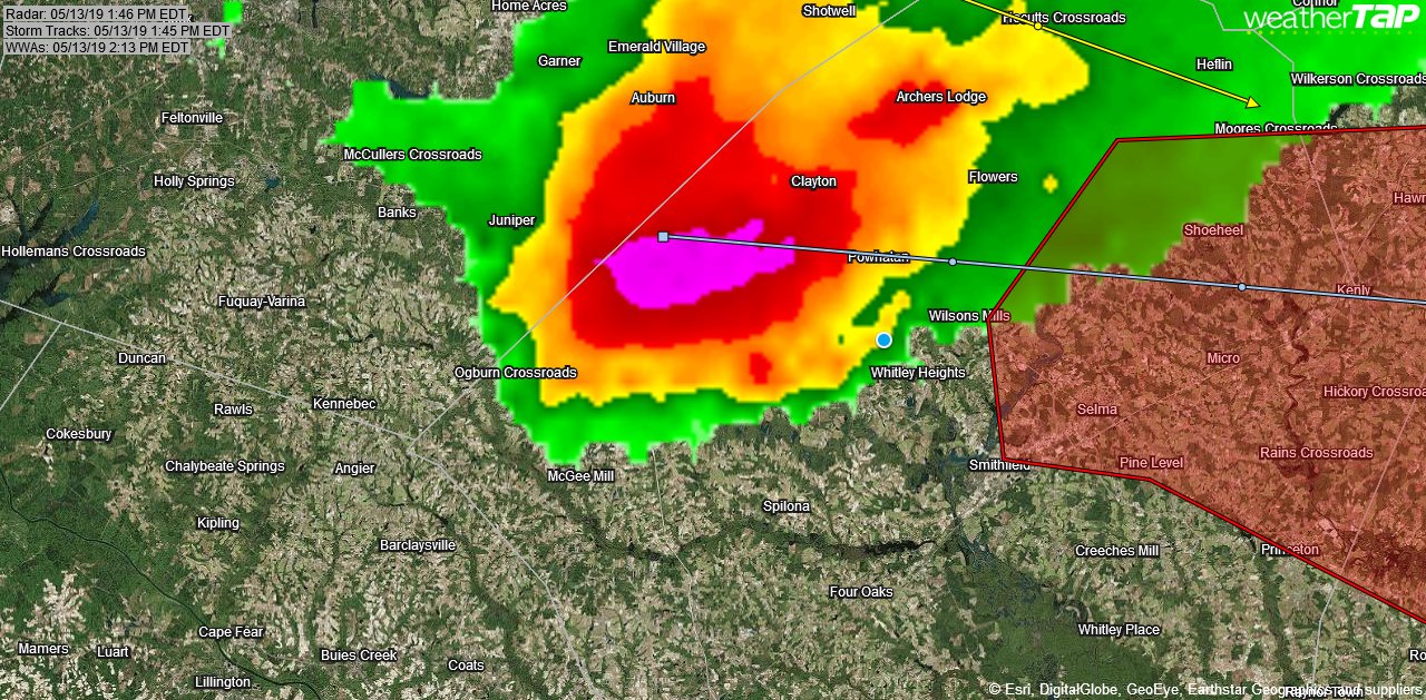
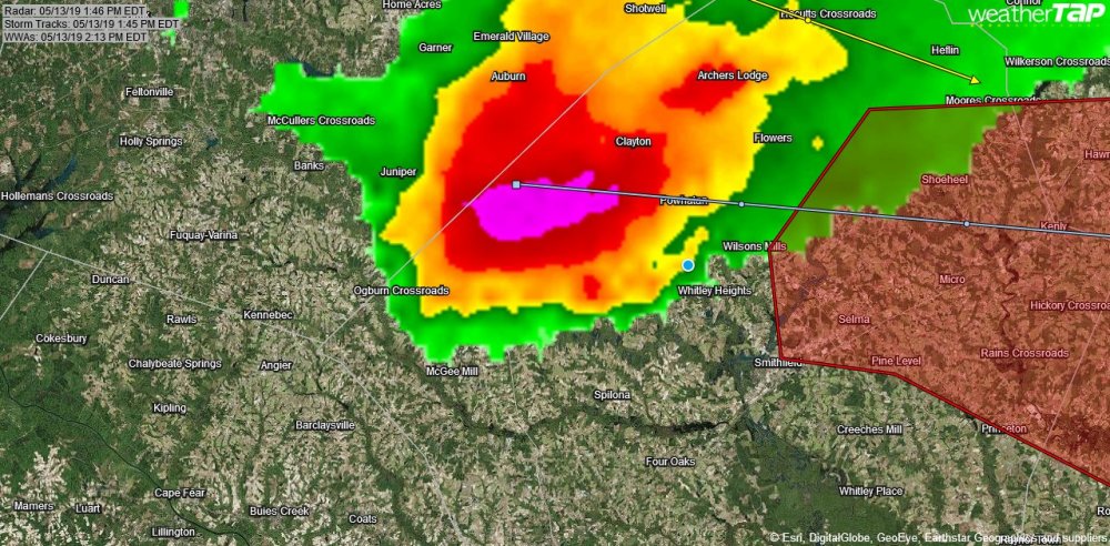
...NWS DAMAGE SURVEY FOR 05/13/19 EASTERN WAKE / WESTERN NASH COUNTY TORNADO EVENT... .EF-2 Tornado confirmed near Knightdale to Bailey North Carolina... Start Location...4 miles NE of Knightdale End Location...4 miles NNW of Bailey Date...May 13, 2019 Estimated Time...10:13 AM EDT - 10:39 AM EDT Maximum EF- Scale Rating...EF-2 Estimated Maximum Wind Speed...115 mph Maximum Path Width...385 yards Path Length...17.40 miles Beginning Lat/Lon...35.8275/-78.4399 Ending Lat/Lon...35.8288/-78.1371 * Fatalities...0 * Injuries...0 ...Summary... The tornado initially touched down just west of Rolesville Road near Tink's Place in eastern Wake County. The tornado initially produced widespread EF-1 damage with sporadic EF-2 damage noted on Weathers Road. Along the path to Weathers Road, numerous trees were either uprooted or snapped and mangled together, consistent with EF-1 damage. At Weathers Road, structural damage was noted as a single family home had its exterior walls collapsed. Several metal farm buildings were also completely destroyed and strewn about a field. Sheet metal was wrapped around a nearby tree. An RV was flipped over numerous times landing crushed in an open field. In addition, another home had the windows blown out with roof damage. It was in this area that EF-2 damage was determined. The tornado continued tracking east and crossed Edgemont Road just north of HWY 264/64, then crossing HWY 264/64 where numerous trees were downed and snapped. Generally EF-1 damage was noted here. The tornado then moved east into Zebulon along and near Highway 97 (West Gannon Avenue) where numerous trees snapped and uprooted. It continued east of Zebulon, crossing HWY 264/64 again, and going just north of the Five County Stadium. Generally EF-0 and EF-1 damage was noted here. The tornado then crossed into Nash County, where damage was observed on Brantley Road. Most of the damage consisted of trees being snapped and uprooted, with structural damage to an open-air farm outhouse. Just east on Massey Road, one newly constructed home suffered roof damage, with roof trusses severely damaged. Shingles had not been completed on the home yet, therefore this damage was considered EF-1 level. Also on Massey Road, a modular home suffered roof and wall damage, while two farm outhouses were severely damaged. The tornado then tracked east along Nade Road causing more uprooted and snapped trees. A home along Nade Road also lost its chimney with a cinderblock outhouse suffering complete roof failure. Finally, the tornado began to weaken as it crossed the woods east of Hoyt Road, and it eventually lifted just east of Winters Road.
-
Our niece's van got hammered...somewhere in the Cleveland/Clayton area, I think.

-
Hook was JUST to our N
-
Quarter size hail here at the house in that Tor Warned JoCo storm.
-
Not a good time for RAH Radar to be down for service.
-
Didn't expect this today... 1022 AM EDT MON MAY 13 2019 The National Weather Service in Raleigh has issued a * Tornado Warning for... Southwestern Nash County in central North Carolina... Northwestern Wilson County in central North Carolina... Northeastern Johnston County in central North Carolina... * Until 1100 AM EDT * At 1022 AM EDT, a severe thunderstorm capable of producing a tornado was located over Zebulon, or 18 miles east of Raleigh, moving east at 40 mph. HAZARD...Tornado and quarter size hail. SOURCE...Radar indicated rotation. IMPACT...Flying debris will be dangerous to those caught without shelter. Mobile homes will be damaged or destroyed. Damage to roofs, windows, and vehicles will occur. Tree damage is likely. * Locations impacted include... Nashville, Wilson, Bailey, Spring Hope, Middlesex, Sims, Buckhorn Reservoir, New Hope and Tar River Reservoir.
-
Tornado Warning National Weather Service Raleigh NC 451 PM EDT SAT MAY 11 2019 The National Weather Service in Raleigh has issued a * Tornado Warning for... Northeastern Anson County in central North Carolina... Southwestern Montgomery County in central North Carolina... Northwestern Richmond County in central North Carolina... Southeastern Stanly County in central North Carolina... * Until 515 PM EDT * At 450 PM EDT, a severe thunderstorm capable of producing a tornado was located near Ansonville, or 13 miles north of Wadesboro, moving east at 25 mph.
-
216 PM EDT Sat May 11 2019 The National Weather Service in Greenville-Spartanburg has issued a * Tornado Warning for... South central Gaston County in the Piedmont of North Carolina... * Until 245 PM EDT. * At 216 PM EDT, a severe thunderstorm capable of producing a tornado was located 7 miles west of Gastonia, or over Crowders Mountain State Park, moving east at 15 mph.
-
132 PM EDT Sat May 11 2019 The National Weather Service in Greenville-Spartanburg has issued a * Tornado Warning for... Southeastern Cleveland County in the Piedmont of North Carolina... Northeastern Cherokee County in Upstate South Carolina... * Until 200 PM EDT. * At 131 PM EDT, a severe thunderstorm capable of producing a tornado was located 6 miles southwest of Shelby, or near Earl, moving east at 30 mph.
-
The head of a lion/tiger?
-
NWS SPCVerified account @NWSSPC 2m2 minutes ago 2:37pm CDT #SPC Day1 Outlook Slight Risk: over parts of the southern/central high plains and from the central gulf coast northeastward to the mid-atlantic http://go.usa.gov/YWq5
-
From RAH: As of 256 PM Saturday... The main concern the rest of today is the svr tstm potential assoc with the line of storms presently moving across E TN and W NC, along with the discrete cells out ahead of the line. Latest mesoanalysis shows 1500+ J/kg ML CAPE across a large portion of our CWA, while 0- 6km bulk shear is in the 25-30kt range, supportive of multicell clusters/line. The latest near-term CAMS, including the HRRR, suggest the main line will sweep across central NC, first reaching the Triad and our western zones between 5-7 PM, the Triangle region and US-corridor between 7-9 PM, and the I-95 corridor and coastal plain between 9 PM and midnight. Of course the isold-scat cells ahead of the main line will arrive earlier. The main hazard assoc with this activity is damaging straight-line winds, although some hail is possible with the earlier discrete cells. Then later tonight, another round of showers and perhaps tstms will move across central NC, this activity associated with the tstm complex currently moving across MS and AL. The HRRR suggests that this activity will sweep across central NC during the overnight hours. The svr potential will be limited however, since most of the CAPE should have been consumed by them thanks to the activity earlier in the evening. Nevertheless, heavy downpours will be possible, so will have the watch out for the potential for localized poor drainage flooding, which at night is always a heightened concern. Lows tonight in the 60s.
-
NWS SPCVerified account @NWSSPC 1m1 minute ago 11:36am CDT #SPC_MD 0528 , #scwx #ncwx #gawx, https://go.usa.gov/xmRVx
-
And so it begins. National Hurricane CenterVerified account @NHC_Atlantic 11m11 minutes ago A trough of low pressure over the NW Bahamas has a low chance of becoming a tropical cyclone once it moves over the western Atlantic later this week. Locally heavy rains are possible over portions of the Bahamas and Florida during the next couple of days http://hurricanes.gov
-
The US National Weather Service Newport/Morehead City NC team investigated yesterday and determined that the Swan Quarter area experienced a gustnado, not a tornado, on Friday. https://www.thecoastlandtimes.com/2019/04/28/swan-quarter-weather-event-actually-a-gustnado/
-
Coming in at peak heating... RAH: Showers and scattered storms moving into the W CWA at the start of this period are expected to grow upscale and strengthen as they head E through Fri afternoon and encounter increasing diurnal destabilization within a background of strengthening deep layer shear. A nose of 50-60 kt mid level winds will spread in during the afternoon, just behind a 40-45 kt SW 850 mb jet and beneath strengthening upper divergence along and just ahead of the trough axis. These improving kinematics in conjunction with marginal to moderate destabilization should facilitate organization of convection into a wavy line or bowing segments capable of producing pockets of straight line wind damage, with a lesser risk of a weak tornado or two. The primary threat will be in the afternoon, decreasing by early evening as the surface cold front sweeps to our E and brings about late-night W-to-E clearing. Highs should range from the lower 70s NW, a minimal diurnal rise due to the clouds and precip, ranging to the upper 70s/near 80 E. With cold air advection Fri night, lows should be in the upper 40s to lower 50s. Frequent gusts to 25-30 kts are expected with SW surface winds ahead of the front, with gustiness lingering into early evening immediately behind the front as winds veer to W and WNW. -GIH
-
Charlotte News & Observer headline. Life-threatening ‘microbursts’ may erupt as storms hit I-77 corridor Friday afternoon https://www.newsobserver.com/news/state/north-carolina/article229663139.html?fbclid=IwAR1Kw-JK4RFEPSs5s3zGfy0YXkAdCM4ObUlM46gRLfftWHew-av1cE8qnjA
-
RAH: The s/w exiting the Deep South early Friday will phase with another (though weaker) s/w in the northern stream and lift newd across the Carolinas Friday afternoon, taking a slight negative tilt as it does so. Surface based instability has trended more unstable compared to 36-24 hours ago with the NAM depicting MLCAPE values between 500 and 1000 j/kg over the region by mid day. While the kinematics not as impressive as last Friday, presence of 35kts low level jet and central NC in the nose of a 100+kt upper jet will provide enough shear and lift to generate thunderstorms, some of which could be strong/locally severe. The main severe weather hazard will be locally damaging straightline winds. Based on current timing, the threat for a strong/severe storm will be mainly across the eastern Piedmont, Sandhills and the Coastal Plain during the afternoon hours.
-
*Sigh* Starting to get all the Medicare information in the mail. So many suplimental plans out there to review as well.
-
The models continue to hone in on the heavy rain and severe (damaging wind and isolated tornado) threat for Friday into Friday evening for our region. Increasing gradient southerly winds of 20-30 mph with gusts to 40 mph expected Friday. The approaching mid/upper trough is forecast to become a full deep trough/closed upper low as it approaches from the west on Friday and Friday night. The main cold front is expected to push east through central NC Friday afternoon into Friday night. An narrow but strong plume of deep moisture will be tapped from the subtropics around Cuba and Greater Antilles up and along the cold front. Most likely record high precipitable water value anomalies in record territory for the middle of April (+3 to +4 standard deviations above normal), will lead to dew points in the upper 60s to lower 70s feeding into our region. This supply of moisture will lead to intense rainfall rates of 2-3 inches per hour with the heaviest showers/thunderstorms that will occur in bands as they move across the region Friday into Friday evening. QPF on the order of 1.5 to 2 inches can be expected with locally 2.5 inches storm totals (most areas will see the bursts of heavy rain for 3-6 hours as the bands move through). Flash flooding will be possible given the saturated ground and recent high river levels. In addition, there is a chance of severe thunderstorms. The main threats will be damaging wind gusts as very strong winds aloft are forecast which can be tapped in the stronger and more intense cells or bands. Hail should be limited given the warm conveyor belt of subtropical moisture aloft. If there is any sun or breaks in the overcast (most likely in the Coastal Plain and eastward) then the damaging wind threat would increase given as the low level instability that can be tapped will become higher. Highs generally 70-75 west to 75-near 80 east. Gradient winds of 20 to 30 mph will gust to 40 mph. The models suggest that a mid-level dry punch will arrive Friday evening and push the severe and flash flood threats to our east during the evening, leaving variably cloudy skies and scattered showers overnight. Lows in the upper 40s and 50s NW to E.
-
...Another severe threat Friday afternoon and night... Another large and potentially strong mid/upper low is forecast to move out of Texas into the lower Mississippi Valley by Thursday, then possibly cut off from the main jet stream over the Tennessee Valley region by Friday. The operational GFS at the current time appears to be an outlier solution (may be too far south) than the model consensus. Regardless, a deep fetch of subtropical air feed into the system from the western Atlantic and Gulf of Mexico potentially producing very heavy rainfall rates in convective bands that develop Friday into Friday night. In addition, shear again is expected to become significant Friday afternoon and evening increasing the severe threat (which may be comparable or higher than Sunday's event). We will carry likely POP Friday into Friday night for showers and thunderstorms. If the mid level circulation cuts off, then the cold upper levels combined with surface heating may continue to keep scattered showers and thunderstorms in the forecast Saturday. However, the highest severe threat, highest QPF, and POP will be on Friday and Friday night until the cold front passes. A drier NW flow is expected on the back side of the system by Saturday night into Sunday and Monday.
-
Locally, things are juicing up. Currently 73/72. RAH update: 14Z mesoanalysis and latest visible satellite imagery suggest the southern Piedmont into the Sandhills and southern Coastal Plain have become unstable with SBCAPE near or slightly above 2000 J/kg. Available bulk shear is sufficiently strong enough to support convection with bowing segments associated with strong/damaging winds. The presence of a low level boundary will enhance low level helicity, and with available instability, cannot rule out a storm or that displays supercellular characteristics, possibly producing large hail or a brief, weak tornado. This threat appears highest between 3 PM and 7 PM.