Hvward
-
Posts
3,424 -
Joined
-
Last visited
Content Type
Profiles
Blogs
Forums
American Weather
Media Demo
Store
Gallery
Everything posted by Hvward
-

2019/2020 Mountains and Foothills Fall/Winter Thread.
Hvward replied to Tyler Penland's topic in Southeastern States
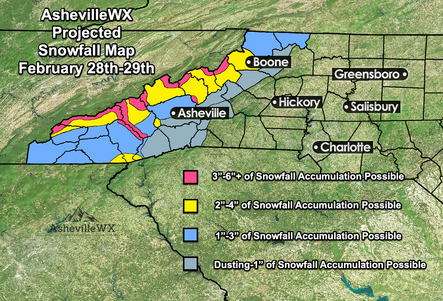
Been a busy day. I like to use the 3km, it is my model of choice with upslope.. but even it is wrong sometimes. Here is my map for this event that I am about to post.
-
2019/2020 Mountains and Foothills Fall/Winter Thread.
Hvward replied to Tyler Penland's topic in Southeastern States
A beautiful sunrise this morning over Alexander! I have around a half inch of accumulation. -
2019/2020 Mountains and Foothills Fall/Winter Thread.
Hvward replied to Tyler Penland's topic in Southeastern States
Got a nice deck coating from this already as a decent band has setup right over me. -
2019/2020 Mountains and Foothills Fall/Winter Thread.
Hvward replied to Tyler Penland's topic in Southeastern States
Loving all the reports! This thread is about to get even more hoping I have a light snow falling at my house in valley along the French Broad in Alexander. -
2019/2020 Mountains and Foothills Fall/Winter Thread.
Hvward replied to Tyler Penland's topic in Southeastern States
No kidding the NAM is extremely bullish. Even has near a half inch at KAVL. -
2019/2020 Mountains and Foothills Fall/Winter Thread.
Hvward replied to Tyler Penland's topic in Southeastern States
Thank you. Shouldn’t let people get to me, but at times it happens. -
2019/2020 Mountains and Foothills Fall/Winter Thread.
Hvward replied to Tyler Penland's topic in Southeastern States
Agreed this is a great NWF setup. -
2019/2020 Mountains and Foothills Fall/Winter Thread.
Hvward replied to Tyler Penland's topic in Southeastern States
Thanks man! Would love to see that deformation feature showing up on the KMRX Radar give everyone a surprise dusting-1” tonight. -
2019/2020 Mountains and Foothills Fall/Winter Thread.
Hvward replied to Tyler Penland's topic in Southeastern States
It’s not a competition man. You need to take a break. -
2019/2020 Mountains and Foothills Fall/Winter Thread.
Hvward replied to Tyler Penland's topic in Southeastern States
But you are petty enough to call an event a bust before it starts. -
2019/2020 Mountains and Foothills Fall/Winter Thread.
Hvward replied to Tyler Penland's topic in Southeastern States
-
2019/2020 Mountains and Foothills Fall/Winter Thread.
Hvward replied to Tyler Penland's topic in Southeastern States
Starting to stick to the grass here at my office in Candler. -
2019/2020 Mountains and Foothills Fall/Winter Thread.
Hvward replied to Tyler Penland's topic in Southeastern States
Sometimes some of you need to step away from the keyboard. Several models showed this dry air from 7-11am and then when heavier precip moves in as the afternoon progresses that dry air disappears and the column goes frozen. Don’t call it a bust just yet. -
2019/2020 Mountains and Foothills Fall/Winter Thread.
Hvward replied to Tyler Penland's topic in Southeastern States
0z EPS average at KAVL now up to 3”. Good to see it finally come around. -
2019/2020 Mountains and Foothills Fall/Winter Thread.
Hvward replied to Tyler Penland's topic in Southeastern States
Most 12z EPS members see some form of accumulating snowfall at KAVL. That’s an increase from this morning. Euro is slowly trying to come around. Will be interesting to see the 18z and 0z. -
2019/2020 Mountains and Foothills Fall/Winter Thread.
Hvward replied to Tyler Penland's topic in Southeastern States
We have been here before fellas/ladies, I.E. December 2017. -
2019/2020 Mountains and Foothills Fall/Winter Thread.
Hvward replied to Tyler Penland's topic in Southeastern States
Hmmmm... interesting. -
2019/2020 Mountains and Foothills Fall/Winter Thread.
Hvward replied to Tyler Penland's topic in Southeastern States
Well KAVL went from .1” of accumulating snow to .7” so that’s a 700% increase in frozen precip. I really just think the Euro is struggling. I have seen it do this before. -
2019/2020 Mountains and Foothills Fall/Winter Thread.
Hvward replied to Tyler Penland's topic in Southeastern States
12z UKMET jumping on board with the strip of precip over WNC. -
2019/2020 Mountains and Foothills Fall/Winter Thread.
Hvward replied to Tyler Penland's topic in Southeastern States
In these type of fast flows I tend to favor gridded models(NAM & GFS) over spectral(Euro) simply because they are better suited to handle the multiple back to back pieces of energy. A spectral model like the Euro divides the atmosphere up into 28 waves across the globe. Having two waves back to back like we are seeing is certainly giving the Euro trouble. It struggled with the last event where there was trailing overrunning precip. It has shown to me a tendency to struggle in these fast flows. The nam with those smaller grid points is better suited to resolve those little details, especially when several vorts are heading our way. We will see at 12z, I am pretty excited to watch model progression today to be honest. -
Wow did we just lose Ryan Newman? Man that was an awful wreck..
-
2019/2020 Mountains and Foothills Fall/Winter Thread.
Hvward replied to Tyler Penland's topic in Southeastern States
18z NAM has precip again oriented in a great fashion for accumulating snow in WNC. -
For the mountains these overrunning events have worked out before. Below 1500’ might struggle with temps though imo.
-
2019/2020 Mountains and Foothills Fall/Winter Thread.
Hvward replied to Tyler Penland's topic in Southeastern States
ICON with a more expansive northern shield of precip on the 12z run. Temps are borderline but I can roll with that look. -
2019/2020 Mountains and Foothills Fall/Winter Thread.
Hvward replied to Tyler Penland's topic in Southeastern States
Yeah I hate to sound clichè but this is going to be one where we will have to see how that precip is blossoming on Wednesday evening and into Thursday. If it’s sets up over N AL and moves to N GA we should be in business. Not a lot to compare this one to with that large expansive high. Usually we don’t have that to work with or one to that extent.