Hvward
-
Posts
3,424 -
Joined
-
Last visited
Content Type
Profiles
Blogs
Forums
American Weather
Media Demo
Store
Gallery
Everything posted by Hvward
-
Well so the long range GFS even brings May snow showers to the valleys next Saturday night. Seriously WTF, I want to plant my tomatoes...
-
Just saw this thread, but GFS shows a stout ULL to begin April like others have stated. Love how we get these setups at the end of winter instead of January...
-

2019/2020 Mountains and Foothills Fall/Winter Thread.
Hvward replied to Tyler Penland's topic in Southeastern States
NAO & AO finally going negative of course. Looks like a long period of cold is going to keep me from starting all the veggies that aren't frost tolerant in my garden. I am hoping we don't get a deep freeze because my strawberries, grapes, blueberries, raspberries, mulberries, and blackberries are all beginning to leaf out. A deep frost now would be devastating to many local farmers. -
2019/2020 Mountains and Foothills Fall/Winter Thread.
Hvward replied to Tyler Penland's topic in Southeastern States
Looks like a mega high pressure will build in late this weekend and provide a strong CAD setup for Sunday into Monday. Could have some mixing around WNC. Both Euro and GFS show the potential. CMC shows a coastal developing with this one, so this has my interest. Will be interested to see where it goes. -
2019/2020 Mountains and Foothills Fall/Winter Thread.
Hvward replied to Tyler Penland's topic in Southeastern States
Starting to see some snow flurries here in North Asheville. -
2019/2020 Mountains and Foothills Fall/Winter Thread.
Hvward replied to Tyler Penland's topic in Southeastern States
18z NAM suite is warm, and most of the precip stays to the South with the initial thump. Backside still looks decent though above 3500'. -
2019/2020 Mountains and Foothills Fall/Winter Thread.
Hvward replied to Tyler Penland's topic in Southeastern States
6z NAM is a tad bit warmer and that makes all of the difference. Let’s see what the 12z runs day, but it’s about time to start leaning on the 3km. -
2019/2020 Mountains and Foothills Fall/Winter Thread.
Hvward replied to Tyler Penland's topic in Southeastern States
Anybody watching the NAM? Another 3”-4” event for Asheville Thursday afternoon and into the night. Not really sure what to think. Absolutely nothing else shows this. Looking at the soundings the column around Asheville goes frozen right as the heavy precip moves in. Weak LP keeps that warm nose down. Cold air source is very meager. That’s the problem here, but NAM says it’s enough. -
2019/2020 Mountains and Foothills Fall/Winter Thread.
Hvward replied to Tyler Penland's topic in Southeastern States
Sorry to hear about your mom buddy. Hope her recovery is quick and painless! -
2019/2020 Mountains and Foothills Fall/Winter Thread.
Hvward replied to Tyler Penland's topic in Southeastern States
Yeah Euro isn’t the King anymore. If the NAM nails this one I will start calling it the king. 12km 18z NAM run just gave KAVL 3.5” on the kuchera maps... has a perfect snow sounding around 11am Thursday. -
2019/2020 Mountains and Foothills Fall/Winter Thread.
Hvward replied to Tyler Penland's topic in Southeastern States
12z Euro is basically a complete whiff for everyone. -
2019/2020 Mountains and Foothills Fall/Winter Thread.
Hvward replied to Tyler Penland's topic in Southeastern States
Could be. Not sure how that trailing precipitation is going to act. All depends on the phase and when it occurs. GFS has it moving in around 8am so I guess we shall see. -
2019/2020 Mountains and Foothills Fall/Winter Thread.
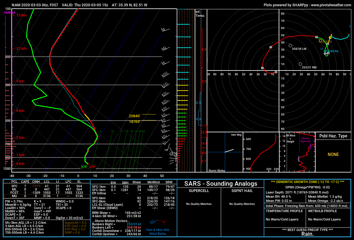
Hvward replied to Tyler Penland's topic in Southeastern States
Here is the sounding from around KAVL early Thursday AM as showers move in per the 12z 12km NAM. 3k NAM is around 2 degrees warmer. Very limited warm nose here which is certainly something to watch.
-
2019/2020 Mountains and Foothills Fall/Winter Thread.
Hvward replied to Tyler Penland's topic in Southeastern States
I am still intrigued with Thursday. Most recent 12km NAM & 3km is limiting that warm nose at 700mb and could allow some sloppy flakes to fall during heavy precipitation bursts. Then the 12km has a bit of deformation action on the backside Thursday night. Still several details need to be resolved and 1-2 degrees here is going to make a huge difference for valley locations. Continuing to watch soundings. Elevations above 3500' should see 2"-4". -
2019/2020 Mountains and Foothills Fall/Winter Thread.
Hvward replied to Tyler Penland's topic in Southeastern States
Give me 3 more hybrid clippers and I’ll be satisfied. Lol -
2019/2020 Mountains and Foothills Fall/Winter Thread.
Hvward replied to Tyler Penland's topic in Southeastern States
At Hr 84 the column is nearly frozen. Wet bulb would probably slow for moisture to fall is snow. Several EPS members also have the chance for a dusting or so either from a front end thump, or a backside push of moisture. Several possibilities here. -
2019/2020 Mountains and Foothills Fall/Winter Thread.
Hvward replied to Tyler Penland's topic in Southeastern States
Lots of details still to be figured out with this Thursday into Friday system. NAM has a phased solution that hammers the High Country. Would love to see that high pressure trend to 1030mb. -
2019/2020 Mountains and Foothills Fall/Winter Thread.
Hvward replied to Tyler Penland's topic in Southeastern States
12z GFS has snow showers Thursday am for SW WNC as that front moves along the Gulf Coast. If we could get this high pressure to build in a bit more we could have another small event for the area. -
2019/2020 Mountains and Foothills Fall/Winter Thread.
Hvward replied to Tyler Penland's topic in Southeastern States
Here were a few time-lapses as the heavy band moved through this morning. -
2019/2020 Mountains and Foothills Fall/Winter Thread.
Hvward replied to Tyler Penland's topic in Southeastern States
Thank you! One band can make or break a forecast here in the mountains of WNC. -
2019/2020 Mountains and Foothills Fall/Winter Thread.
Hvward replied to Tyler Penland's topic in Southeastern States
Setup for Friday & into Saturday of next week is not terrible on the Canadian and Euro. Lots of players on the field and the Euro and Canadian are nowhere close to each other, but each solution pans out to snowfall in the High Country. This timeframe has my attention, lets see what the models do with building in a high pressure. The overall progression is very slow with the waves, so imo an increased chance for phasing to occur. -
2019/2020 Mountains and Foothills Fall/Winter Thread.
Hvward replied to Tyler Penland's topic in Southeastern States
Here is a radar grab of that band that brought most of the French Broad River Valley snow this morning. -
2019/2020 Mountains and Foothills Fall/Winter Thread.
Hvward replied to Tyler Penland's topic in Southeastern States
-
2019/2020 Mountains and Foothills Fall/Winter Thread.
Hvward replied to Tyler Penland's topic in Southeastern States
Got about 2.5” at my house here in Alexander from that nice band that setup over us for several hours. Best snow of the season for the French Broad River Valley so far. -
2019/2020 Mountains and Foothills Fall/Winter Thread.
Hvward replied to Tyler Penland's topic in Southeastern States
Getting some nice bursts of heavy snow in North Asheville. Trying to dig out a foundation so not as fun as it could be. Shortwave tonight should provide another shot for accumulation for many.