Hvward
-
Posts
3,424 -
Joined
-
Last visited
Content Type
Profiles
Blogs
Forums
American Weather
Media Demo
Store
Gallery
Everything posted by Hvward
-
Interesting setup coming here on Friday and into next Saturday. Still looking for some cohesiveness among models, but all three major models show some form of snowfall for many around WNC during the mentioned time frame. The EPS is actually very bullish for this event. Its all going to depend on that ULL capturing the surface low as it transfers. One of these situations is bound to work out in our favor. Eventually if we get enough ULL's to come through one will catch a surface low and we will be in business. Main takeaway is that a -NAO is poised to develop and that will significantly increase our chances for a low to stall as it transfers. From what I see, we will have several chances for ULLs to move through with surface lows in favorable positions for a SE snow over the next 3 weeks. Should be some fun times of tracking!
-
Interesting trends on the GFS with the ULL capturing the LP as it transfers from the Gulf to the Atlantic. The 12z just spit out a couple of hours of snow showers for Sunday. Something to watch... especially for the higher elevations.
-
One more shot from my garden and the house above. Merry Christmas everyone!
-
Checking in with 6” here in the Alexander Community! Still snowing.
-
Nam 3km keeps increasing totals up to the event. Thats always a good sign. Going with 2"-4" for most of Buncombe.
-
Several models showing the flow switching from a WNW to a true NW late in the day on Chirstmas with a strong batch of moisture moving off of the Great Lakes. With temps as cold as they are projected, many will see snow flurries and showers throughout the day on Christmas and into the evening hours.
-
Yeah the dendritic growth zone is going to be between 4500’-7000’ on Xmas Morning. The flow could continue on into the morning on For many. Snow showers will make themselves with the growth zone that low.
-
Nice model spread regarding snowfall on the overnight models. Euro with the lowest for KAVL at 1” with GFS being the higher end 3”+. I hate forecasting these type fronts, but it seems the changeover could happen just as the sun is setting on Christmas Eve night. Timing is going to be key, and whatever falls will be on the ground for Christmas morning IMO.
-
Both 18z Nam 12km & 18z Nam 3km show precipitation falling as snow early Sunday morning. This one could be sneaky. Lets see if the column of air is actually that cold and continues to show up over the next few runs, but something to watch. Nam 3km had an inch of accumulation at KAVL.
-
3 Chances for snow coming up in the High Country over the next week. Sunday morning could be very interesting for many with the RGEM showing light icing being possible along the Escarpment, and snowfall above 3500'. Warm nose will be weak with this meager front. Then Monday night into Tuesday another wave will move through before the polar front passes by on Christmas. Lots to track here for sure!
-
18z GFS with a better phase. NW trend come on down!
-
Yep 12z Euro with a similar look to the 0z. Many times I’ve seen these overrunning signatures that show up like this turning into a decent thump where some see 3”+ along the Escarpment.
-
Sunday night through Tuesday is starting to grab my attention. Possible some overrunning precipitation. Lots going on at the 500mb level so I think we have a long way to go before we know how this one will unfold. Models are showing a deep Gulf Low shooting up and interacting with a ULL. Euro has what is very close to a snow sounding Monday evening. Column is also very saturated. All models show the ULL and the GL, it’s just a matter of how close they get to each other, and if the ULL can capture the GL.
-
Already snowfall on the ground in Banner Elk. It would be worth it. Check my live camera up there. https://www.ashevillewx.com/banner-elk-live-camera
-
Hoping that the ULL can bring everyone a nice snow shower or two on Monday night or Tuesday morning. Looking at the second storm that will affect WNC late this week and into the weekend, this one is really interesting. There is really no model agreement at this point as to the timing on when the ULL will move through. There is also a Gulf Low that is throwing another wrench in the gears. Overnight Euro shows WNC being able to take advantage of the exiting 50/50 low to our Northeast, and some overrunning precipitation produces scattered snow showers Friday Morning. Then as the ULL begins to capture the GL and deepen, a deformation feature develops on the backside and hammers WNC with frozen precipitation as Omega crashes aloft. This all happens with temps that are very borderline, but heavy precip seems to overcome on the 0z model run. In fact the control on the 0z EPS gave WNC 5" of snow. The GFS is similar with the deepening of the low pressure, but is slower with the ULL and the GL turns into a Noreaster. It seems there is a window of possibility for snow Friday into Saturday if the ULL can capture the low in the Gulf. CMC is slower with the ULL as well right now, so we will see. What does appear likely is another thump of snow for those above 3500'. This will be a good week for high elevation folk. Enjoy!
-
Looking forward to the pictures man!
-
Trends are away from anything meaningful in the valleys(over 1"). High elevations are going to get a couple of inches from the first NWF Monday night, but models are holding back that second piece of energy. Looks like more of a Friday night-Saturday time frame if anything were to happen. Still a lot can change, but these are not trends that favor a strong southeast snowstorm unfortunately.
-
Yeah very close with that first storm. Phases just a little too late. Main takeaway is that the timeframe from Dec 1-8th looks conducive for some form of a winter storm.
-
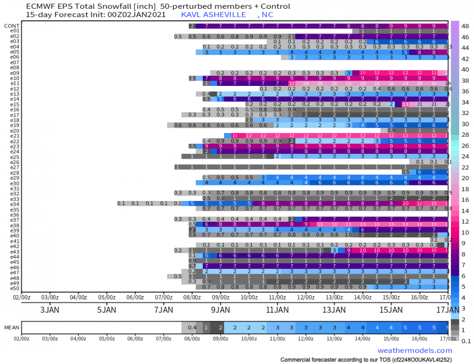
12z EPS has some big dogs. Looks to me like a decent window for some sort of phasing to occur. Still a ton of details to be hammered out, but this is not a bad look 7-9 days out.
-
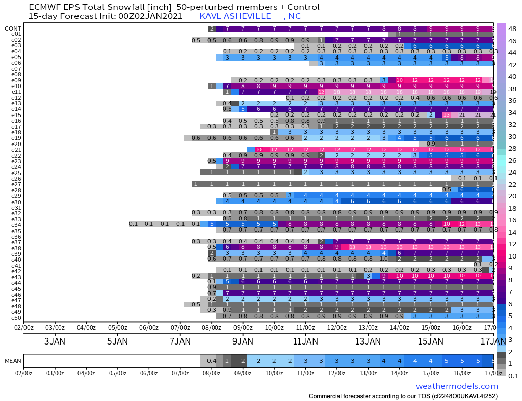
EPS snow signal getting strong each run for KAVL. That’s a measure I like to watch this far out from the possibility of wintery weather.
-
Yeah was coming here to post about that. Pattern change looks almost certain now around the beginning of Dec with both the GFS & Euro showing the potential for some energy to move through the South. Glad to finally have something to track..
-
Some very strong winds showing up on most models Thursday afternoon around WNC. Euro latched on to this solution yesterday and it appears that all other have fallen suite. Looks like the core of Zeta moves right through WNC. Anyways, batten down the hatches!
-
Got a few shots from Roan this morning. https://www.ashevillewx.com/weatherupdate/2020/5/8/may-snow-coats-nc-high-country-photo-gallery
-
Buckethead and I have been trying to get a webcam up at the Country Club in Wolf Laurel. I have the whole setup, just need a commitment. Would be a moving 4-5 view 1080HD camera that operates year round. Going to send some follow up emails about that, seemed that it had really good potential at one point in time.
-
I slipped on ice on my deck this morning. I am currently over May. Frosted at my house this morning... 2200’ and a mile from the French Broad. My thermometer said 31.