

andyhb
-
Posts
19,888 -
Joined
-
Last visited
Content Type
Profiles
Blogs
Forums
American Weather
Media Demo
Store
Gallery
Everything posted by andyhb
-

Devastating tornado strikes Joplin, Missouri
andyhb replied to Hoosier's topic in Weather Forecasting and Discussion
It could be a satellite rotation off of the main circulation, I believe the El Reno tornado had something similar at one point. It could also just be a cloud formation if it wasn't rotating (a bit hard to tell in that video). The power flash at the end reminds me of one of the shots of the 5/3/99 tornado in Moore from a helicopter. -
I believe you are referring to this (insane motion):
-
And this is the shear they would've had access to if they had fired in that area:
-
Let's play "where's the tornado" with that volume scan. And here's the 4 km NAM image that Hoosier was referring to (this had 2000 J/kg of CAPE to Kokomo), this would've been something else...
-
Indianapolis would've been in trouble (as would Kokomo, Bloomington, , I believe Dayton would've been in far greater trouble as well. I remember you pulled some ridiculous sounding from there a couple of days out, I'll see if I can dig it up. Ah yes, here it is...an EHI of 10.5 on March 2nd?
-
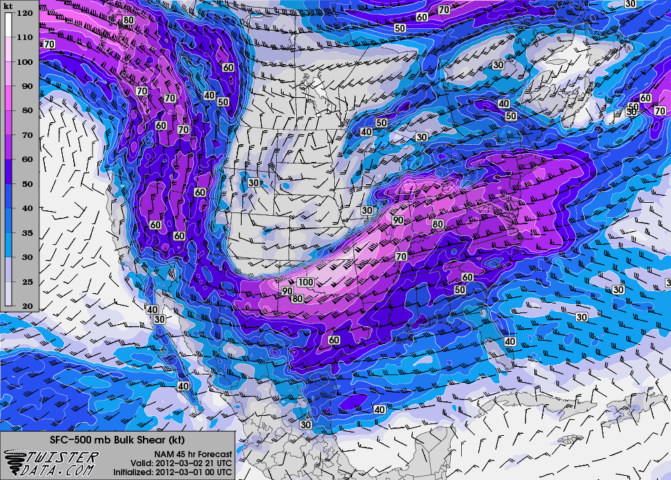
One thing that can be appreciated is just how lucky the big cities in the outbreak zone got on this day. Louisville, Lexington, the Cincinnati/Dayton metro and Nashville were all well under the gun with this event and the big storms decided to play hopscotch around them. Not to mention the threat down south didn't materialize as it could have later on with the gradually veering low level winds. There was a strong tornado in GA northwest of Atlanta and in Central AL (northern AL and the Chattanooga area got hit in the morning), but there could've been a secondary outbreak down there had things been tweaked just a bit. 0-6 km bulk shear graphic I posted from the 00z March 1st NAM.
-
As the title suggests, today is the one year anniversary of the most significant tornado event to affect the Ohio Valley region in quite sometime (likely at least since the 6/2/90 outbreak) and one of the most impressive severe weather events in Early March on record in the United States, just two days after a deadly and destructive tornado struck Harrisburg, IL on the morning of Feb 29th. Towns such as New Pekin and Henryville, IN, West Liberty and Salyersville, KY and Moscow, OH suffered severe damage from strong/violent and fast moving tornadoes. This day also marked only the 3rd time since 1985 that two separate tornadoes killed 10 or more people (4/27/11 and 2/5/08 being the others). Violent tornado moving into Henryville, IN on Louisville, KY radar: The New Pekin/Henryville tornado: West Liberty, KY tornado on Jackson, KY radar prior to reaching the town: MCD Issued as the outbreak was really going on in Eastern KY:
-
Well there was one in April 2010 as well (Yazoo City).
-
The April 27th, 2011 outbreak.
-
Increased storminess for last week of January
andyhb commented on OKpowdah's blog entry in Tropospheric Torrent
Many of the models and quite a few ensemble members have that second trough/disturbance diving into the West around the D10 period. -
Alaska/Western Canada obs and discussion
andyhb replied to patrick7032's topic in Central/Western States
Snowed in Tokyo with that thing. -
Historic Tornado Outbreak April 27, 2011
andyhb replied to CUmet's topic in Weather Forecasting and Discussion
Screen cap of the Phil Campbell tornado going through the city/around that area, taken from the Country Road 71/Mon Dye road area on the east side of town near Little Bear Creek, looking back WNW towards the wedge tornado, likely with EF5 damage occurring right as this shot was taken. -
Alaska/Western Canada obs and discussion
andyhb replied to patrick7032's topic in Central/Western States
Got TSRA right now. -
Alaska/Western Canada obs and discussion
andyhb replied to patrick7032's topic in Central/Western States
Pacific NW might be in for a decent storm on Saturday, The 00z GFS, GGEM and NAM all get a ~980 mb cyclone rotating out of the large west coast trough with strong southeasterly winds around the coast/perhaps inland depending how the LLJ dynamics shape up (although a bit more of a southern nudge would be a more impressive scenario), in addition to fairly solid rainfall amounts, will check the Euro momentarily to see if trends south a bit. GGEM and GFS also have a second system around the 120 hr period, with the GGEM being much more impressive (although this might be suspicious considering the GGEM's tendency to overdue sfc cyclogenesis, the UL jet feeding this system is stronger than the one on Saturday). Edit, Euro, although stronger with the Saturday system, is further north. -
Alaska/Western Canada obs and discussion
andyhb replied to patrick7032's topic in Central/Western States
Textbook cyclogenesis... -
Alaska/Western Canada obs and discussion
andyhb replied to patrick7032's topic in Central/Western States
Spectacular... -
Alaska/Western Canada obs and discussion
andyhb replied to patrick7032's topic in Central/Western States
Great googly moogly... -
Alaska/Western Canada obs and discussion
andyhb replied to patrick7032's topic in Central/Western States
Just a sick H5 vort max associated with this thing... -
Alaska/Western Canada obs and discussion
andyhb replied to patrick7032's topic in Central/Western States
Lord that is a beautiful presentation on the RH map, about as classic as it gets. -
Alaska/Western Canada obs and discussion
andyhb replied to patrick7032's topic in Central/Western States
Very strong system (sub 960 mb) at 96 hrs from the OPC in the Gulf of Alaska...this may have impacts down the road for the troughing pattern over the lower 48. -
Alaska/Western Canada obs and discussion
andyhb replied to patrick7032's topic in Central/Western States
Lord knows above all the drama and whatnot, Deadliest Catch has taught me something about Bering Sea weather (i.e. it's violent on an almost regular basis, sort of like the Southern Ocean). -
Alaska/Western Canada obs and discussion
andyhb replied to patrick7032's topic in Central/Western States
Man, imagine if we had troughs like those swinging across the lower 48... Also, I think Josh should consider chasing storms up here while the hurricane season is quiet. -
Devastating tornado strikes Joplin, Missouri
andyhb replied to Hoosier's topic in Weather Forecasting and Discussion
I do think the communication may lead to a false sense of security in a way, although I think people's overall idea that "It'll never happen to me" seems to override all other factors in many of these cases. -
Devastating tornado strikes Joplin, Missouri
andyhb replied to Hoosier's topic in Weather Forecasting and Discussion
Candlestick Park tornado killed 57, just FYI. -
Historic Tornado Outbreak April 27, 2011
andyhb replied to CUmet's topic in Weather Forecasting and Discussion
So I just listened to that Hackleburg/Phil Campbell video with volume on full blast...holy ****