andyhb
-
Posts
20,454 -
Joined
-
Last visited
Content Type
Profiles
Blogs
Forums
American Weather
Media Demo
Store
Gallery
Everything posted by andyhb
-

Dec 16-17 Storm OBS Thread
andyhb replied to BuffaloWeather's topic in Upstate New York/Pennsylvania
NWS BGM met. -
Just lol @ sustaining 0.35-0.4" QPF/hr rates in 15˚F temperatures.

-
Dec 16-17 Storm OBS Thread
andyhb replied to BuffaloWeather's topic in Upstate New York/Pennsylvania
Oh no biggie just 1.11" QPF in 3 hours with temperatures of 15˚F.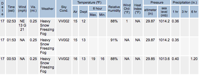
-
Only thing I can compare it to is the band with the Pi Day blizzard in March 2017 or the one with the Feb 2013 blizzard in CT (and that was significantly shorter duration).
-
Dec 16-17 Storm OBS Thread
andyhb replied to BuffaloWeather's topic in Upstate New York/Pennsylvania
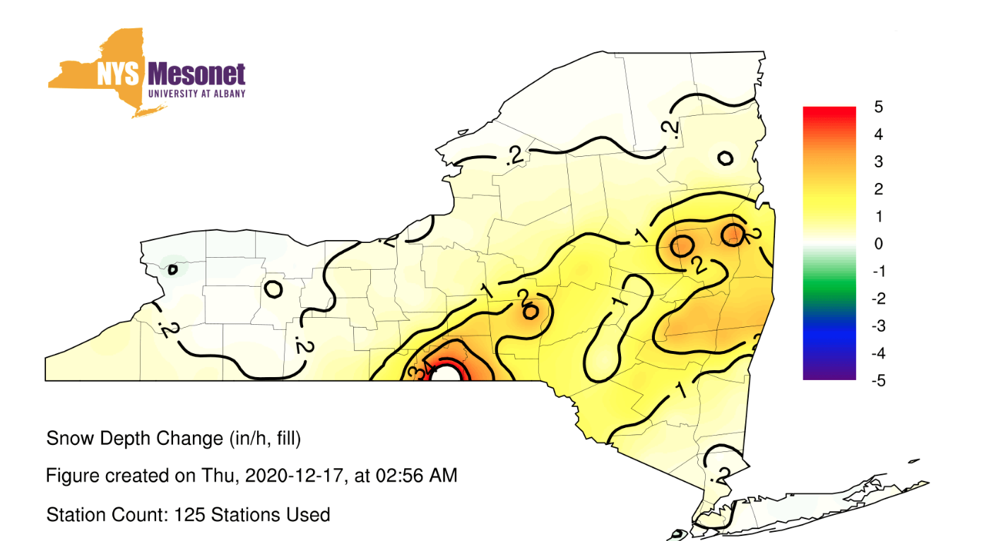
When your snowfall rates literally break the scale for the NY Mesonet page...
-
Looks like the snowfall rates at BGM are literally off the scale of the NY Mesonet site.

-
Dec 16-17 Storm OBS Thread
andyhb replied to BuffaloWeather's topic in Upstate New York/Pennsylvania
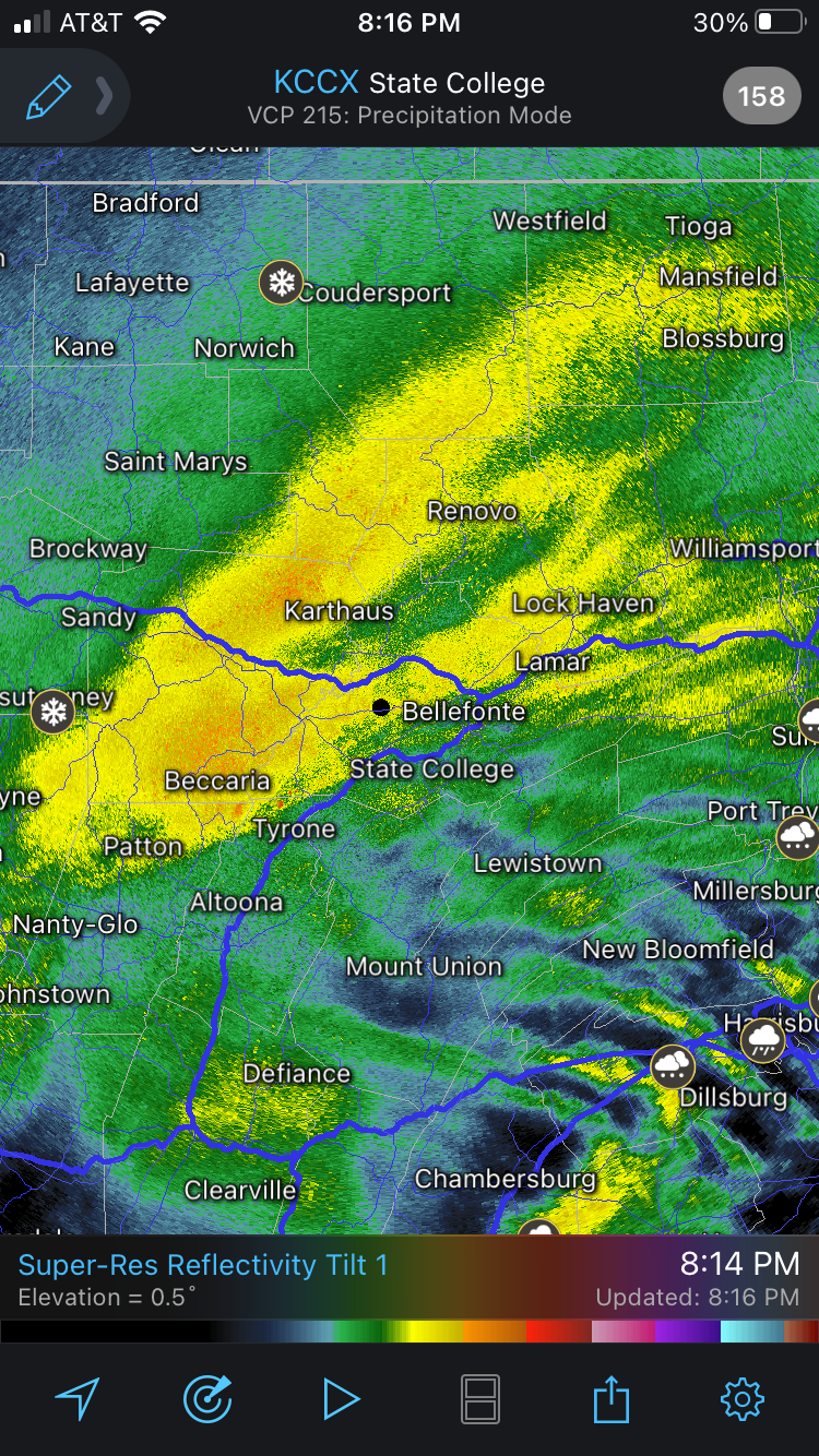
Somehow that band has actually widened and intensified in the past 60-90 mins on radar. Just incredible frontogenetic forcing with great vertical velocities in the DGZ intersecting with a nearly ideal temperature profile for big rates. -
Dec 16-17 Storm OBS Thread
andyhb replied to BuffaloWeather's topic in Upstate New York/Pennsylvania
March 1888 would like to have a word. -
Here's that observation I was referencing.
-
NWS employees are reporting >5"/hr rates at Binghamton right now.
-
Dec 16-17 Storm OBS Thread
andyhb replied to BuffaloWeather's topic in Upstate New York/Pennsylvania
KBGM 170553Z AUTO 1/4SM +SN FZFG VV002 M09/M11 A2985 RMK AO2 TWR VIS 3/4 SLP136 P0040 60120 T10891106 11072 21089 58023 RVRNO Unreal 06z observations at Binghamton. 0.4" QPF in an hour. -
December 16 2020 CTP Snowstorm Disco and Obs
andyhb replied to pasnownut's topic in Upstate New York/Pennsylvania
That is just a monster band. Could see some 30” jackpots where it pivots.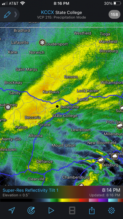
-
Curious if we see an uptick in severe weather potential later in winter given some of the parallels to years like 2007-08 (which saw significant tornado outbreaks in Jan-Feb including a historic one Feb 5-6) and 2011-12, which saw several significant events in Jan-March, including the back to back Leap Day and major 3/2 tornado events. Seems like general consensus for a number of forecasts I’ve seen is for western troughing/eastern ridging to become more prevalent Jan-Feb, which would favor that. We also have a significant drought across much of the SW, which is liable to yield enhanced capping due to EML advection, which is often a caveat in winter given the likelihood of strongly-forced synoptic scale waves.
-
It was posted on TWN as well I think.
-
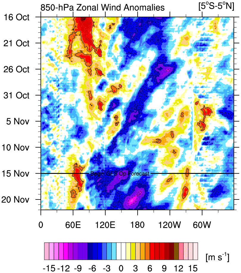
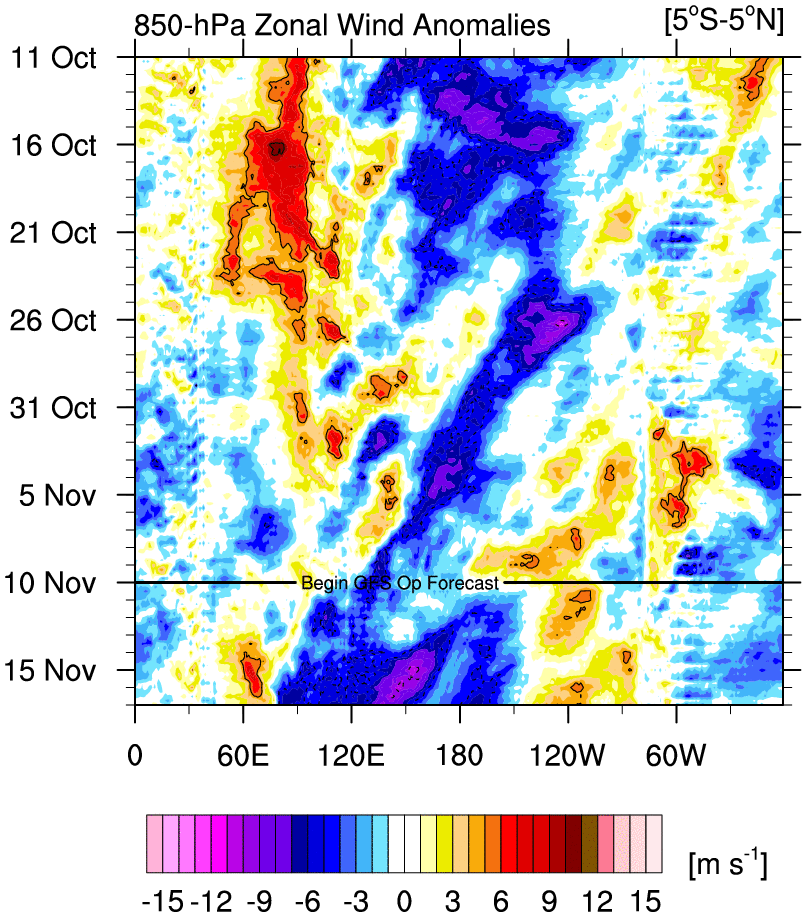
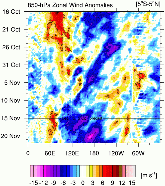
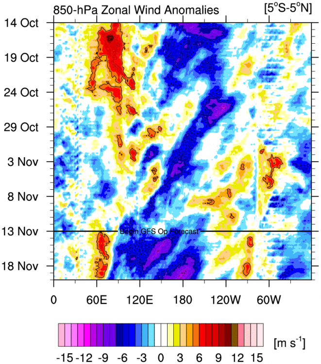
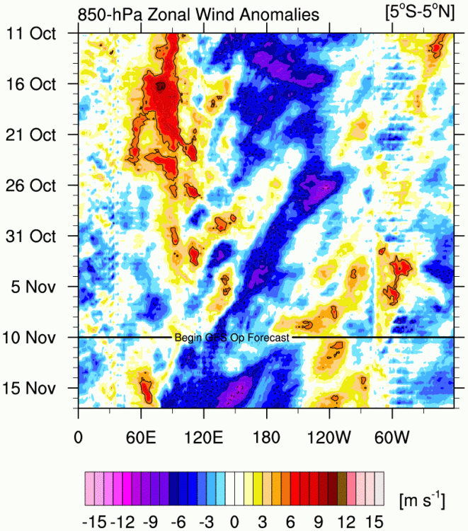
Excuse the repeated Hovmoller posts, but that would be the strongest surge of anomalous easterlies yet during this Niña event.
-
Toronto Island gusted to 73 mph, Niagara Airport gusted to 87 mph. This is a major wind event for the Eastern Lakes.
-
Not really a 12/1/18 setup dynamics wise, more like 11/17/13 tbh. This would be a large outbreak with better thermos.
-
Going to be quite the event for the west-east oriented lakes tomorrow. Erie is the one that should be most favorable for long fetch.
-
Looks like trades are fixing to ramp up again following a general lull at the beginning of November, but it also looks like the Nina standing wave might re-establish a bit westward of where it was previously. More cooling of the western regions as opposed to the eastern regions?
-
Storm on Sunday could be quite the wind maker on the Lakes.
-
Can see the intraseasonal signal being superimposed on the trades east of the dateline right now in the Hovmoller diagrams.
-
That is nuts. Seems to be wave-like features propagating outward from the eye/eyewall region as well.
-
That is one heck of a wind field on KMOB, lots of >100 kt outbounds not too far off the deck. Going to be an impressive inland wind event for MS/AL.
-
These are some big gusts coming out of where it made landfall. Also reports of significant structural damage in the area.
-
Earlier microwave scans were setting this table. Not going to have very much time for weakening near landfall if this continues to blow up in the next 12 hours.