andyhb
-
Posts
19,888 -
Joined
-
Last visited
Content Type
Profiles
Blogs
Forums
American Weather
Media Demo
Store
Gallery
Everything posted by andyhb
-
Definitely a few similarities with the setup that yielded the deadly TN tornadoes on 3/3. Strong westerly flow aloft with similar hodograph structure and I'm going to bet that the NAM/NAM 3 km are too cold at the surface. Any southerly component to the surface wind will yield large 0-1 km SRH when your 850 mb jet is 50 kts out of the WSW.
-
JISAO PDO is no longer being updated. Also, the +AO has reached an all time record daily value at 6.34, surpassing 2/26/90 at 5.91.
-

MO/KS/AR/OK 2019-2020 Winter Wonderland Discussion
andyhb replied to JoMo's topic in Central/Western States
Getting increasingly concerned that the strongest low-mid level FGEN and vertical ascent may set up right over the I-44 corridor in OK and N TX with this. Someone who stays cold enough is going to see 12-18”, which, for here, is crippling. With that said, the 3 km NAM seems stubbornly persistent in its idea of really suffocating the band before anything really gets going. -
Been watching some of the Twitter feed for this and holy crap. Probably one of the most severe winter storms for one of the metros in Atlantic Canada in the past 30 years, along with White Juan for Halifax in 2004.
-
Summed up some thoughts here. This is troublesome to say the least. Not to mention the 00z HRRR coming out with essentially a tornado outbreak near the I-35 corridor with numerous semi-discrete supercells.
-
Pretty impressed by the parameter space being indicated across the model suite on this one for both days. The NAM is likely underdoing temperatures at least somewhat, which renders a fairly substantial amount of instability for this time of year across essentially the full extent of the warm sector. Dewpoints today have been either on or ahead of schedule across the Texas Gulf Coast north to the Red River. The progged low level shear and hodograph size on Friday night through Saturday is, simply put, extreme. Could be approaching or exceeding all time record 850 mb flow readings on Saturday across multiple stations. I've also seen a few soundings pulled from S of DFW tomorrow that look more April/May like in terms of thermodynamic and shear combinations. Basically everywhere from I-35 east and I-40 south ought to be prepared for this. Storm mode is, as mentioned, the biggest question. I get the feeling it will be both a very strong QLCS full of embedded LEWPs, bows, and mesovortices and a few discrete cells out ahead here or there. I'm also concerned with the evolution of the shear vectors on Saturday becoming more normal to the front, and that we may see some downscale evolution of the QLCS into semi-discrete storms, which would have a 70+ kt LLJ to work with and a decent amount of low level buoyancy.
-
As mentioned above, I’m pretty impressed with the forecasted EML on Friday. Several point soundings indicate 700-500 mb lapse rates exceeding 8 C/km and a pretty notable cap early on which could help limit junk convection. It remains to be seen how the wind fields evolve, but just seeing that capping/steep lapse rates in conjunction with a seasonably moist warm sector with mid-upper 60s dewpoints has me raising eyebrows. I also have concerns about overnight Friday into Saturday morning, as the trough swings negative tilt and the wind fields really ramp up across the Lower Mississippi and Tennessee Valleys. That actually may end up being the best juxtaposition of strong low level shear and rich low level moisture, but obviously there are still changes ahead. Overnight sig severe and Dixie is tailor made in the cold season (see 12/16/19 and 1/21-22/2017 for a couple of recent examples).
-
Euro/EPS have been getting stronger with the cold dumping into the NW during this period as well, more of an Arctic source region than a Pacific one.
-
That was a very 2008-like 00z Euro run. Probably a couple of severe wx events in the SE and a major winter storm with the first for Chicago/GRR. Big ice storm for DTX/Ontario.
-
As is tradition, let's give our calls for how active the first tornado season of the decade will be. Looks like we'll be heading towards spring with weak positive ENSO and roughly neutral PDO, in addition to a lack of drought over most of the area east of the Rockies. I have a feeling like we may see another A/AA season given some of these climate states, but obviously sub-seasonal activity will again be key. Will have more analysis later. Number of tornadoes: 1310 First High Risk: 4/18
-
At this point I’m just looking for an email to recover my password.
-
Ditto this situation.
-
Naturally we get a TS and the first thing that comes up is Sandy comparisons.
-
That is an impressive shortwave coming through the S Plains for the end of June on Sunday. Setup looks more May-like synoptically.
-
2019 Short/Medium Range Severe Weather Thread
andyhb replied to snowlover2's topic in Lakes/Ohio Valley
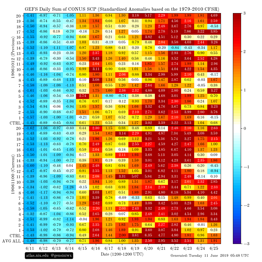
Yeah this is a pretty wicked signal for rising severe potential past mid month somewhere from the GEFS (standardized anomalies of SCP aggregation).
-
Central/Western Medium-Long Range Discussion
andyhb replied to andyhb's topic in Central/Western States
Early June has been very quiet for most of the 2010s, the exception being 2010 itself. I definitely think the latter part of next week will have a chance beyond the amplification of the ULL near the Great Lakes. There is a strong signal in the GEFS for at least some activity in that period (and there has been for awhile), and note that the GEFS SCP chiclets on Gensini's website are anomaly based, rather than using raw count, so it gives a better idea of elevated activity relative to climo. Signal on the EPS is rather nebulous, but I wouldn't expect a really large signal in the heights at this point since it looks to be more centered around subtle disturbances in the flow. -
Going to hit Georgetown shortly if it stays down.
-
What in the hell is going on out there.
-
That supercell crossing Chesapeake Bay right now is a beast.
- 2,802 replies
-
- 1
-

-
- severe
- thunderstorms
- (and 4 more)
-
2019 Short/Medium Range Severe Weather Thread
andyhb replied to snowlover2's topic in Lakes/Ohio Valley
Need to start paying attention to Sunday in the Upper Ohio Valley. Incredible soundings for the region coming off the 00z NAM/NAM 3 km and both of them have a string of supercells/bow echoes in the area. -
2019 Short/Medium Range Severe Weather Thread
andyhb replied to snowlover2's topic in Lakes/Ohio Valley
Still quite far out, but the ensemble guidance is honing in on a the potential for a large longwave trough moving into the Central US in the middle of next week and it would certainly have severe potential, possibly into the reaches of this sub-forum. There have been some pretty nutty operational runs the last couple of days for that timeframe, and the CFS chiclets also have had a signal for the 4/16-4/19 period for awhile now. Fits with a -AAM tendency over the next week and a ridge amplification N of Hawaii. -
Spring/Summer 2019 Complaint/Banter Thread
andyhb replied to HillsdaleMIWeather's topic in Lakes/Ohio Valley
I think the snow maps from the 12z Euro need to be posted for posterity's sake. That is just ungodly what it does for IA/WI/MI. -
Spring/Summer 2019 Complaint/Banter Thread
andyhb replied to HillsdaleMIWeather's topic in Lakes/Ohio Valley
We turn the calendar to April and a massive -NAO shows up. Oy f***ing vey. -
Spring/Summer 2019 Complaint/Banter Thread
andyhb replied to HillsdaleMIWeather's topic in Lakes/Ohio Valley
Well that 12z Euro run was a disaster to say the least. -
Spring/Summer 2019 Complaint/Banter Thread
andyhb replied to HillsdaleMIWeather's topic in Lakes/Ohio Valley
This is why we need severe wx to blow all the pollen away.