andyhb
-
Posts
19,910 -
Joined
-
Last visited
Content Type
Profiles
Blogs
Forums
American Weather
Media Demo
Store
Gallery
Everything posted by andyhb
-
 Reminder to use the FRAM estimates available on PivotalWx for ice accretion and not ZR QPF. It's a much better (and scientifically sound) method for estimating/forecasting icing events.
 -
Michigan: where exciting weather goes to die.
- 856 replies
-
- 10
-

-

-

-

-
Here they are.
-
Someone needs to dig up the baro post in @Thundersnow12's sig for nostalgic purposes, since I'm pretty sure it was about now 11 years ago that things started to go to hell in a hand basket around these parts.
-
I have a bad feeling about I-44 particularly in OK with this one. Setup screams either a big sleet event with snow/ZR mixed in, or a nasty ice storm.
-
Ready 2 b buried?
-
Thought the same thing looking at that. If we get that shortwave to amplify just a bit more and eject more intact, not only does the potential for a blizzard go up, but I could see jackpots approaching 2 feet from that wave alone given how moisture logged this thing is. Effectively, this thing is basically two storms in one.
-
N IN and NW OH absolutely destroyed.
-
18z GFS is going to be an absolute crush job. Wider swath of large accumulations with the lead wave and the second one is coming in deeper.
-
Northern stream looks like it's going to be too dominant on the Euro.
-
St. Louis and Indy get absolutely shellacked by the CMC, I-70 special.
-
Did places in N RI and SE MA legit get 4 feet in 1978 or is that just urban legend? Most maps I see from that are around 3 feet or so in the jackpot zones.
-
QPF output on some of these models is nutty. Not very often where you talk about such a moisture laden system that lasts awhile, but this could be it.
-
Too sheared out.
-
This is looking like a top 5er potentially for the general Boston area.
-
Granted for storms that have no chance of slipping out to sea, the SSTAs will obviously be a positive factor in terms of intensification, but that might not be the case for borderline events or those that suddenly have double low configs.
-
So when do we start the conversation about what would happen if the SSTAs weren't so warm re: excess convection dragging the surface response east?
-
I believe the dynamic snow ratio (attempts to account for dendrite fracturing due to the wind) from Weathernerds might be a good reference here.
-
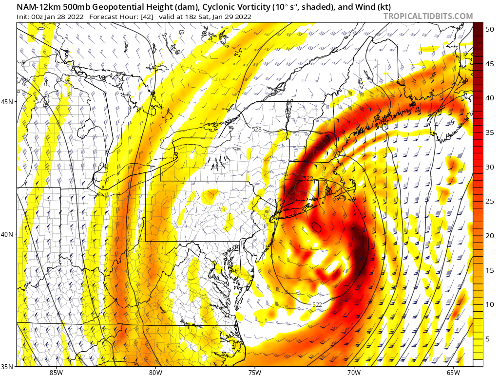
Put this 500 mb plot in some sort of new Kocin-Uccellini textbook because that is just about perfect.

-
Deep, saturated dendritic (snow) growth zone with large amounts of upward motion centered within it from the intense mid-level frontogenesis, cold temperatures closer to the surface -> very, very high snowfall rates. Wind will cut down somewhat, but you'd be easily talking 3-4"+/hr rates with that.
-
Ok what in the actual f*ck...
-
I'd hesitate from declaring this with a potential sub-975 mb low interacting with astronomical high tides.
-
What even is this thread title?
-
Also you don't just see 4-5"/hr rates in a city of that size very often (not counting LES).