

andyhb
-
Posts
19,888 -
Joined
-
Last visited
Content Type
Profiles
Blogs
Forums
American Weather
Media Demo
Store
Gallery
Everything posted by andyhb
-
https://x.com/TikovonlaberWX/status/1733624586376233148?s=20 In Gallatin.
-
Supercell west of Nashville is looking prime to produce a strong tornado.
-
https://x.com/NC5_LelanStatom/status/1733584838408425710?s=20
-
Apparently the Robinson IL/Sullivan IN tornado from this event is being re-evaluated by NWS Lincoln, partly due to flooding that prevented surveys of certain portions of the track. Wonder if we get an upgrade to EF4 here.

-
10 years since 11/17/2013 today.
-
https://x.com/ClintonHaVi/status/1717062382290186357?s=20 Conditions getting very nasty via this video.
-
Acapulco does have a radar, but it is currently out of service and has been for sometime. They have had major upheaval in that city in the 21st Century.
-
That is one of the all time NHC discussions.
-
It's a Cat 5 per NHC...
-
Acapulco is in trouble from this one if it continues to outpace intensity forecasts/doesn't fall apart on approach. Current official track essentially puts the RFQ right over the bay/city. Some Pauline '97 vibes with how it parallels the coast for a bit too, which produced extreme flooding in Guerrero.
-
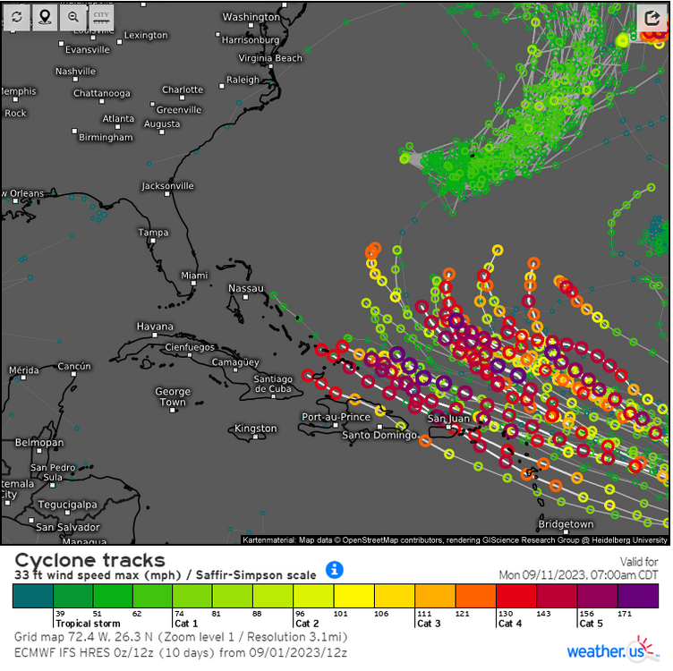
12z guidance, particularly the Euro, are not painting a pretty picture for 94L regarding the Antilles. MDR upper air pattern is amazingly favorable for it this late in the season in an El Nino year, plenty of heat content/warm SSTs to work with as well.
-
https://twitter.com/seekndstroy7809/status/1699937840262512887?s=46&t=lVM9qxUr3uVWV5VH8ESp6g This may be a first.
-
The new HAFS-A is literal weenie bait, gets down to 900 mb with 178 kt (205 mph) sustained winds in the next 36 hours. That would break the Atlantic record for wind speed by 15 mph (Allen, 1980).
-
Getting even better.
-
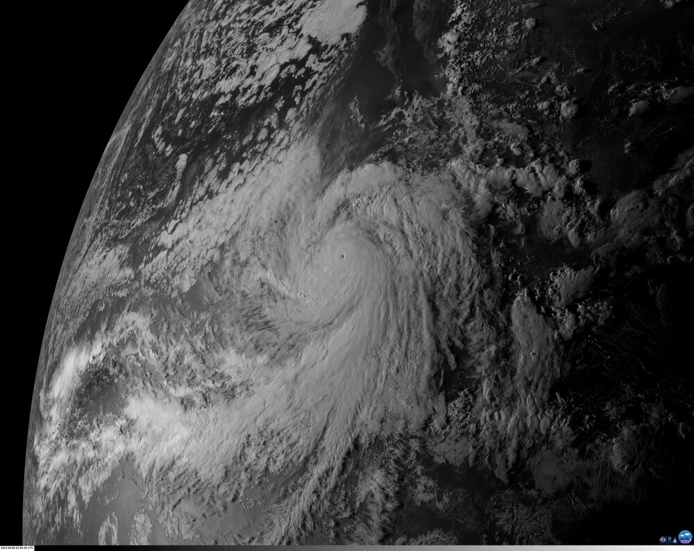
Basically a perfectly formed inner core on the latest microwave satellite imagery. This is likely going to be pushing Cat 5 in this first recon pass.
-
Hurricane Jova is a monster right now. Current advisory has it at 130 mph/953 mb, but I guarantee it is considerably stronger.
-
Potential Northeast storms are so annoying to track, most notably due to the constant influx of unnecessary 1938 comparisons that are bound to arise.
-
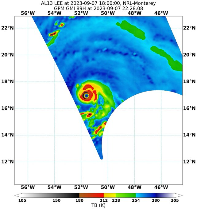
A lot of very strong members with potential Lee. Looks like a potential long tracker/high ACE producer at minimum. Not an auto-fish look either.
-
00z NAM 3 km is absolutely ridiculous rainfall wise and particularly in the orographic enhancement areas of the San Bernardino and San Jacinto mountains. Those totals (10-20” in less than 3 days) would be catastrophic for the surrounding runoff areas.
-

2023 Mid-Atlantic Severe Wx Thread (General Discussion)
andyhb replied to Kmlwx's topic in Mid Atlantic
Heading for some pretty densely populated areas in Augusta Co. over the next hour or so.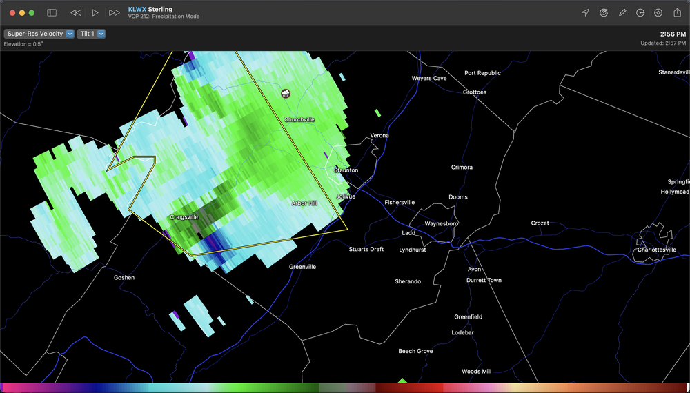
- 2,785 replies
-
- 5
-

-
- severe
- thunderstorms
- (and 3 more)
-
2023 Mid-Atlantic Severe Wx Thread (General Discussion)
andyhb replied to Kmlwx's topic in Mid Atlantic
Storm of most concern at this time looks to be the one approaching the Staunton/Waynesboro VA areas. Strong meso aloft on that cell.- 2,785 replies
-
- 3
-
-
- severe
- thunderstorms
- (and 3 more)
-
2023 Mid-Atlantic Severe Wx Thread (General Discussion)
andyhb replied to Kmlwx's topic in Mid Atlantic
I don't know if you want to reach convective temp if you want to maximize severe potential here. Need shear to increase.- 2,785 replies
-
- 3
-
-
- severe
- thunderstorms
- (and 3 more)
-
2023 Mid-Atlantic Severe Wx Thread (General Discussion)
andyhb replied to Kmlwx's topic in Mid Atlantic
LCLs aren't ideal in that sounding either, although I'm guessing the HRRR is overmixing, which might also be affecting the modeled wind fields. -
2023 Mid-Atlantic Severe Wx Thread (General Discussion)
andyhb replied to Kmlwx's topic in Mid Atlantic
Going to need to see improvements in the wind profiles over the Mid Atlantic coinciding with convection to get a higher tornado/sig wind threat here. Current VADs from the area are pretty paltry on low level shear (and the RAP doesn't offer substantial improvements). They are better back in E TN/E KY though.- 2,785 replies
-
- 4
-

-
-
- severe
- thunderstorms
- (and 3 more)
-
Multiple vortex confirmed with that.


