andyhb
-
Posts
19,888 -
Joined
-
Last visited
Content Type
Profiles
Blogs
Forums
American Weather
Media Demo
Store
Gallery
Everything posted by andyhb
-

2024 Short/Medium Range Severe Weather Discussion
andyhb replied to Chicago Storm's topic in Lakes/Ohio Valley
Thursday will depend highly on the degree of cyclonic curvature within the mid/upper level flow. Most guidance is not in agreement with the 12z NAM/NAM 3 km idea of having a substantial shortwave eject ENE and induce stronger surface cyclogenesis and LLJ response. The 18z NAM also backed off on that idea. Moisture looks like a non issue and I don't see much concern for a washout especially further south, but the wind fields will be strongly affected by how amplified that feature is. -
2024 Short/Medium Range Severe Weather Discussion
andyhb replied to Chicago Storm's topic in Lakes/Ohio Valley
18z NAM is absolutely nasty in the Midwest (IA/IL) on Thursday. Other models generally are not as favorable although they appear to be shifting towards a solution where a coherent shortwave ejects ENE/NE after Wednesday, which would increase the threat. Very, very cold air aloft with temperatures approaching -20 at 500 mb and -45 to -50 and 300 mb means that you won't need a lot of moisture to get strong updrafts. -
Blocking pattern looks to setup beyond mid month given the ongoing significant SSW and prolonged disruption/decay of the stratospheric PV (perhaps the final warming). Would think moderation of some of the warmth should occur during that period along with a decrease in severe weather chances.
-
New Euro seasonal is pretty ridiculous for this season. The numbers for mean ACE (165+), named storms (17+), and hurricanes (9) in the Atlantic through September (so not even including late season) are all pretty much off the charts. Granted, forecast skill for such predictions is modest at best in March, but also a signal like that has never been seen previously in the ECMWF long range forecasts.
-
Just went right through town.
-
Anyone here on that Atkinson storm? Looks pretty close to producing.
-
Good moisture depth and quality in this 19z observed sounding from UIUC (Champaign).
-
Recent CAM/short-range guidance seems to be on the upswing for tomorrow's threat. For one, that subtle embedded wave aloft that induces surface cyclogenesis along the surface trough seems to be returning (e.g. the earlier Euro runs) that could increase the low level wind response. The RAP in particular has a fairly potent surface cyclone and pseudo-dryline. Moisture seems sufficient across most models as well. I'd be wary of the HRRR overmixing and being too far east at this range. The MPAS from NSSL also seems to have an issue with that, although it has improved from the 00z to the 12z run.
-
12z Euro a big downtrend overall. Less phased with weaker surface cyclogenesis. Bordering on a non event.
-
12z Euro is probably a localized significant tornado event across central IL from I-70 to I-80.
-
00z Euro is kind of a clusterf*ck since none of the waves really interact with each other. Instead it's basically a patchwork of flow on Tuesday despite a fairly large area of instability. Lower end run.
-
2024 Short/Medium Range Severe Weather Discussion
andyhb replied to Chicago Storm's topic in Lakes/Ohio Valley
Tuesday (2/27) could become interesting depending on how that lead wave interacts with the northern stream as it ejects. 12z Euro would probably be a notable severe weather event for Illinois. IMO Wednesday will struggle with a lack of instability, but there are large D6/D7 15% risks out from the SPC. -
A lot of uncertainty right now as to how this trough evolves given that there's three pieces involved. The northern stream trough, the southern stream closed low off the SW coast, and a lead wave that looks to eject towards the Midwest on Tuesday and Wednesday looks to have poor instability for the most part. IMO the greatest threat is in the Midwest on Tuesday, especially if the former and the latter features work together in a way that resembles the 12z Euro.
- 1 reply
-
- 1
-

-
2024 Short/Medium Range Severe Weather Discussion
andyhb replied to Chicago Storm's topic in Lakes/Ohio Valley
*sigh* why does this nonsense keep happening with almost every tornado event... -
2024 Short/Medium Range Severe Weather Discussion
andyhb replied to Chicago Storm's topic in Lakes/Ohio Valley
...or not -
2024 Short/Medium Range Severe Weather Discussion
andyhb replied to Chicago Storm's topic in Lakes/Ohio Valley
Evansville WI tornado rated prelim EF3 per Damage Assessment Toolkit. 1/7/2008 vibes. -
My bad, Thursday.
-
Lol the RRFS is doing some... things in E IA/W IL tomorrow.
-
Flying into DCA tonight and… well…
-
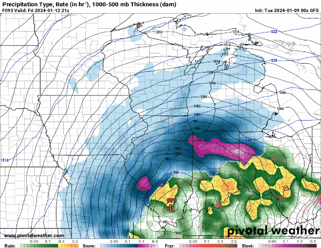
Returns blossoming on KDVN again as the deformation zone starts to crank. They might pull off some huge totals.
-
Welcome to a strong Nino winter in a warming climate.
-
Don’t want that shift to continue if you’re in N IL or you risk mixing and the dryslot.
-
Ope I see that title change.
-
Reminds me quite a bit of a snow footprint with the GHD II storm in 2015.
-
Again, this increase across the board is nearly entirely related to the cold sector precip getting more robust.