andyhb
-
Posts
20,082 -
Joined
-
Last visited
2 Followers


About andyhb

- Birthday March 18
Recent Profile Visitors
17,510 profile views


-
Significant severe wx event is possible tomorrow across much of MO. Very strong shear and favorable boundary orientation for semi discrete supercells should instability be sufficient. CAMs are in strong agreement.
-

Spring 2025 Medium/Long Range Discussion
andyhb replied to Chicago Storm's topic in Lakes/Ohio Valley
Potentially significant severe event setting up for MO/W IL on Sunday with instability/moisture being the main question. Potent, negatively tilted wave quickly ejects across the S Plains during the afternoon and a 50+ kt LLJ provides very strong low level shear ahead of the Pacific front most of the day. -
Violent tornado with that Byhalia MS cell. 80 kt VROT, huge TDS.
-
Large tornado moving directly into Selmer TN, pop nearly 4500, this could be bad.
-
And another strong tornado near Senatobia MS.
-
Strong tornado in progress near Middleton TN currently, perfectly discrete supercell.
-
Warehouse collapsed with people trapped near Brownsburg IN (west side of Indy) from the tornado earlier.
-
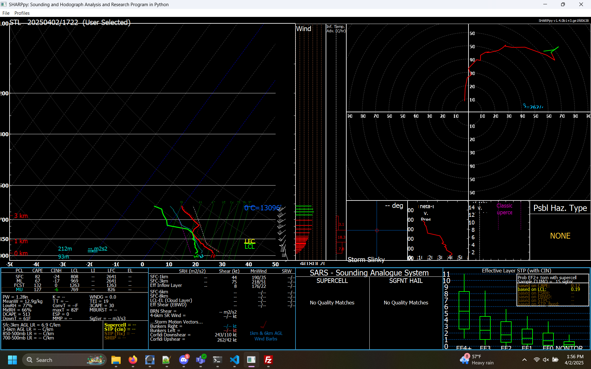
This ACARS profile from St. Louis is bad news from E MO/central IL should any storms get loose ahead of the line. Extremely favorable hodograph for tornadic supercells and a weakening cap.

-
IN/W OH may have some issues later.
-
Plains States Observations and Discussion Thread
andyhb replied to lookingnorth's topic in Central/Western States
Tomorrow could be a very serious severe weather event across KS and southward into OK, particularly in the evening. Incredible shear profiles will overlap with rapidly returning moisture along a 50-70 kt LLJ and weak CIN ahead of a rather potent dryline. -
Spring 2025 Medium/Long Range Discussion
andyhb replied to Chicago Storm's topic in Lakes/Ohio Valley
12z Euro is also a major event. Very volatile parameter space across a very large area with relatively subtle forcing for ascent and a weak cap is a recipe for trouble. -
Spring 2025 Medium/Long Range Discussion
andyhb replied to Chicago Storm's topic in Lakes/Ohio Valley
Really, really need a thread for 4/2-3 here soon. Major outbreak on the 12z GFS from IL/IN all the way southward to central MS. -
Could be a pretty nasty nocturnal threat with this one especially closer to the Ohio River.
-
Spring 2025 Medium/Long Range Discussion
andyhb replied to Chicago Storm's topic in Lakes/Ohio Valley
Volatile, potential widespread severe setup on the 12z Euro/EPS/AIFS next week around 4/2 @RCNYILWX. Have seen that synoptic pattern before and it's consistent with significant GL/Midwest/OV severe events. This has been showing up for several runs now while the GFS is off in la-la land. -
Moisture is mixing out too much, temperatures getting too warm.