Thrasher Fan
-
Posts
1,288 -
Joined
-
Last visited
Content Type
Profiles
Blogs
Forums
American Weather
Media Demo
Store
Gallery
Everything posted by Thrasher Fan
-

1/10-11 super awesome winter SE OBS thread
Thrasher Fan replied to strongwxnc's topic in Southeastern States
They've given up on determining whats falling out of the sky today. Haha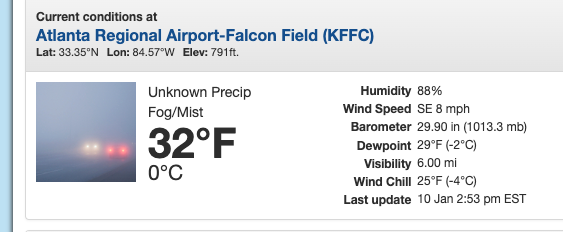
-
1/10-11 super awesome winter SE OBS thread
Thrasher Fan replied to strongwxnc's topic in Southeastern States
Precip hole to the SW of ATL proper starting to fill in on radar. Nothing reaching the ground in PTC as of this moment however. Temp 32° / DP 31.6° -
12z run of the GFS trying its hardest to spin up a bonus LP for Monday/Tuesday. Not quite there but close...
-
1/10-11 super awesome winter SE OBS thread
Thrasher Fan replied to strongwxnc's topic in Southeastern States
Not weather related after further investigation -
1/10-11 super awesome winter SE OBS thread
Thrasher Fan replied to strongwxnc's topic in Southeastern States
Sounds like a horrible disaster was lucky avoided at Hartsfield Jackson International Airport in ATL... https://x.com/ATLairport/status/187774110878607769 Update... this was not weather related. -
1/10-11 super awesome winter SE OBS thread
Thrasher Fan replied to strongwxnc's topic in Southeastern States
Going to have to monitor temps in the ATL metro from here on out. Freezing rain a big concern now, IMO. Glazing on the pines has already started but I am seeing melting in my location. -
1/10-11 super awesome winter SE OBS thread
Thrasher Fan replied to strongwxnc's topic in Southeastern States

-
1/10-11 super awesome winter SE OBS thread
Thrasher Fan replied to strongwxnc's topic in Southeastern States
Never seen sleet rates like this before. Wild -
1/10-11 super awesome winter SE OBS thread
Thrasher Fan replied to strongwxnc's topic in Southeastern States
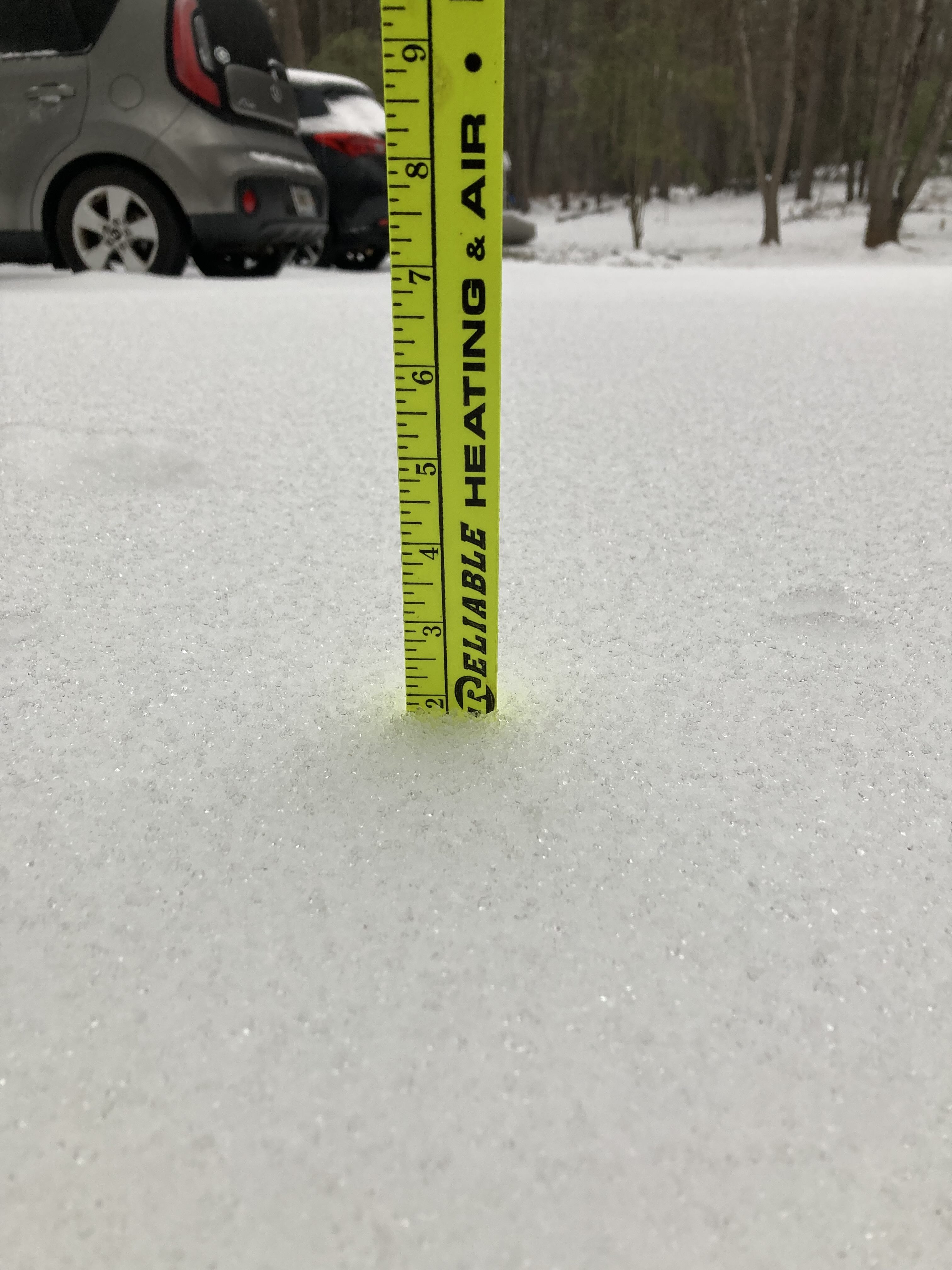
Approaching 2 inches here in Peachtree City. All sleet at the moment. -
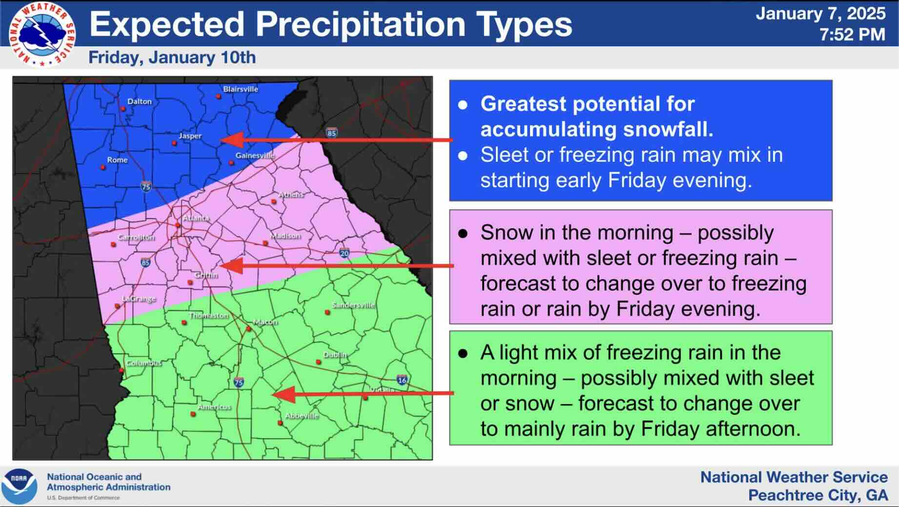
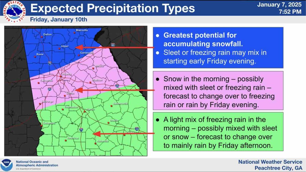
All FFC counties in the Winter Storm Watch upgraded to a Warning. URGENT - WINTER WEATHER MESSAGE National Weather Service Peachtree City GA 214 PM EST Thu Jan 9 2025 GAZ001>009-011>016-019>025-027-030>039-041>060-100600- /O.UPG.KFFC.WS.A.0001.250110T1200Z-250111T1200Z/ /O.NEW.KFFC.WS.W.0001.250110T1200Z-250111T1200Z/ Dade-Walker-Catoosa-Whitfield-Murray-Fannin-Gilmer-Union-Towns- Chattooga-Gordon-Pickens-Dawson-Lumpkin-White-Floyd-Bartow- Cherokee-Forsyth-Hall-Banks-Jackson-Madison-Polk-Paulding-Cobb- North Fulton-Gwinnett-Barrow-Clarke-Oconee-Oglethorpe-Wilkes- Haralson-Carroll-Douglas-South Fulton-DeKalb-Rockdale-Walton- Newton-Morgan-Greene-Taliaferro-Heard-Coweta-Fayette-Clayton- Spalding-Henry-Butts-Jasper-Putnam- Including the cities of Ellijay, Douglasville, Carrollton, LaFayette, Crawfordville, Winder, Dahlonega, Marietta, Lawrenceville, Atlanta, Cleveland, Summerville, Cartersville, Washington, Franklin, Riverdale, Bremen, Crawford, Madison, Jasper, Hiawassee, Griffin, Newnan, Stockbridge, Eatonton, Monticello, Comer, Decatur, Fort Oglethorpe, Conyers, Cedartown, Trenton, Woodstock, Greensboro, Dallas, Calhoun, Jackson, Dalton, East Point, Commerce, Rome, Dawsonville, Watkinsville, Chatsworth, Blairsville, Peachtree City, Gainesville, Blue Ridge, Monroe, Athens, Cumming, Covington, and Homer 214 PM EST Thu Jan 9 2025 ...WINTER STORM WARNING IN EFFECT FROM 7 AM FRIDAY TO 7 AM EST SATURDAY... * WHAT...A mix of multiple winter precipitation types are expected. Total snow and sleet accumulations up to 3 inches and ice accumulations up to one third of an inch are possible. * WHERE...Portions of central, east central, north central, northeast, northwest, and west central Georgia. * WHEN...From 7 AM Friday to 7 AM EST Saturday. * IMPACTS...Roads, and especially bridges and overpasses, will likely become slick and hazardous. Significant ice accumulation on power lines and tree limbs may cause widespread and long-lasting power outages. Plan on slippery road conditions. The hazardous conditions could impact the Friday morning and evening commutes. * ADDITIONAL DETAILS...Ice accumulations have been increased across portions of the I20 and I85 corridors. Additional changes to ice and snow amounts are possible with future forecast updates. PRECAUTIONARY/PREPAREDNESS ACTIONS... If you must travel, keep an extra flashlight, food, and water in your vehicle in case of an emergency. The latest road conditions for the state you are calling from can be obtained by calling 5 1 1. Persons should consider delaying all travel. Motorists should use extreme caution if travel is absolutely necessary. && $$
-
Wording from FFC remains the same on the Winter Storm Watch from the afternoon synopsis. 418 WWUS42 KFFC 090412 WSWFFC URGENT - WINTER WEATHER MESSAGE National Weather Service Peachtree City GA 1112 PM EST Wed Jan 8 2025 GAZ001>009-011>016-019>025-027-030>039-041>060-091400- /O.CON.KFFC.WS.A.0001.250110T1200Z-250111T1200Z/ Dade-Walker-Catoosa-Whitfield-Murray-Fannin-Gilmer-Union-Towns- Chattooga-Gordon-Pickens-Dawson-Lumpkin-White-Floyd-Bartow- Cherokee-Forsyth-Hall-Banks-Jackson-Madison-Polk-Paulding-Cobb- North Fulton-Gwinnett-Barrow-Clarke-Oconee-Oglethorpe-Wilkes- Haralson-Carroll-Douglas-South Fulton-DeKalb-Rockdale-Walton- Newton-Morgan-Greene-Taliaferro-Heard-Coweta-Fayette-Clayton- Spalding-Henry-Butts-Jasper-Putnam- Including the cities of Madison, Commerce, Blairsville, Jackson, Trenton, Blue Ridge, Cumming, Calhoun, Winder, Bremen, Douglasville, Crawford, Woodstock, Carrollton, Peachtree City, Watkinsville, Dahlonega, Greensboro, Ellijay, Washington, Griffin, Stockbridge, Covington, Hiawassee, Lawrenceville, Eatonton, Gainesville, Decatur, Monroe, Riverdale, Rome, Jasper, Homer, Dallas, Monticello, Marietta, Cleveland, East Point, LaFayette, Newnan, Fort Oglethorpe, Comer, Atlanta, Athens, Conyers, Dalton, Crawfordville, Chatsworth, Franklin, Summerville, Cedartown, Cartersville, and Dawsonville 1112 PM EST Wed Jan 8 2025 ...WINTER STORM WATCH REMAINS IN EFFECT FROM FRIDAY MORNING THROUGH SATURDAY MORNING... * WHAT...Periods of snow, sleet, and freezing rain that could be heavy at times. Total snow and sleet accumulations between 3-6 in northern Georgia and 1-3 inches in metro Atlanta and points east. Ice accumulations around a tenth to two tenths of an inch are possible in metro Atlanta and points east. * WHERE...Much of north Georgia. * WHEN...From Friday morning through Saturday morning. * IMPACTS...Plan on slippery road conditions, with travel likely becoming difficult. The hazardous conditions could impact the Friday commute and linger into Saturday morning. Bridges and overpasses could become icy even if temperatures remain slightly above freezing. PRECAUTIONARY/PREPAREDNESS ACTIONS... Monitor the latest forecasts for updates on this hazardous situation. Any slight deviations in temperatures or track of the weather system will result in changes for the precipitation type forecast. && $$
-
0z ICON with a general jog south on LP track for the duration of the event.
-
NWS FFC hoists their first map...
-
NWS GSP office currently posting tornado surveys with a winter storm imminent. Wild times we are in right now.
-
Our good friend Mr. Wetbulb will intervene
-
N Ga.... that's a Big Dawg run from the GFS
-
GFS, be a goodie and jog everything south about 50 miles...
-
Temps are a mess this run. Nothing is locking in the cold to the north. Rinse and repeat
-
Mid to Long Range Discussion ~ 2024
Thrasher Fan replied to buckeyefan1's topic in Southeastern States
Getting into fantasy land now but I liked the trends today for both storm chances. -
Mid to Long Range Discussion ~ 2024
Thrasher Fan replied to buckeyefan1's topic in Southeastern States
2nd storm chance is really slow to eject east. Brutal cold locking in to its north... New Orleans blizzard? haha... -
Mid to Long Range Discussion ~ 2024
Thrasher Fan replied to buckeyefan1's topic in Southeastern States
Next round is digging a lot further west at 180.... -
Mid to Long Range Discussion ~ 2024
Thrasher Fan replied to buckeyefan1's topic in Southeastern States
Its trying to plow into a very dry airmass offshore in the atlantic. Transfer of available moisture northward didn't happen that run though. Good trend for NC folks -
Mid to Long Range Discussion ~ 2024
Thrasher Fan replied to buckeyefan1's topic in Southeastern States
Social media is about to light up with this run... -
Mid to Long Range Discussion ~ 2024
Thrasher Fan replied to buckeyefan1's topic in Southeastern States
bit further west too ejecting out Canada -
Mid to Long Range Discussion ~ 2024
Thrasher Fan replied to buckeyefan1's topic in Southeastern States
Out to 90 on the 0z and looks similar to 18z. Maybe a hair colder, similar moisture.