

ncjoaquin
-
Posts
1,477 -
Joined
-
Last visited
Content Type
Profiles
Blogs
Forums
American Weather
Media Demo
Store
Gallery
Posts posted by ncjoaquin
-
-
Thoughts and prayers for all that we somehow get through this unscathed. A forecast bust seems all but impossible now. So, l hope for the best for all my weather board friends. Already have heavy rain and thunder.
-
 7
7
-
-
Just now, Rainforrest said:
Well a tropical storm watch for Transylvania county. That’s a new one. Lol
Just getting ready to post that. This is the one for Buncombe.
The first person who says after the fact that "the NWS didn't even say it was going to rain" needs to be told what an idiot that they are. It will happen. It does every time.
The NWS pulled no punches talking about how dangerous it is. Now, it is up to the public to listen and use common sense.
-
2
-
 1
1
-
-
56 minutes ago, BretWx said:
Insane. And in such a short period of time. This one might be for the books.
We can hope not, but I'm afraid that you are correct.
-
2
-
-
2 hours ago, Rainforrest said:
I see that purple starting to creep into the picture. Not good at all.
No, absolutely not! You are going to see monumental totals.
-
Just now, strongwxnc said:
I picked up 1.95” last night in two different cells. Heavy rain!
.Wow! I had an inch yesterday. It is not looking good.
-
-
-
1 minute ago, Met1985 said:
Yeah as shown currently this is going to be a historical event.. Not hyping but just looking at the data. Again any sudden change with this thing and that could greatly impact our area but so far all models have us as ground zero.
They definitely do. It is not hype at all. It is a scary scenario.
-
1
-
-
13 minutes ago, Met1985 said:
I bet these will be upped as well. This is still extremely impressive. Also if the thing ends up strengthening a good bit that will really put us under the gun for some extreme weather.
I wish it would all be as wrong as some of the snow forecasts of the past. This sounds like misery ahead. Chain sawing trees and being without power don't top my list of favorite things to do.
-
1
-
-
30 minutes ago, Met1985 said:
Big storms rolling through.
Sent from my SM-G998U using Tapatalk
Absolutely hammering here. Over an inch of rain and still pouring. Definitely did not need this.
-
1
-
-
1 hour ago, Met1985 said:
Finally getting some nice pop up storms.
There he is. When you're gone, I know nothing is going on! Plenty of thunder here, but no rain so far.
-
1
-
-
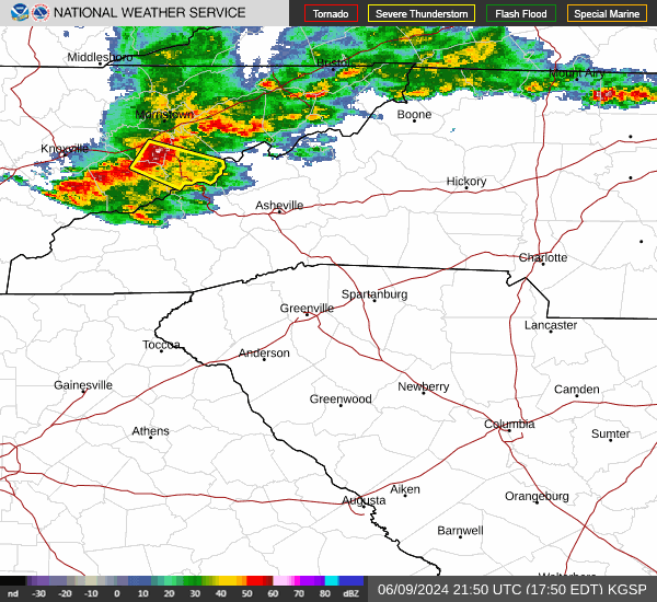
The airport has 2.95 inches of rain in the last 3 hours, and it is still raining!
-
1
-
-
1 minute ago, Met1985 said:
It's coming
Sent from my SM-G998U using Tapatalk
Just checking this out. Looks rough!
-
1
-
-
One heck of a storm here in Candler. Severe thunderstorm warning Buncombe. Tornado warning Eastern Buncombe.
-
1
-
-
4 minutes ago, Buckethead said:
Yeah it is.
Here's the video...it moved it quick.
https://www.instagram.com/reel/C5rRzYxx54_/?igsh=MWJtaDU3djZhd3c3NA==
Sent from my SM-S908U using Tapatalk
That is amazing. So cool!! Great pictures.
-
1
-
-
1 hour ago, Buckethead said:
That happened fast.


Sent from my SM-S908U using Tapatalk
Wow!! That is crazy!!! Is that at your place?
-
2
-
-
49 minutes ago, BooneWX said:
Surprised it’s so quiet in here! The GFS laid the hammer for the central mts and points north Friday. Verbatim it was a nice thumping of wet snow, 3-7 inches.
Saw that. Looks higher elevation, but it has some time.
-
32 minutes ago, Met1985 said:
The warmth we have experienced is pretty crazy so far this month. What's our departures currently? Plus 6 or 8? The only cold place in the country currently is the inner mountain west which have been getting hammered by snow for weeks now.
The airport is 6.8 above without even adding in today's +14.
-
1
-
-
GFS throws us a bone next Tuesday. It's probably gone at 18z. Like Met has said, there is at least a chance coming up.
-
2
-
-
42 minutes ago, UnionCountyNCWX said:
![May be an image of map and text that says 'NOAA WPC Total Precipitation (inches] +168 Hours Accumulation --> thru Tue 12Z12MAR2024 Forecast Issuance: 12Z05MAR2024 7-DAY RAINFALL POTENTIAL MAX: 5.20 INCH weathermodels.com 30 14 3.5 0.15 .05'](https://scontent-iad3-2.xx.fbcdn.net/v/t39.30808-6/430057955_974489934046484_8381289293878271330_n.jpg?_nc_cat=111&ccb=1-7&_nc_sid=524774&_nc_ohc=J2-tJoV1fs8AX9_SChL&_nc_ht=scontent-iad3-2.xx&oh=00_AfAWIgSLZu_VNH1pnEOSxNY_yZPQlLS53nFmP8Zuhe49rA&oe=65EC21E1)
I'm blaming you lol
Ha! Ha! I'll take responsibility.
-
I noticed that on this date in 1969, Asheville had 6.4 inches of snow.
-
2
-
-
22 minutes ago, UnionCountyNCWX said:
Nah, we need to dry out, forget the wet lol
Ha! Ha! I have a well. It always makes me nervous when it gets dry. But, otherwise, I agree with you,lol.
-
47 minutes ago, wncsnow said:
February is likely going to end up below average with rain compared to a very wet January. Water levels are at mid summer levels
February has sucked all the way around. Hopefully, March is wet. That, at least, looks possible.
-
1 minute ago, wncsnow said:
Looks like the GFS backed way off any CAD related mixed precip. Definitely the winter theme. Probably a decent weekend in the 60s for most!
Warm it up! Hopefully, we keep the rain train. It's been a little dry lately.
-
1
-

Major Hurricane Helene
in Southeastern States
Posted
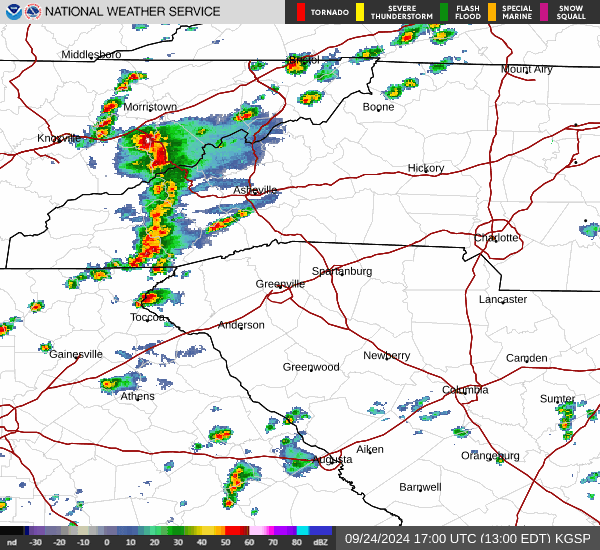
Downtown Asheville rain gauge already over 2 inches.
https://www.ncei.noaa.gov/access/asheville-weather/