forkyfork
-
Posts
30,795 -
Joined
-
Last visited
Content Type
Profiles
Blogs
Forums
American Weather
Media Demo
Store
Gallery
Everything posted by forkyfork
-
i hope the ski industry collapses
-

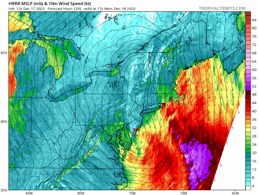
Moderate-High Impact Storm Noon Sun Dec 17, 2023 - 4PM Mon Dec 18. Flooding rain I95 corridor northwestward, coastal tidal flooding, brief periods of damaging 50 MPH+ wind gusts LI/CT Monday, ends as a little wet snow interior elevations Tue morning.
forkyfork replied to wdrag's topic in New York City Metro
imo the most damage is going to come from the burst of winds on the backside of the low after we get 3-5" of rain
- 489 replies
-
- 4
-

-
- flooding rains
- coastal flooding
- (and 4 more)
-
Moderate-High Impact Storm Noon Sun Dec 17, 2023 - 4PM Mon Dec 18. Flooding rain I95 corridor northwestward, coastal tidal flooding, brief periods of damaging 50 MPH+ wind gusts LI/CT Monday, ends as a little wet snow interior elevations Tue morning.
forkyfork replied to wdrag's topic in New York City Metro
- 489 replies
-
- 4
-
-
- flooding rains
- coastal flooding
- (and 4 more)
-
Moderate-High Impact Storm Noon Sun Dec 17, 2023 - 4PM Mon Dec 18. Flooding rain I95 corridor northwestward, coastal tidal flooding, brief periods of damaging 50 MPH+ wind gusts LI/CT Monday, ends as a little wet snow interior elevations Tue morning.
forkyfork replied to wdrag's topic in New York City Metro
the gfs/nam/ukmet camp would bring 50 kt winds inland while the euro/rgem/ggem would keep those winds confined to long island- 489 replies
-
- 2
-
-
- flooding rains
- coastal flooding
- (and 4 more)
-
Moderate-High Impact Storm Noon Sun Dec 17, 2023 - 4PM Mon Dec 18. Flooding rain I95 corridor northwestward, coastal tidal flooding, brief periods of damaging 50 MPH+ wind gusts LI/CT Monday, ends as a little wet snow interior elevations Tue morning.
forkyfork replied to wdrag's topic in New York City Metro
lol- 489 replies
-
- 5
-

-
- flooding rains
- coastal flooding
- (and 4 more)
-
Moderate-High Impact Storm Noon Sun Dec 17, 2023 - 4PM Mon Dec 18. Flooding rain I95 corridor northwestward, coastal tidal flooding, brief periods of damaging 50 MPH+ wind gusts LI/CT Monday, ends as a little wet snow interior elevations Tue morning.
forkyfork replied to wdrag's topic in New York City Metro
the ukmet looks interesting with the follow up wave but these kinds of setups tend to fail- 489 replies
-
- 1
-
-
- flooding rains
- coastal flooding
- (and 4 more)
-
-
2009 was probably the region's last widespread white christmas
-
just give up on ever hoping for a white christmas again if you don't live in the NNE mountains
-
this is just funny, sry to all who are offended
-
your inflatable santa will be ok
-
nino climo says any pattern change waits until mid to late january
-
the nssl wrf forecast looks reasonable to me
-
december is a fall month
-
we couldn't do it in a nina last dec with a negative ao and nao
-
dec 82 had a 2-4" event
-
this is terribad for winter lovers
-
december isn't a winter month anymore and white christmases are disappearing
-
the morning of nemo the euro showed the 2" liquid line well into nj
-
Extended summer stormlover74 future snow hole banter thread 23
forkyfork replied to BxEngine's topic in New York City Metro
BAM! weather! -
the peak winds aloft happen around 12z and winds are sse. snooze
-
i can't find the dwarfing rootstock i want
-
climate change is taking this away from most of us
-
it's that magical time of year when guys in new england hope for a pattern change around christmas